The Hike to Emerald Falls at Loyalsock State Forest near Forksville, Pennsylvania is a moderate 2.6-mile out-and-back hike that leads along seldom-maintained log grades to reach a secluded 15-foot cascade known as Emerald Falls.
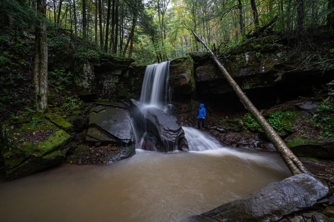
Emerald Falls is a beautiful approximately 15 foot waterfall tucked away in the Loyalsock State Forest along Swamp Run. I have found that this waterfall is worthwhile and picturesque even during lower water flow and also makes a great rainy day with a spot to take a break and shelter from the rain with cave like area at the base of the waterfall.
There are multiple routes to hike into Emerald Falls, I'll detail what I have found as the easiest and it also has the bonus of parking at an incredibly scenic portion of Hoagland Branch.
Parking:
There is a small pull off along Hoagland Branch Road just after crossing a small bridge (41.486939, -76.707538). This also happens to one of the most beautiful roadside spots in the Loyalsock State Forest with High Bridge Falls cascading into Hoagland Branch.
Hike:
This route mostly follows old trails and grades, however they don't seem to get much maintenance and I have had to navigate around downed trees on my hike in.
From the pull-off, walk back across the bridge and look for the faint start to the trail that goes up and across High Bridge Falls. The start of this trail has red blazes as you hike above Hoagland Branch. At about 0.2 mile, the red blazes will go left uphill, you could take this, but I continued straight. About 0.1 mile further, I took what is a more gradual climb to the left on what seemed to be a game trail that will reconnect with the red blazes on an old grade. Continue on this old grade and once again ignore red blazes that ascend to the left of the grade. Once you are at about 1 mile into the hike, you will see yellow blazes, following these down to Swamp Run. This will bring you to a crossing near a small cascade and above Emerald Falls.
At this point you can explore and take in the waterfall how you wish. I find it easiest to get to the bottom of the falls by crossing Swamp Run and then working back down stream to the waterfall and the cave at the base.
There is plenty to explore in this area, there is a slide like cascade just upstream. Swamp Run also has another impressive waterfall known as Triple Falls roughly 0.4 of a mile upstream. This is a more difficult hike as you have to navigate through downed trees and stinging nettle to access, but is well worth it for the off trail explorer. Nearby on the opposite side of Swamp Run that you hiked in on is a sign 'Carolyn Falls' which I have yet to find more info on but can only assume that it is another name for Emerald Falls which maybe used by locals.
Once you are done taking in the beauty of this area, retrace your steps back to Hoagland Branch Road.
Camping & Backpacking
While there are no pre-defined campsites along this hike, dispersed / primitive / backcountry camping is permitted within Loyalsock State Forest. If planning to camp, please follow the state forest rules and regulations.
Pets
Dogs are allowed on this trail and should be leashed and cleaned up after.
Warnings
Off-trail hiking: Note that this hike includes some off-trail hiking that connects old log grades. Some of the old log grades that this hike follows are not maintained, or if they are, are seldomly maintained.
Timber Rattlesnakes: This area is home to the Timber Rattlesnake which can be found roaming the forest floor between the end of April to early October each year. Be on the lookout for any rattlers and give any you find plenty of space.