The High Rock Loop at Worlds End State Park in Forksville, Pennsylvania is a moderate 1.4-mile loop hike that features stunning views of Loyalsock Canyon from High Rock Vista and leads to High Rock Falls.
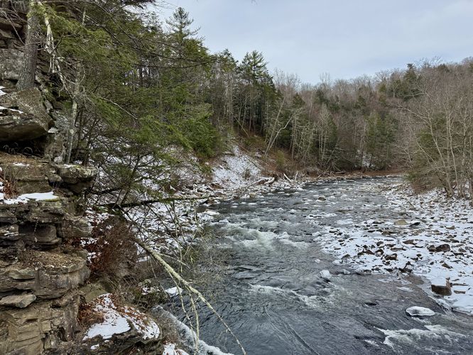
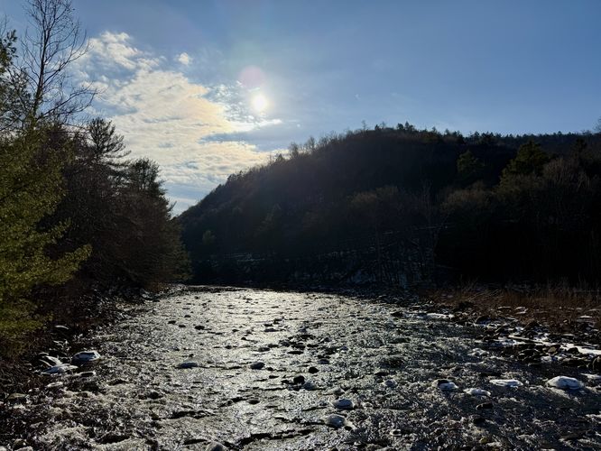
Hikers will begin by following PA-154 from the parking lot west, crossing a bridge that spans Loyalsock Creek. Along the way are nice views of the creek before you'll reach the western trailhead for the High Rock Trail (red blazes).
Timber Rattlesnakes: This area is home to the Timber Rattlesnake which can be found roaming the forest between the end of April and early October each year. Be on the lookout and give any rattler you find plenty of space.
Trails
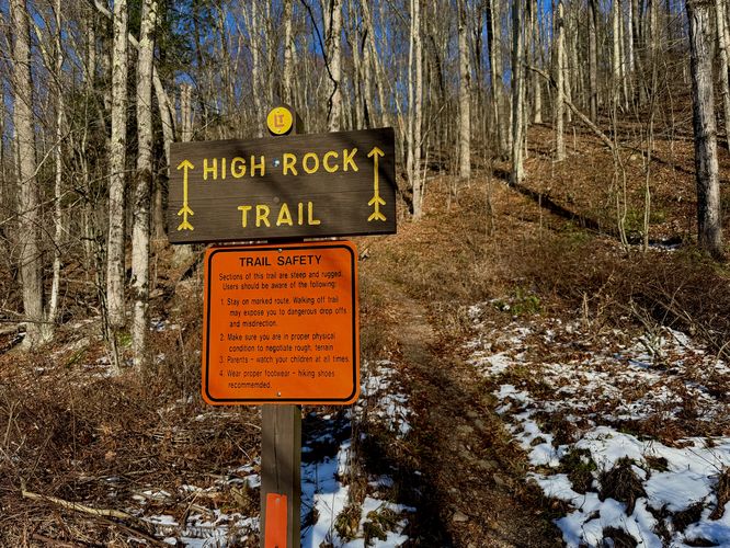
This hike follows one named trail and one road: High Rock Trail (red blazes), Cabin Bridge Road.Hiking the High Rock Loop
This hike begins at the main parking lot for Worlds End State Park, located on the north side of PA-154. Hikers can choose which direction they wish to hike the loop -- this guide technically follow the loop clockwise; however, please note that this is likely the more-difficult way to hike the loop.Hikers will begin by following PA-154 from the parking lot west, crossing a bridge that spans Loyalsock Creek. Along the way are nice views of the creek before you'll reach the western trailhead for the High Rock Trail (red blazes).
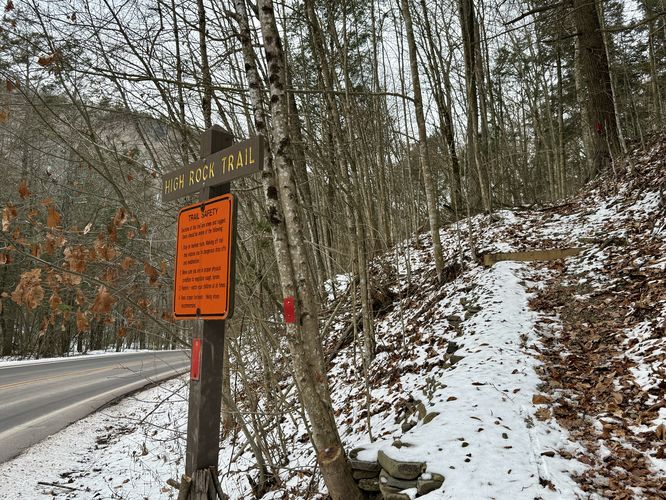
High Rock Trail Trailhead - Mile 0.13
Around mile 0.13, hikers will reach the western terminus for the High Rock Trail. Here, you might want to grab a walking stick before heading up the steep trail. The High Rock Trail ascends the mountain north of Loyalsock Creek with various rocky and root-filled sections, so trekking poles or a walking stick can certainly help. As the trail traverses the mountain ridge along this western ascent, during colder months, you'll find very-obstructed views down into Loyalsock Creek below. Watch your step as the trail leads along very steep slopes.High Rock Vista - Mile 0.45
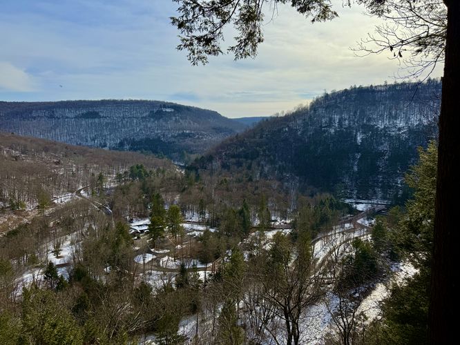
Around mile 0.45, hikers will reach a wooden fence located at the top of a very-steep drop-off. This is the High Rock Vista which provides sweeping views of Loyalsock Canyon, Loyalsock Creek, and a birds-eye view of Worlds End State Park. High Rock Vista is the main attraction for this hike. If you wish to turn around here, you'll save yourself the trouble of descending the rocky trail ahead (and it's less hiking out-and-back). If you wish to hike the loop, continue onward.Hiking to High Rock Falls - Mile 0.45 to 0.7
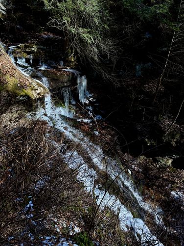
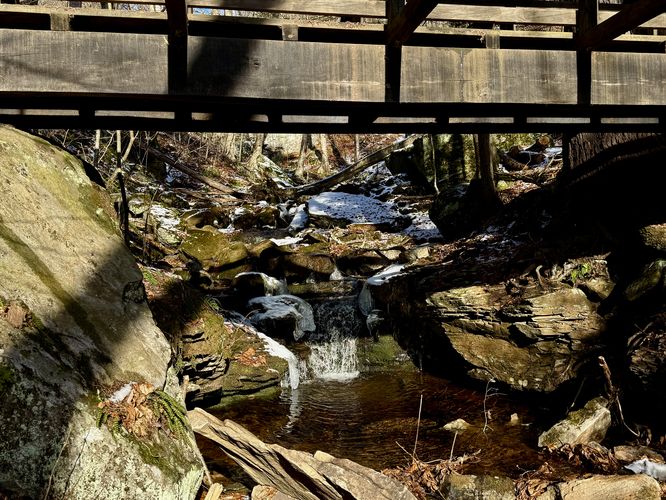
The hike, heading east, from High Rock Vista is not easy (especially during cold months with snow and ice). The trail continues to ascend as it meets up with the Loyalsock Trail before splitting ways. If you stay on-trail, you'll hike up and around a large rocky outcropping which can be annoying. For an easier hike, I'd recommend by-passing this part of the route and follow the unofficial trail that leads below this outcropping for an arguably safer eastbound walk. Despite this short-lived rocky outcropping, the trail will then descend to reach High Rock Run. The trails substrate, leading down this steep hill, is mostly rocks and boulders. This can be tricky during colder months when the rocks are covered in snow and ice, though can be a breeze with the proper footwear during warm months if the rocks are not slippery when wet. The traverse down to reach High Rock Run is not easy nor fun, but it eventually ends around mile 0.67. Just ahead, is a footbridge that crosses High Rock Run, but if you wish to explore off-trail, you can head along a skinny cliff trail that leads down to a view of High Rock Falls / High Rock Run Falls. High Rock Run Falls cascades down from the footbridge at about 25-feet tall, with smaller cascades located up and downstream from the waterfall. Watch your step as this off-trail adventure can be super sketchy.High Rock Run Falls to Cabin Bridge Road - Mile 0.7 to 1
The hike from the High Rock Run footbridge or waterfall to the Cabin Bridge Road is not difficult and is a nice change of pace from the super-steep and rocky High Rock Trail that lead down from the vista.Cabin Bridge Road to Parking - Mile 1 to 1.35
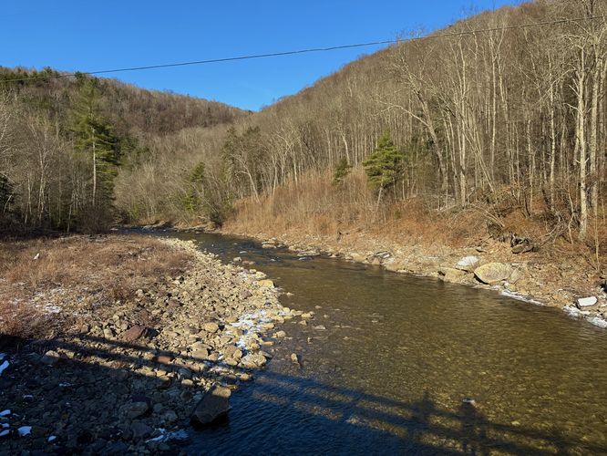
Once on Cabin Bridge Road, hikers will follow the road as it leads west to reach the parking lot. Before reaching parking, you'll find views of Loyalsock Creek from the road's bridge, located around mile 1.05. Beyond the bridge, the road leads through the park, passing a turn for the Loyalsock Trail, before you wrap up the ~1.4-mile hike back at parking.Parking
Hikers will find a very large parking lot at the coordinates provided, located on the north side of PA-154 at the park. The lot is large enough to fit many dozens of vehicles as of December 2024.Pets
Dogs are allowed if leashed and must be cleaned up after.Warning
Steep terrain: The High Rock Trail has steep terrain to avoid (cliffs) and steep trail terrain full of boulders and rocks. Take your time on steep sections of trail to ensure your safety and stay back from cliff ledges. Hike at your own risk.Timber Rattlesnakes: This area is home to the Timber Rattlesnake which can be found roaming the forest between the end of April and early October each year. Be on the lookout and give any rattler you find plenty of space.