Loading...

🔥 End of Summer sale! 50% off on Supporter Accounts — now through September 1st. Learn More.

High Peak Hike

Directions
Map
Pictures
Send to App
Distance:
6.4 Miles / 10.3 km
Type:
Loop
Difficulty:
Moderate
Time to Hike:
3 hours, ~12 minutes
Features:
Surface Type:
Dirt
Park:
George Washington National Forest
Town:
Strasburg, Virginia
Directions:
38.929172, -78.329304
Added:
January 27, 2025
Updated:
April 04, 2025
Guide by:
Copy Trail Link Hiking this trail? Send a friend or family member a link to this trail guide for your own safety. Hike at your own risk (disclaimer)
Loading...
Loading...
1,436'

Total Change
1,740'

Ascent
1,738'

Descent

Download the Trail Route for Offline Use

Supporters get exclusive access to download trail routes to the MyHikes app for offline use. Stay prepared on your adventure, even without an internet connection! Become a Supporter today to unlock this feature and hike with confidence.

Send to App

High Peak Hike

The main attraction of the High Peak hike, located in the George Washington National Forest, is the unbelievable picnic area at Elizabeth Furnace. It is huge! Although there aren't many views and the trail is somewhat rocky it's a great hike to take with a group in the morning and then picnic afterwards.

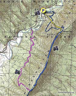
Start on the right of the main parking area where a forestry service bulletin board marks the hikes beginning. Follow the white trail markers through the picnic grounds for 0.3 miles until the trail intersects Passage Creek and turns left uphill following the creek.

After 0.7 miles the white blazed connector trail intersects the pink blazed Sherman Gap Trail. Turn left uphill on the pink blazed trail for 2.5 miles for the steepest portion of the hike as it traverses the mountain then ascends steeply before reaching the ridge line intersention of the blue/orange Tuscarora/Massanutten Trail.

Side hike: If you like views and don't mind a little more hiking go right/south on the old Massanutten East trail from it's intersection with Sherman's Gap Trail (Pink) for maybe 1/2 mile tops. To the left there is a small rock ledge on a sharp point that juts out into the valley with some stunted pine trees ... great view of the Valley and River at the area of the river known as " The Point" for obvious reasons. Just before this is a bit of a saddle. If you find yourself hiking there in June you catch the sweet scent of Fringe Tree (AKA Old Man's Beard). There is a thicket of them to your left as you head south.

If you did not take the side hike above turn left/north and follow the orange/blue blazed trail along the ridge for 2.3 miles, traversing High Peak, before passing one of the only campsites and arriving at a four way intersection where the blue/orange trail now turns left downhill.

Either turn left downhill on the blue/orange blazed trail or take the yellow blazed Shawl Gap Trail (opposite the camping area you passed 15 yards back) that is more direct, however this trail is no longer maintained and has many blow downs. Either trail brings you back to the picnic area. Continue straight through the picnic area, arriving back at the car park.

Explore 92 trails near Strasburg, VA
  1. Parking

    38.929172, -78.329304
  2. Main Trailhead

    38.927465, -78.329537
No community routes found. To add your own hike as a Community Route for this Trail guide, leave a Trip Report with an attached GPX file.

Hazards

Ticks - Lyme Disease More Info (CDC)
Snakes
Poison Ivy/Oak

Seasons

All

Trip Reports (Reviews)

Rated 2.8 out of 5 based on 15 ratings.
By: Sean
6.4 miles / 10.3 km
February 21, 2018
I overdid it taking on this level of hike after being idle for quite a while. I ran out of water, too. (Took one quart, could have used two.) Though I didn't have a great day, that was mainly me -- it's a good, rocky, hike. Good views as there were no leaves -- there won't be many views when the leaves are filled in. Some interesting rock outcroppings. I did not take the side hike given the reviews of others. Turning downhill back toward the Elizabeth Furnace area you are given two choices -- a straight yellow-blazed trail and a longer, curving orange/blue-blazed trail. I recommend the orange/blue blazed trail. The yellow blazes are no longer present on the shorter trail. You can make out the trailhead opposite of the campsite mentioned in the description, but there are two tree trunks laid down. The feeling is "keep out." Maybe they are trying to prevent erosion as it is a steep, straight shot. I started with the orange/blue trail which intersects the formerly-yellow trail several times. At the first intersection, I was really tired and thirsty and thus started down what remained of the shorter "yellow" trail. Soon, on the left, I found a trickle of a spring (the only one I saw in the hike) to my great relief. I continued down the "yellow" trail to near the end, where I lost it when it intersected an Elizabeth Furnace interpretive trail -- I got on that and it was a short downhill walk back to the parking area. My shortcut wasn't that bad. There were about 10 fallen trees, but the fallen leaves weren't being packed down by hikers and the trail is so steep the leaves are slippery -- I had one fall. Thus, the shorter trail is not recommended but if you are desperate for water you may find some on it about a third of the way down if the spring is flowing that day. The main picnic area parking lot was closed and signs say it is closed roughly October through April. You can park in an earlier, smaller lot near the road. The trailhead bulletin board referred to in the description is hidden behind trees and brush near the end of the larger parking lot. There are "vault" toilets, one of which is open in the offseason.
Legacy Review
By: Ed Matthews
6.4 miles / 10.3 km
February 12, 2017
We set out to hike the Little Crease hike as documented here on this site and the hike we took is the combination of that one and this one. This is a hike that is best done in winter because the absence of leaves leads to much nicer views. Alas for us, Sunday started rainy and the low clouds over all the valleys obscured the views, especially of the river, and left us with blazing sun and wearing shorts above the clouds at elevation and sweating under rain gear in the clouds. When I looked at the Little Crease hike on the map, I couldn't figure why it would be an out-and-back when you could just as easily go back to Elizabeth Furnace via the Massanutten/Tuscarora to Shawl Gap and then down the hill to the parking lot. So we made a loop of it, roughly 10.5 miles on the day, and I come to discover that this is the hike documented here as the High Peak Hike. The white-blazed trail along the creek was pretty muddy but the initial climb up after joining the pink-blazed Sherman Gap trail was steady and easy. Then the trail takes a hard left east and starts to really climb. And it's not a level 3 difficulty climb. It's a hard climb more in line with a level 4 difficulty, but not so hard as say the climb up Cedar Run in SNP. Still, even though I hike constantly, it was a heart-pumping climb. There's a lot of rock too. Along the ridgeline from Sherman Gap to Shawl Gap, the rocks start to remind me more and more of Buzzard Rocks just a bit further north and because of all the rock, it is hard to make time on this trail. And certainly impossible on a rainy day when everything is slippery. I'm not a fast hiker and I'm not a slow hiker, but the four hour estimate listed here is certainly unrealistic. I think you should plan on 5 hours plus a half hour for lunch, and even more time if the weather is wet. Note that this includes time to climb Little Crease and walk the half mile to the Shenandoah River overlook. The views on top of Little Crease were really nice (but you wouldn't see much of anything in the summer) especially looking back at High Peak and Buzzard Rocks sticking up out of the clouds. Ditto over at the rock overlook: we couldn't see the river, but the peaks of SNP sticking up out of the clouds were cool. A nice spot for lunch before doing a 180 and heading back. Coming back via Shawl Gap, the switchbacks on the official trail coming out of the gap are a long, long pain in the butt. You can save a half an hour by heading straight down the jeep road. If I ever hike this again, I won't do the pointless, pointless, long, and endlessly meandering switchbacks.
Legacy Review
By: Diego S
6.4 miles / 10.3 km
October 02, 2016
As others have said, there is no real view as is suggested if you head south when you get to the top of the ridge. Don't even bother with it. This hike didn't have much to offer once we got away from the Elizabeth Furnace recreation area and Little Passage Creek. The last half mile or so on the Sherman Gap (pink) Trail was easily the most strenuous park of the hike. Once upon the ridge line, views of the valley to the east are obscured by the forest. For the last portion back down the mountain, we started out on the blue/orange trail. The Shawl Gap (yellow) trail was not visible, or maybe I didn't look hard enough. At the first crossing of the yellow and blue/orange trails, we switched to the yellow trail. It is no longer maintained and I didn't see any yellow blazes, but it is a clear trail, and a straight shot downhill. We ran into a few blowdowns which were not difficult to get over. Taking this trail instead of the blue/orange definitely saves time. I would rate the views as a 2 for this time of year. While there are only two campsites (I think) on the trail, there is abundant camping on Fort Valley Road (SR 678). Our hike was about 7.85 miles if you start the count right from the parking lot.
Legacy Review

Weather Forecast

In Strasburg, VA

Explore Hiking Trails

You May Also Like

New York's Best Waterfalls - Whether you're planning a day hike, roadside stop, or a leisurely short walk, this guide provides hikers, travelers, and locals alike with 63 different locations to over 100 scenic waterfalls to help plan your next adventure!
Explore

New York's Best Waterfalls

Whether you're planning a day hike, roadside stop, or a leisurely short walk, this guide provides hikers, travelers, and locals alike with 63 different locations to over 100 scenic waterfalls to help plan your next adventure!

Read
25 Best Day Hikes in North Carolina - Discover the top 25 best day hikes in North Carolina, from breathtaking waterfalls to mountain peaks. Explore hidden gems, scenic views, and trails suitable for all skill levels, perfect for your next outdoor adventure.
Explore

25 Best Day Hikes in North Carolina

Discover the top 25 best day hikes in North Carolina, from breathtaking waterfalls to mountain peaks. Explore hidden gems, scenic views, and trails suitable for all skill levels, perfect for your next outdoor adventure.

Read

Before you boogie...

Find our trail guides useful? Consider becoming a Supporter to unlock perks!

MyHikes is an indie platform that makes exploring public trails easier for everyone. The platform has no investors, no ads, and is owned and operated by one person, Dave Miller. Dave has personally mapped and written over 1,800 trail guides on MyHikes for the public to explore. MyHikes has helped millions outdoor enthusiasts plan their next adventure.

But it takes a lot of time 🕦, money 💰, work, and espresso shots ☕ to run MyHikes, including hiking , mapping , writing , and publishing new trails with high-quality (accurate) information... along with software engineering (coding) the platform like building new features, website and mobile app development (iOS and Android), site maintainance . and much much more.

Supporters unlock website and mobile app perks with an annual one-time payment of $25 (you renew) 😎👍. Or you can simply make a Donation of your choice. Otherwise, you can support us by telling your friends about MyHikes - both quick and free 🎉

Admin user profile picture

Dave Miller
MyHikes Founder