Loading...

🎉 Enjoy a Free 7-Day Supporter Trial and Unlock Exclusive Perks — No Credit Card Required. Learn more.

High Meadows and Seneca Creek Hike

Directions
Map
Pictures
Send to App
Distance:
13.2 Miles / 21.2 km
Type:
Loop
Difficulty:
Moderate
Time to Hike:
6 hours, ~36 minutes
Features:
Surface Type:
Dirt
Park:
Monongahela National Forest
Town:
Circleville, West Virginia
Directions:
38.711786, -79.549942
Added:
March 18, 2025
Updated:
April 05, 2025
Copy Trail Link Hiking this trail? Send a friend or family member a link to this trail guide for your own safety. Hike at your own risk (disclaimer)
Loading...
Loading...
1,097'

Total Change
1,459'

Ascent
1,459'

Descent

Download the Trail Route for Offline Use

Supporters get exclusive access to download trail routes to the MyHikes app for offline use. Stay prepared on your adventure, even without an internet connection! Become a Supporter today to unlock this feature and hike with confidence.

Send to App

High Meadows and Seneca Creek Hike

The sister hike to the Allegheny/Seneca Creek circuit, the High Meadows loop also has spectacular views from two open pastures on Spruce Mountain. With views, Seneca Falls, and some of the best camping spots in the Monongahela, the Spruce Knob/Seneca Creek area is one of the best backpacking destinations on the east coast.

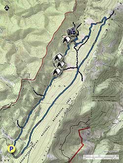
From the Seneca Creek parking area, hike up FR112 for the only section of road walking on the loop. In 0.7 miles turn left off FR112 onto the Lumberjack Trail (TR534). All the trails are marked with blue diamonds.

The Lumberjack Trail is very boggy, even in dryer weather. If there has been any rainfall within the past week be prepared to take extra time on the the Lumberjack Trail. Follow the Lumberjack Trail for 3.6 miles and arrive at the intersection of the Huckleberry Trail (TR533). Continue straight on the Lumberjack Trail for another 2.0 miles, passing through a small clearing, then arriving at the High Meadows Trail junction.

Stay left on the High Meadows Trail where in 150 yards it cuts back to the left heading steeply downward for 0.4 miles before entering the first set of meadows. Cross to the opposite side of the meadow where a blue diamond trail post marks the descent, and several acres of wild blackberry bushes. After passing through the blackberry's the trail will turn back to the left and reenter the forest. Continue to follow the trail for 0.4 miles, then be alert as the trail turns right downhill off the old path it has been following.

At this point the High Meadows Trail passes through a rocky area in the forest, and is hard to follow for the next 200 yards before entering the next set of meadows. Follow the blue diamond trail markers through the meadows as it descends to the left for another 0.4 miles before heading more directly downward, then turning more uphill to the left.

As you enter the forest cross a small stream, and arrive at the next intersection. Turn right downward towards Seneca Creek (the arrow has been scrapped off the sign), and in 0.2 miles reach Seneca Creek at which point the trail turns right downstream. Continue for 0.1 miles, turn left crossing a small gully, and in 150 yards turn sharply down to the junction of the Seneca Creek Trail (TR515).

You will cross Seneca Creek here, but first turn right for 75 yards to the Seneca Falls overlook. There are also several campsites 100 yards further on. After visiting the falls head back up the trail and cross Seneca Creek, and pass a campsite on the right. Continue on the right bank of the creek for 1.0 miles before crossing back over to the left bank. In 100 yards there is single campsite at the top of a small waterfall, and in another 200 yards a larger camping area. Cross Seneca Creek again, and in 0.1 miles there is one of the prettiest camping spots in the Monongahela with a waterfall on the opposite back.

In 0.1 miles pass the intersection of the Bear Hunter Trail on the right before arriving at the Judy Springs campground. Pass through the campground, and continue past the Judy Springs Trail (TR512) on the left, DO NOT cross the footbridge. In 0.5 miles cross Seneca Creek for the last time where the trail becomes easier to follow for the remainder of the hike. Pass the Swallow Rock Trail in another 0.5 miles, and the Tom Lick Trail 1.4 miles further on. 1.0 miles past the Tom Lick Trail arrive back at the Seneca Creek parking area.

Explore 62 trails near Circleville, WV
  1. Parking

    38.711786, -79.549942
  2. Main Trailhead

    38.711786, -79.549942
No community routes found. To add your own hike as a Community Route for this Trail guide, leave a Trip Report with an attached GPX file.

Hazards

Ticks - Lyme Disease More Info (CDC)
Snakes
Poison Ivy/Oak

Seasons

All

Trip Reports

Trail Guide By:
HikingUpward user profile picture
13.2 miles / 21.2 km

Weather Forecast

In Circleville, WV

Explore Hiking Trails

You May Also Like

Colorado's Million Dollar Highway - Plan a day's drive adventure along the iconic Million Dollar Highway in Colorado. Explore the best short trails, roadside stops, waterfalls, vistas, ghost towns, and hot springs within a ~6 hour road trip.
Explore

Colorado's Million Dollar Highway

Plan a day's drive adventure along the iconic Million Dollar Highway in Colorado. Explore the best short trails, roadside stops, waterfalls, vistas, ghost towns, and hot springs within a ~6 hour road trip.

Read
New York's Best Waterfalls - Whether you're planning a day hike, roadside stop, or a leisurely short walk, this guide provides hikers, travelers, and locals alike with 63 different locations to over 100 scenic waterfalls to help plan your next adventure!
Explore

New York's Best Waterfalls

Whether you're planning a day hike, roadside stop, or a leisurely short walk, this guide provides hikers, travelers, and locals alike with 63 different locations to over 100 scenic waterfalls to help plan your next adventure!

Read

Before you boogie...

Find our trail guides useful? Consider becoming a Supporter to unlock perks!

MyHikes is an indie platform that makes exploring public trails easier for everyone. The platform has no investors, no ads, and is owned and operated by one person, Dave Miller. Dave has personally mapped and written over 1,800 trail guides on MyHikes for the public to explore. MyHikes has helped millions outdoor enthusiasts plan their next adventure.

But it takes a lot of time 🕦, money 💰, work, and espresso shots ☕ to run MyHikes, including hiking , mapping , writing , and publishing new trails with high-quality (accurate) information... along with software engineering (coding) the platform like building new features, website and mobile app development (iOS and Android), site maintainance . and much much more.

Supporters unlock website and mobile app perks with an annual one-time payment of $25 (you renew) 😎👍. Or you can simply make a Donation of your choice. Otherwise, you can support us by telling your friends about MyHikes - both quick and free 🎉

Admin user profile picture

Dave Miller
MyHikes Founder