Loading...

๐ŸŽ‰ Enjoy a Free 7-Day Supporter Trial and Unlock Exclusive Perks โ€” No Credit Card Required. Learn more.

High Falls Trail

Directions
Map
Pictures
Send to App
Distance:
0.2 Miles / 0.3 km
Type:
Out-and-Back
Difficulty:
Easy
Time to Hike:
~6 minutes
Features:
Surface Type:
Universal Access
Town:
Rochester, New York
Directions:
43.163216, -77.613082
Added:
May 04, 2024
Updated:
July 03, 2024
Copy Trail Link Hiking this trail? Send a friend or family member a link to this trail guide for your own safety. Hike at your own risk (disclaimer)
Loading...
Loading...
8'

Total Change
9'

Ascent
9'

Descent

Download the Trail Route for Offline Use

Supporters get exclusive access to download trail routes to the MyHikes app for offline use. Stay prepared on your adventure, even without an internet connection! Become a Supporter today to unlock this feature and hike with confidence.

Send to App

High Falls Trail

The High Falls Trail in Rochester, New York is an easy 0.2-mile out-and-back universally-accessible trail that features views of the 100-foot tall waterfall, High Falls.

Walk
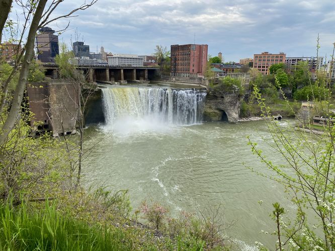
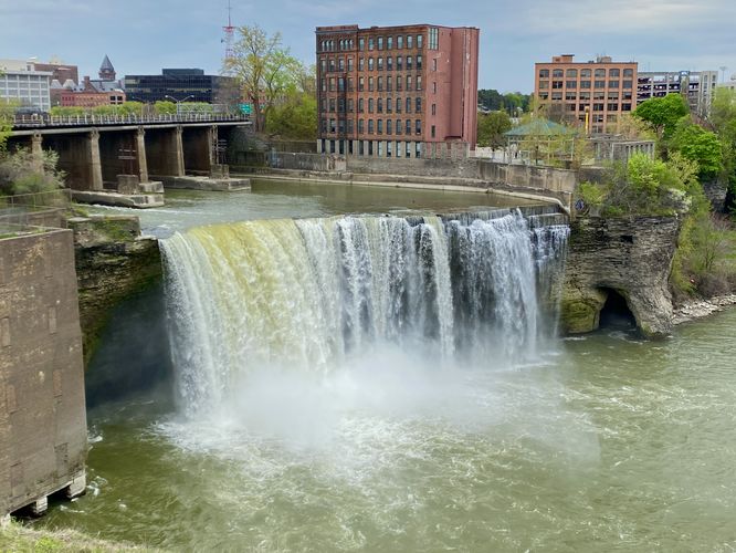
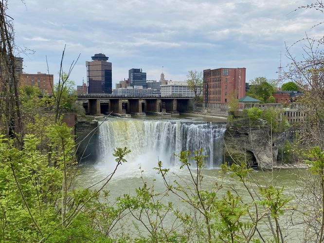
This short trail leads through High Falls Terrace Park following a paved and concrete pathway. Visitors will find the trailhead located at the west side of the small parking lot at the coordinates provided where the universally-accessible trail can be found. The path leads towards the edge of the Genesee River's cliffs and provides several view points of High Falls from the fence. It then leads south to reach a viewing platform that sits on the edge of the river's cliff with a view above High Falls from several hundred feet away. High Falls cascades over a ~100-foot tall cliff within the Genesee River, causing plumes of mist to fill the amphitheater of cliffs within the river.

After exploring High Falls from the viewing platform, this route leads north along the fence and back to parking, while stopping at High Falls viewpoints along the way.

Parking
Visitors will find a small parking lot at the coordinates provided, located on the west side of St Paul Street in Rochester, NY. The lot is large enough to fit less than 10 vehicles as of May 2024.

Pets
Dogs are allowed if leashed and should be cleaned up after.
Explore 5 trails near Rochester, NY
  1. Parking

    43.163216, -77.613082
  2. Main Trailhead

    43.163216, -77.613082
  3. View of High Falls, downtown Rochester NY

    43.162853, -77.612997
    View of High Falls, downtown Rochester NY
  4. High Falls, Rochester NY

    43.162303, -77.612528
    High Falls, Rochester NY
  5. View of High Falls, downtown Rochester NY

    43.162994, -77.613503
    View of High Falls, downtown Rochester NY
No community routes found. To add your own hike as a Community Route for this Trail guide, leave a Trip Report with an attached GPX file.

Hazards

Ticks - Lyme Disease More Info (CDC)

Seasons

All

Weather Forecast

In Rochester, NY

Explore Hiking Trails

You May Also Like

Colorado's Million Dollar Highway - Plan a day's drive adventure along the iconic Million Dollar Highway in Colorado. Explore the best short trails, roadside stops, waterfalls, vistas, ghost towns, and hot springs within a ~6 hour road trip.
Explore

Colorado's Million Dollar Highway

Plan a day's drive adventure along the iconic Million Dollar Highway in Colorado. Explore the best short trails, roadside stops, waterfalls, vistas, ghost towns, and hot springs within a ~6 hour road trip.

Read
Glacier's Going-to-the-Sun Road - Discover the breathtaking beauty of Glacier National Park along the iconic Going-to-the-Sun Road. From stunning roadside stops to picturesque waterfalls and vistas, this engineering marvel offers endless opportunities for exploration.
Explore

Glacier's Going-to-the-Sun Road

Discover the breathtaking beauty of Glacier National Park along the iconic Going-to-the-Sun Road. From stunning roadside stops to picturesque waterfalls and vistas, this engineering marvel offers endless opportunities for exploration.

Read
New York's Best Waterfalls - Whether you're planning a day hike, roadside stop, or a leisurely short walk, this guide provides hikers, travelers, and locals alike with 63 different locations to over 100 scenic waterfalls to help plan your next adventure!
Explore

New York's Best Waterfalls

Whether you're planning a day hike, roadside stop, or a leisurely short walk, this guide provides hikers, travelers, and locals alike with 63 different locations to over 100 scenic waterfalls to help plan your next adventure!

Read

Before you boogie...

Find our trail guides useful? Consider becoming a Supporter to unlock perks!

MyHikes is an indie platform that makes exploring public trails easier for everyone. The platform has no investors, no ads, and is owned and operated by one person, Dave Miller. Dave has personally mapped and written over 1,800 trail guides on MyHikes for the public to explore. MyHikes has helped millions outdoor enthusiasts plan their next adventure.

But it takes a lot of time ๐Ÿ•ฆ, money ๐Ÿ’ฐ, work, and espresso shots โ˜• to run MyHikes, including hiking , mapping , writing , and publishing new trails with high-quality (accurate) information... along with software engineering (coding) the platform like building new features, website and mobile app development (iOS and Android), site maintainance . and much much more.

Supporters unlock website and mobile app perks with an annual one-time payment of $25 (you renew) ๐Ÿ˜Ž๐Ÿ‘. Or you can simply make a Donation of your choice. Otherwise, you can support us by telling your friends about MyHikes - both quick and free ๐ŸŽ‰

Admin user profile picture

Dave Miller
MyHikes Founder