The Hidden Valley Nature Trail at Rocky Mountain National Park near Estes Park, Colorado is an easy 0.7-mile loop hike that features mountain views and opportunities for viewing wildlife.
Hike
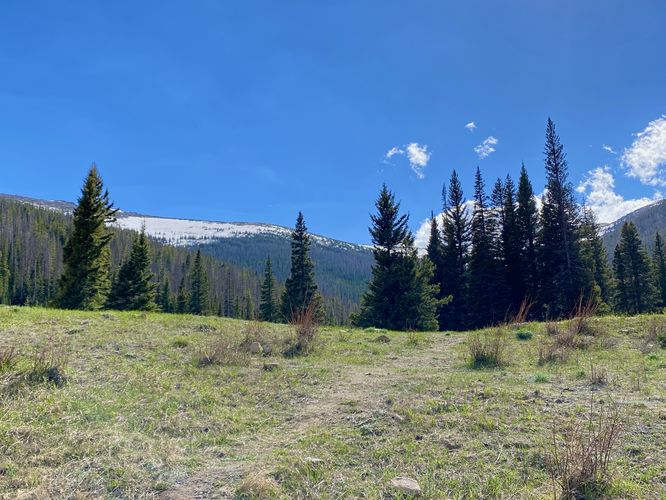
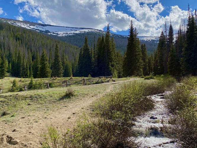
This very short hike begins at the main trailhead for the Hidden Valley Nature Trail and follows a concrete pathway up the hill before turning back toward the main path. There are a couple of entrances to this trail, hence the concrete pathway. The dirt trail (main loop) heads up Hidden Valley with views of the mountains towering overhead, including the mountain ridge known as Tombstone RIdge where the Ute Trail passes through.
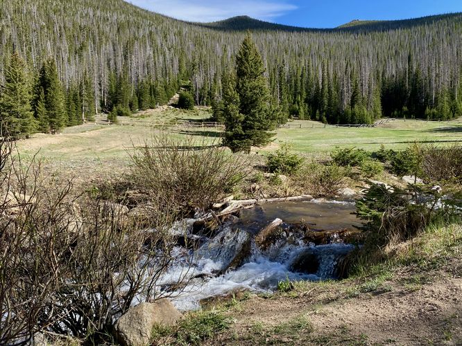
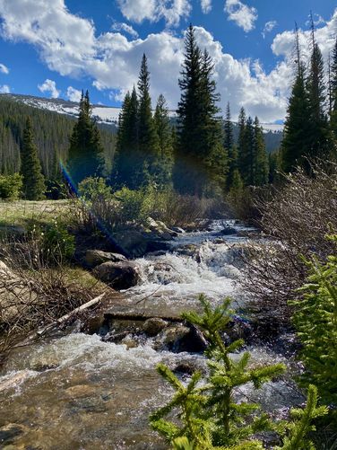
Small Cascades
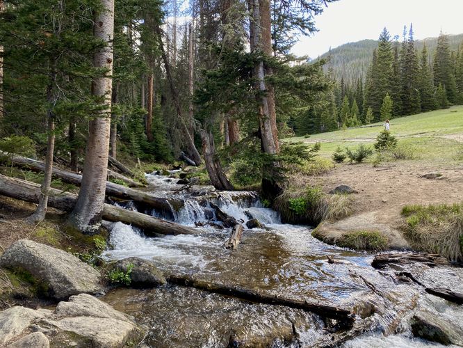
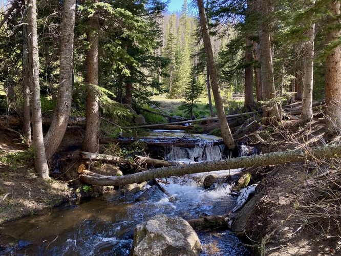
Along the way are small cascades within Hidden Valley Creek that spill down the center of the valley. The trail provides several off-shoot pathways and footbridges that cross the creek and provide additional views of these small waterfalls. Note that none of the cascades are much taller than about 2 or 3-feet, but add to the scenery of the valley nonetheless.
Dead End of Trail - Mile 0.35
Around mile 0.35, if you hike up the creek from the main loop along a skinnier dirt path, you'll reach a dead-end section of the trail. Here, turn back to the main loop to hike back to parking via the opposite side of the trail that you hiked up on.
Footbridge View - Mile 0.66
If you skipped the initial footbridge on the hike in from the main trailhead, this track leads hikers there last just before reaching the parking lot. The footbridge provides additional views up valley of Hidden Valley, the creek, and surrounding mountain ridges.
Wildlife Viewing
This trail is great for viewing wildlife, especially deer, elk, and moose due to the open spaces for grazing and finding food in addition to the creek's water source for drinking. If you wish to spot wildlife, your best chances are in the early morning or in the early evening. Always keep a safe distance while viewing - approx. 75-feet for elk and longhorn sheep; 120-feet for bear and moose.
Pets
Dogs are not allowed on this trail.
Parking
Hikers will find a massive parking lot at the coordinates provided, located within the Hidden Valley section of the park right off of Trail Ridge Road. The lot is large enough to fit many dozens of vehicles.
Timed-Entry Reservations
Between the months of late May through early October you must purchase a timed-entry pass to visit Rocky Mountain National Park. If you wish to visitor and hike anything off of the Bear Lake Road, you must purchase a dedicated Bear Lake timed-entry pass. You can find more information about timed entry on the park's website.
Restrooms
As of June 2024, there are restroom facilities with sinks and flush toilets at the trailhead.
Warnings
Elevation sickness: This trail brings hikers through terrain that ascends up to 9,400-feet above sea level. Around the 7,000-foot mark above sea level, hikers may start to experience symptoms of elevation sickness including headache, muscle aches, shortness of breath, among other warning signs. In order to avoid elevation sickness it's recommended to ascend to higher elevations and take short walks to acclimate over the course of several days before taking a long or physically-demanding hike. At any time you feel elevation sickness kicking in, that's the time to turn back and head for lower altitude or the parking lot.
Wild animals: While rare, hikers may encounter bears or mountain lion along the trail. Again, this is rare due to the insane amount of people who hike these trails each day; however, it's smart to know that these wild animals could be on-trail. Please read-up on how to properly handle a bear or mountain lion encounter before hitting the trails.
Hike
This very short hike begins at the main trailhead for the Hidden Valley Nature Trail and follows a concrete pathway up the hill before turning back toward the main path. There are a couple of entrances to this trail, hence the concrete pathway. The dirt trail (main loop) heads up Hidden Valley with views of the mountains towering overhead, including the mountain ridge known as Tombstone RIdge where the Ute Trail passes through.
Small Cascades
Along the way are small cascades within Hidden Valley Creek that spill down the center of the valley. The trail provides several off-shoot pathways and footbridges that cross the creek and provide additional views of these small waterfalls. Note that none of the cascades are much taller than about 2 or 3-feet, but add to the scenery of the valley nonetheless.
Dead End of Trail - Mile 0.35
Around mile 0.35, if you hike up the creek from the main loop along a skinnier dirt path, you'll reach a dead-end section of the trail. Here, turn back to the main loop to hike back to parking via the opposite side of the trail that you hiked up on.
Footbridge View - Mile 0.66
If you skipped the initial footbridge on the hike in from the main trailhead, this track leads hikers there last just before reaching the parking lot. The footbridge provides additional views up valley of Hidden Valley, the creek, and surrounding mountain ridges.
Wildlife Viewing
This trail is great for viewing wildlife, especially deer, elk, and moose due to the open spaces for grazing and finding food in addition to the creek's water source for drinking. If you wish to spot wildlife, your best chances are in the early morning or in the early evening. Always keep a safe distance while viewing - approx. 75-feet for elk and longhorn sheep; 120-feet for bear and moose.
Pets
Dogs are not allowed on this trail.
Parking
Hikers will find a massive parking lot at the coordinates provided, located within the Hidden Valley section of the park right off of Trail Ridge Road. The lot is large enough to fit many dozens of vehicles.
Timed-Entry Reservations
Between the months of late May through early October you must purchase a timed-entry pass to visit Rocky Mountain National Park. If you wish to visitor and hike anything off of the Bear Lake Road, you must purchase a dedicated Bear Lake timed-entry pass. You can find more information about timed entry on the park's website.
Restrooms
As of June 2024, there are restroom facilities with sinks and flush toilets at the trailhead.
Warnings
Elevation sickness: This trail brings hikers through terrain that ascends up to 9,400-feet above sea level. Around the 7,000-foot mark above sea level, hikers may start to experience symptoms of elevation sickness including headache, muscle aches, shortness of breath, among other warning signs. In order to avoid elevation sickness it's recommended to ascend to higher elevations and take short walks to acclimate over the course of several days before taking a long or physically-demanding hike. At any time you feel elevation sickness kicking in, that's the time to turn back and head for lower altitude or the parking lot.
Wild animals: While rare, hikers may encounter bears or mountain lion along the trail. Again, this is rare due to the insane amount of people who hike these trails each day; however, it's smart to know that these wild animals could be on-trail. Please read-up on how to properly handle a bear or mountain lion encounter before hitting the trails.