The Hickman Bridge Trail at Capitol Reef National Park near Fruita, Utah is a moderate 1.8-mile out-and-back (lollipop) hike that features the stunning natural arch named the Hickman Bridge.
Hike Description
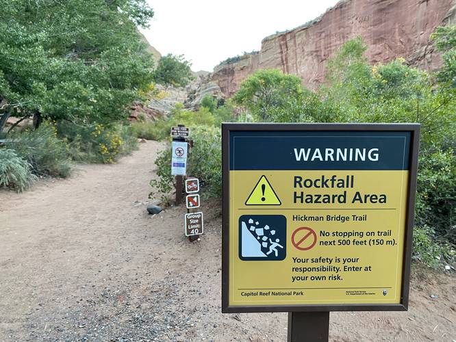
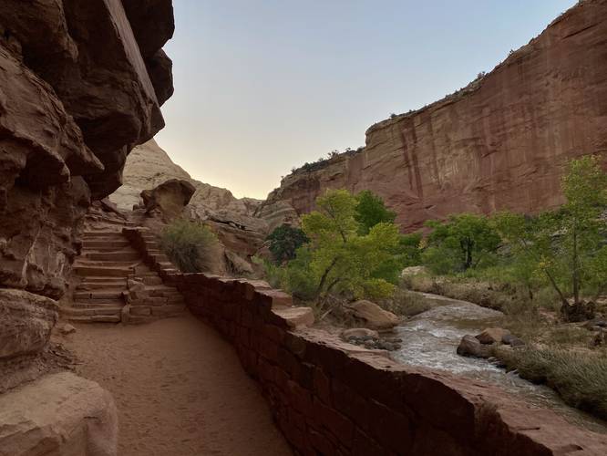
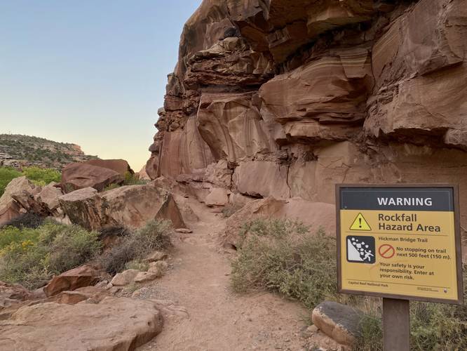
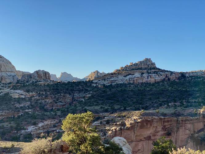
This hike begins at the main parking lot for the Hickman Bridge Trail and follows the dirt path along a rockfall for the first 0.1-miles. Note that due to random chance of rockfalls happening, hikers should never stop during this 500-foot long section of trail; however, this part of the trail is very scenic as it brings you alongside the Fremont River with beautiful stone steps and fencing that ascends the bedrock. On the eastern side of the rockfall's boundaries, hikers will find a few switchbacks that make their way up the hill. Along the way, hikers will begin to get more views eastward, down the canyon along UT-24, of Capitol Reef's cliffs. Soon, the towering rock reefs of Capitol Reef National Park quickly begin to fill-in the nearby distance overhead - during sunrise these towering rock cliffs begin to slowly light up as the sun makes its way around to them.
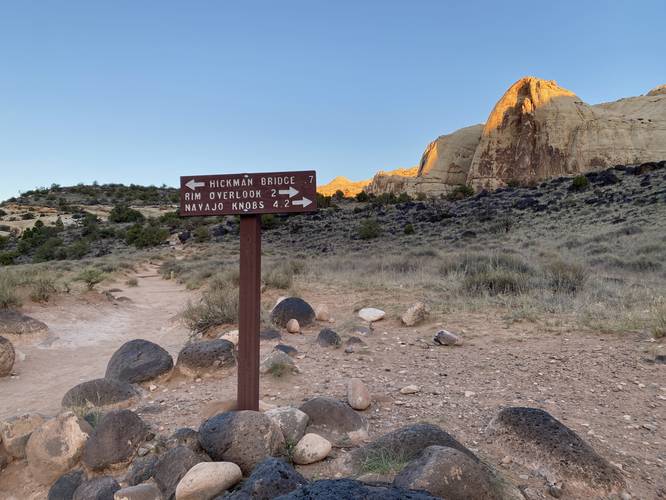
Keep Left - Mile 0.3
At mile 0.3, hikers will find a sign (with arrows) for the Hickman Bridge. Keep left at this trail junction.
Canyon View - Mile 0.5
Around mile 0.5, hikers will reach a part in the trail where it begins to dip down into the canyon. Before descending, you can hike off-trail for ~20 feet to get a view of the rocky dry wash canyon that the trail leads into. From here, you can get interesting views of the nearby rock cliffs and funky natural rock formations that have been carved out by water over eons.
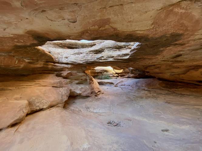
Nel Johnson Natural Bridge / Temporary Waterfalls / Potholes - Mile 0.65
Around mile 0.65, hikers will reach a miniature natural bridge arch, labeled on some maps as the "Nel Johnson Natural Bridge". This natural bridge is a prime example of how the Hickman Bridge was formed over time - hikers will notice there are two natural bridges along with at least a couple of large potholes. The potholes are usually filled with a bit of water, especially after rainfall, and these potholes will eventually erode over time enough to form new natural bridges. During heavy rainstorms or seasonal snow melt, these potholes become waterfalls. As the water flows through these natural bridges, it erodes more rock and sand, creating larger bridges over time.
Loop Junction - 0.75
At mile 0.75, hikers will reach the loop (lollipop) junction for the Hickman Bridge. This GPS track heads left to hike the loop clockwise.
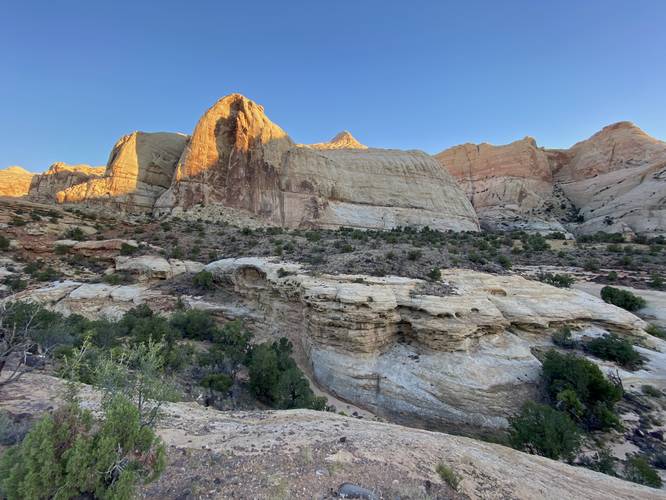
Capitol Reef View - Mile 0.8
At mile 0.8, hikers will reach a view into Capitol Reef National Park from the ridge of the reef (rock barrier) you just hiked up from the parking lot. While this view sits above UT-24, it's fairly quiet and thus hikers will find a peaceful and relaxing vista point to enjoy before continuing onward.
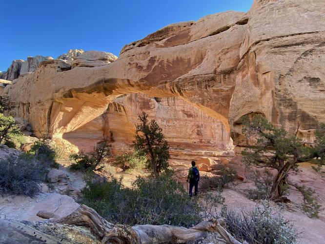
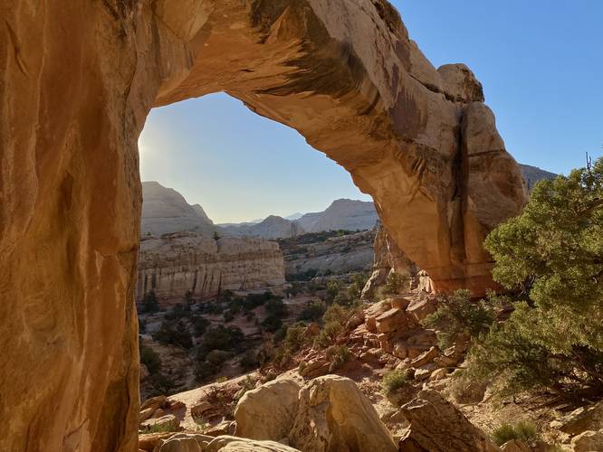
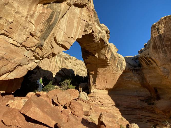
Hickman Bridge Views - Mile 0.9 to 1
Around mile 0.9, hikers will quickly hike up to the Hickman Bridge where it'll come into plain view. You might even hike right up to it before you notice the massive arch, as the trail skirts next to the rock cliff's edge. At mile 0.9, hikers will get a neat view of the Hickman Bridge from the western side. Due to the rock cliffs in the distance, you can't see much sky from this viewpoint, so it helps to move around a bit. There's a short spur (out-and-back) trail that leads through some large boulders to the northern side of the Hickman Bridge - here you can get stunning views of the natural bridge with the sky and more rock barrier reefs of Capitol Reef National Park in the background. The trail the leads under the Hickman Bridge to head south to complete the loop - along the way, hikers will get even more views on your way out.
Hiking Out - Mile 1 to 1.8
After visiting the Hickman Bridge, the hike out follows the same trail you hiked to reach the bridge, aside from completing the loop first. Along the loop portion, be sure to look back from time to time to get different views of the bridge before it's out of sight - or look down into the canyon's dry wash to see more rock formations like potholes or completely dried-up slide waterfalls. Last, remember to keep moving through the rockfall to ensure your own safety during the last 0.1-miles of the trail to reach parking.
Parking
Hikers will find a large parking lot at the coordinates provided. The lot is large enough to fit just over a dozen vehicles if not a bit more. There's overflow parking located within the lot (do not block the flow of traffic) and along UT-24. This parking lot fills up very quickly, especially during the early morning as many hikers wish to explore before the desert heat / sun hits.
Pets
Dogs are not allowed on this trail.
Warnings
Flash flooding: This trail follows a dry wash (dry creek bed) and thus flash flooding is a common occurrence from July through September. Flash flooding happens after heavy rainfall but just a 1/2 inch of rainfall can cause flash floods here. Always pay attention to local weather before heading out, especially upstream from where you plan on hiking, to avoid any/all flash flooding. Check with the local ranger station or park station to understand more about current flash flood conditions before venturing into this type of terrain.
Sun exposure: This trail has very little shade during mid-day as the sun beats down directly on the trail. Bring plenty of water (1-gallon per person per day) and sun protection if planning to hike during mid-day sun, otherwise it's smart to plan to hike in the early morning or evening to avoid the desert's heat. If hiking this trail during the morning or evening, you'll receive some shade from the canyon walls.
Rattlesnakes: Rattlesnakes call this area home and could be found out on the trail during warm/hot months. If found, please give these snakes plenty of space.
Rockfalls: This trail passes under large cliffs that sometimes have rockfall activity, especially within the first 0.1-miles (500-feet) of the trail. Within rockfall areas, hikers should never stop moving to ensure their own safety.
Hike Description
This hike begins at the main parking lot for the Hickman Bridge Trail and follows the dirt path along a rockfall for the first 0.1-miles. Note that due to random chance of rockfalls happening, hikers should never stop during this 500-foot long section of trail; however, this part of the trail is very scenic as it brings you alongside the Fremont River with beautiful stone steps and fencing that ascends the bedrock. On the eastern side of the rockfall's boundaries, hikers will find a few switchbacks that make their way up the hill. Along the way, hikers will begin to get more views eastward, down the canyon along UT-24, of Capitol Reef's cliffs. Soon, the towering rock reefs of Capitol Reef National Park quickly begin to fill-in the nearby distance overhead - during sunrise these towering rock cliffs begin to slowly light up as the sun makes its way around to them.
Keep Left - Mile 0.3
At mile 0.3, hikers will find a sign (with arrows) for the Hickman Bridge. Keep left at this trail junction.
Canyon View - Mile 0.5
Around mile 0.5, hikers will reach a part in the trail where it begins to dip down into the canyon. Before descending, you can hike off-trail for ~20 feet to get a view of the rocky dry wash canyon that the trail leads into. From here, you can get interesting views of the nearby rock cliffs and funky natural rock formations that have been carved out by water over eons.
Nel Johnson Natural Bridge / Temporary Waterfalls / Potholes - Mile 0.65
Around mile 0.65, hikers will reach a miniature natural bridge arch, labeled on some maps as the "Nel Johnson Natural Bridge". This natural bridge is a prime example of how the Hickman Bridge was formed over time - hikers will notice there are two natural bridges along with at least a couple of large potholes. The potholes are usually filled with a bit of water, especially after rainfall, and these potholes will eventually erode over time enough to form new natural bridges. During heavy rainstorms or seasonal snow melt, these potholes become waterfalls. As the water flows through these natural bridges, it erodes more rock and sand, creating larger bridges over time.
Loop Junction - 0.75
At mile 0.75, hikers will reach the loop (lollipop) junction for the Hickman Bridge. This GPS track heads left to hike the loop clockwise.
Capitol Reef View - Mile 0.8
At mile 0.8, hikers will reach a view into Capitol Reef National Park from the ridge of the reef (rock barrier) you just hiked up from the parking lot. While this view sits above UT-24, it's fairly quiet and thus hikers will find a peaceful and relaxing vista point to enjoy before continuing onward.
Hickman Bridge Views - Mile 0.9 to 1
Around mile 0.9, hikers will quickly hike up to the Hickman Bridge where it'll come into plain view. You might even hike right up to it before you notice the massive arch, as the trail skirts next to the rock cliff's edge. At mile 0.9, hikers will get a neat view of the Hickman Bridge from the western side. Due to the rock cliffs in the distance, you can't see much sky from this viewpoint, so it helps to move around a bit. There's a short spur (out-and-back) trail that leads through some large boulders to the northern side of the Hickman Bridge - here you can get stunning views of the natural bridge with the sky and more rock barrier reefs of Capitol Reef National Park in the background. The trail the leads under the Hickman Bridge to head south to complete the loop - along the way, hikers will get even more views on your way out.
Hiking Out - Mile 1 to 1.8
After visiting the Hickman Bridge, the hike out follows the same trail you hiked to reach the bridge, aside from completing the loop first. Along the loop portion, be sure to look back from time to time to get different views of the bridge before it's out of sight - or look down into the canyon's dry wash to see more rock formations like potholes or completely dried-up slide waterfalls. Last, remember to keep moving through the rockfall to ensure your own safety during the last 0.1-miles of the trail to reach parking.
Parking
Hikers will find a large parking lot at the coordinates provided. The lot is large enough to fit just over a dozen vehicles if not a bit more. There's overflow parking located within the lot (do not block the flow of traffic) and along UT-24. This parking lot fills up very quickly, especially during the early morning as many hikers wish to explore before the desert heat / sun hits.
Pets
Dogs are not allowed on this trail.
Warnings
Flash flooding: This trail follows a dry wash (dry creek bed) and thus flash flooding is a common occurrence from July through September. Flash flooding happens after heavy rainfall but just a 1/2 inch of rainfall can cause flash floods here. Always pay attention to local weather before heading out, especially upstream from where you plan on hiking, to avoid any/all flash flooding. Check with the local ranger station or park station to understand more about current flash flood conditions before venturing into this type of terrain.
Sun exposure: This trail has very little shade during mid-day as the sun beats down directly on the trail. Bring plenty of water (1-gallon per person per day) and sun protection if planning to hike during mid-day sun, otherwise it's smart to plan to hike in the early morning or evening to avoid the desert's heat. If hiking this trail during the morning or evening, you'll receive some shade from the canyon walls.
Rattlesnakes: Rattlesnakes call this area home and could be found out on the trail during warm/hot months. If found, please give these snakes plenty of space.
Rockfalls: This trail passes under large cliffs that sometimes have rockfall activity, especially within the first 0.1-miles (500-feet) of the trail. Within rockfall areas, hikers should never stop moving to ensure their own safety.