Hetchell's Tooth Cliffs Hike at State Game Lands 141 in Jim Thorpe, Pennsylvania is a difficult 2.8-mile out-and-back hike that leads to several views of the Lehigh Gorge including Packer's Point and Hetchell's Tooth Cliffs.
Trails
This hike follows one named trail: Overlook Trail (red blazes).
Hike Description
This hike begins at the Glen Onoko River Access at Lehigh Gorge State Park and heads-in along the staircase located on the southwest corner of the parking lot. Hikers will head down the stairs, then turn right to hike under the bridges. The trail will then head uphill to reach a large wooden sign labeled "Welcome to Glen Onoko Trail" -- note that the Glen Onoko Trail has been closed for years now, so please stay off of that route for your own safety. At the trail sign, take a right-hand turn to hike the red blazes of the Overlook Trail as it ascends the mountain along the Lehigh Gorge.
Ascending to Packer's Point Overlook - Mile 0.1 to 0.77
The hike up to Packer's Point is fairly short, about 0.67 miles at most, but there are a lot of relatively steep sections that slow you down. Hikers also need to be aware of the trail junction at mile 0.5 -- keep right to continue up the steep red-blazed Overlook Trail to reach Packer's Point.
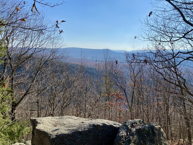
Packer's Point Overlook - Mile 0.77
Around mile 0.77, hikers will reach the first overlook along the hike -- Packer's Point Overlook. Packer's Point is a very large boulder that sits at the very-top of the trail, where the mountain grade levels out from the steep climb up. As of November 2023, Packer's Point is mostly overgrown by the surrounding trees. During colder months, when the leaves are off of the trees, this is a nice vista to take-in the sights of the surrounding Jim Thorpe, PA area along with the Lehigh Gorge, but it's not the nicest view along the trail -- for the best views, keep hiking.
Once at the top of the mountain, the Overlook Trail levels out quite a bit. The only downside to this trail are the endless rocks that litter the forest floor, which makes for annoying and slightly difficult flat-ground hiking. Along the way are a couple of view points that hikers can stop at before reaching Hetchell's Tooth Cliffs.
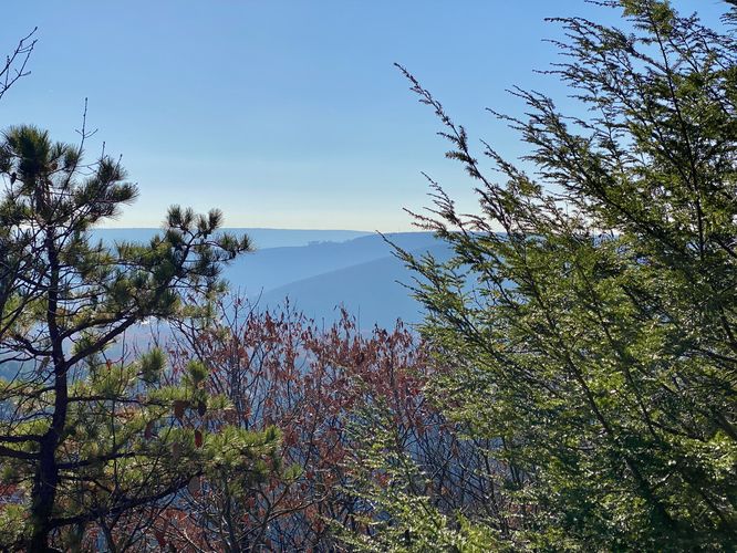
Off-Trail Vista #1 - Mile 1
Around mile 1, hikers will find an off-trail view of the nearby Lehigh Gorge mountain slopes. While this vista is a bit obstructed by the neighboring evergreens, it's still a nice spot to checkout on your hike to Hetchell's Tooth Cliffs.
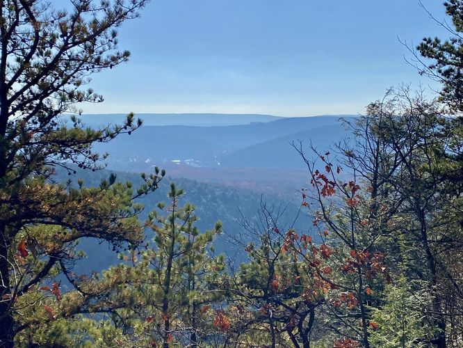
Off-Trail Vista #2 - Mile 1.2
At mile 1.2, hikers will find another off-trail vista located downhill amongst the large boulders and rocks. Be careful as you traverse through the area as there are plenty of hidden pockets that can trap your feet. The view can be found at the last large boulder -- stand up on it to get the best view out from the mountain side. Again, there are better views of the Lehigh Gorge waiting at Hetchell's Tooth Cliffs, but this is a fun off-trail spot to checkout too.
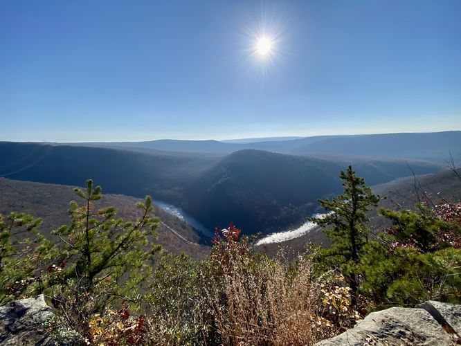
Hetchell's Tooth Cliffs - Mile 1.4
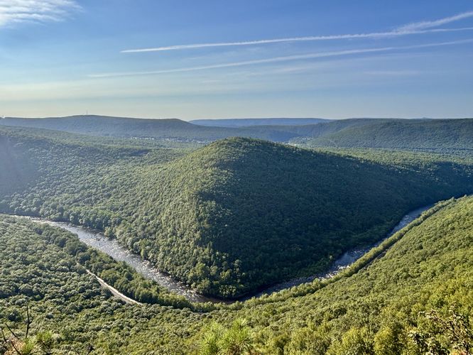
Around mile 1.38, hikers will reach an open trail junction -- a right-hand turn here will lead hikers directly to Hetchell's Tooth Cliffs and the edge of the Lehigh Gorge at mile 1.4. At Hetchell's Tooth Cliffs, hikers will find panoramic views of the Lehigh Gorge from high above the Lehigh River. Views include the Lehigh Gorge, Lehigh River, the town of Jim Thorpe and mountains in the distance. The Lehigh River takes a sharp bend just below your feet, which makes for a dramatic view of the gorge. Watch your step as some of the drop-offs from these cliffs is pretty far.
The hike out follows the same path as the hike in, however, hiking down the mountain is a bit more difficult than hiking up was -- in terms of muscle-use and footing on the rock-like steps that make up portions of this mountainous trail. Take your time and watch your step as you hike along the rocky terrain. Hikers will finally reach the parking lot for a difficult 2.8-mile out-and-back hike.
Parking
Hikers will find a very large parking lot at the coordinates provided, located at the Glen Onoko River Access at Lehigh Gorge State Park. The lot is large enough to fit a few dozen vehicles with overflow parking located on the entrance road just down the street.
Pets
Dogs are allowed only if leashed and must be cleaned up after.
Warning
Steep cliffs: This hike leads to steep cliffs. Watch your step and hike at your own risk.
Rocky terrain: This hike leads through areas of very rocky terrain. Trekking poles can help tremendously while hiking throug uneven or rocky terrain like this. Watch your step and hike at your own risk.
Trails
This hike follows one named trail: Overlook Trail (red blazes).
Hike Description
This hike begins at the Glen Onoko River Access at Lehigh Gorge State Park and heads-in along the staircase located on the southwest corner of the parking lot. Hikers will head down the stairs, then turn right to hike under the bridges. The trail will then head uphill to reach a large wooden sign labeled "Welcome to Glen Onoko Trail" -- note that the Glen Onoko Trail has been closed for years now, so please stay off of that route for your own safety. At the trail sign, take a right-hand turn to hike the red blazes of the Overlook Trail as it ascends the mountain along the Lehigh Gorge.
Ascending to Packer's Point Overlook - Mile 0.1 to 0.77
The hike up to Packer's Point is fairly short, about 0.67 miles at most, but there are a lot of relatively steep sections that slow you down. Hikers also need to be aware of the trail junction at mile 0.5 -- keep right to continue up the steep red-blazed Overlook Trail to reach Packer's Point.
Packer's Point Overlook - Mile 0.77
Around mile 0.77, hikers will reach the first overlook along the hike -- Packer's Point Overlook. Packer's Point is a very large boulder that sits at the very-top of the trail, where the mountain grade levels out from the steep climb up. As of November 2023, Packer's Point is mostly overgrown by the surrounding trees. During colder months, when the leaves are off of the trees, this is a nice vista to take-in the sights of the surrounding Jim Thorpe, PA area along with the Lehigh Gorge, but it's not the nicest view along the trail -- for the best views, keep hiking.
Once at the top of the mountain, the Overlook Trail levels out quite a bit. The only downside to this trail are the endless rocks that litter the forest floor, which makes for annoying and slightly difficult flat-ground hiking. Along the way are a couple of view points that hikers can stop at before reaching Hetchell's Tooth Cliffs.
Off-Trail Vista #1 - Mile 1
Around mile 1, hikers will find an off-trail view of the nearby Lehigh Gorge mountain slopes. While this vista is a bit obstructed by the neighboring evergreens, it's still a nice spot to checkout on your hike to Hetchell's Tooth Cliffs.
Off-Trail Vista #2 - Mile 1.2
At mile 1.2, hikers will find another off-trail vista located downhill amongst the large boulders and rocks. Be careful as you traverse through the area as there are plenty of hidden pockets that can trap your feet. The view can be found at the last large boulder -- stand up on it to get the best view out from the mountain side. Again, there are better views of the Lehigh Gorge waiting at Hetchell's Tooth Cliffs, but this is a fun off-trail spot to checkout too.
Hetchell's Tooth Cliffs - Mile 1.4
Around mile 1.38, hikers will reach an open trail junction -- a right-hand turn here will lead hikers directly to Hetchell's Tooth Cliffs and the edge of the Lehigh Gorge at mile 1.4. At Hetchell's Tooth Cliffs, hikers will find panoramic views of the Lehigh Gorge from high above the Lehigh River. Views include the Lehigh Gorge, Lehigh River, the town of Jim Thorpe and mountains in the distance. The Lehigh River takes a sharp bend just below your feet, which makes for a dramatic view of the gorge. Watch your step as some of the drop-offs from these cliffs is pretty far.
The hike out follows the same path as the hike in, however, hiking down the mountain is a bit more difficult than hiking up was -- in terms of muscle-use and footing on the rock-like steps that make up portions of this mountainous trail. Take your time and watch your step as you hike along the rocky terrain. Hikers will finally reach the parking lot for a difficult 2.8-mile out-and-back hike.
Parking
Hikers will find a very large parking lot at the coordinates provided, located at the Glen Onoko River Access at Lehigh Gorge State Park. The lot is large enough to fit a few dozen vehicles with overflow parking located on the entrance road just down the street.
Pets
Dogs are allowed only if leashed and must be cleaned up after.
Warning
Steep cliffs: This hike leads to steep cliffs. Watch your step and hike at your own risk.
Rocky terrain: This hike leads through areas of very rocky terrain. Trekking poles can help tremendously while hiking throug uneven or rocky terrain like this. Watch your step and hike at your own risk.