Loading...

WINTER SALE! 50% OFF Supporter Accounts — now through January 31st. Learn More.

Hell's Hollow Trail

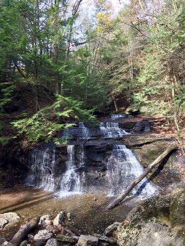
Hell's Hollow Trail at McConnell's Mill State Park in Ellwood City, Pennsylvania is an easy 1.2 mile out-and-back hike down to Hell's Hollow Falls and back. Hell's Hollow Falls is about 15 feet tall and about 20 feet wide, but cascades down the hill for a further distance before reaching the true falls. The hike to Hell's Hollow Falls is short and flat, making this a quick day hike; however, getting down to the falls is not wheelchair accessible. Just before you reach the bottom of the falls, the trail starts heading downhill to a staircase and the trail can be slippery, because the trail is mostly rocky.

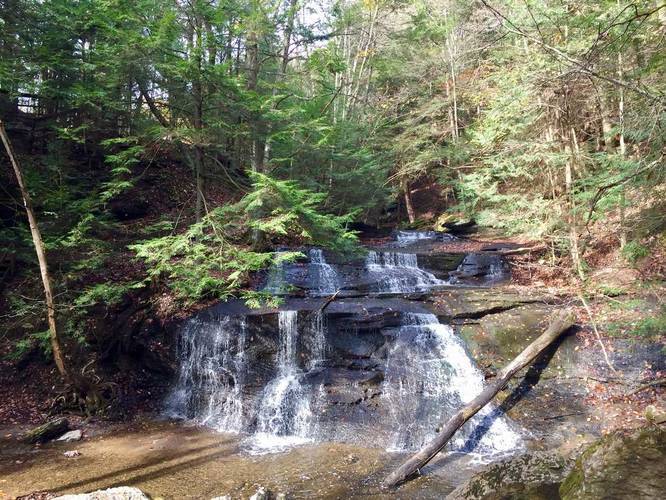
Follow the staircase down to the creek and use the large rocks in the creek to cross it. On the other side of the creek  you can get an excellent view of Hell's Hollow Falls and the creek that cascades down the large rock formation just before the falls.

This is one of the best trails in McConnell's Mill State Park and is a moderately-trafficked trail. This trail is much more popular on weekends and there's often at least one group of people at the falls at all times on the weekends; however, you can certainly plan a secluded visit to Hell's Hollow Falls during the middle of the week.
Explore 35 trails near Ellwood City, PA

Know Before You Go

  • Hell's Hollow Trail is a short, easy 1.2-mile hike to a scenic waterfall within McConnell's Mill State Park.
  • Access to the base of Hell's Hollow Falls involves a potentially slippery, rocky descent and creek crossing.
  • The trail is popular, especially on weekends, but weekday visits may offer more solitude.
Interactive topographic map for Hell's Hollow Trail located in Ellwood City, PA. Click the "View Map" button to load GPS coordinates and trail markers.
Get directions
Distance
1.2 mi
Difficulty
Easy
Type
Out-and-Back
Est. Time
36 min
Elev. Gain
162'
Rating
0.0
Added
September 13, 2015
Updated
December 31, 2017

Weather Forecast

Loading...
Total Change
59'
Ascent
162'
Descent
159'
Loading...

Download the GPX Data for Offline Use

Supporters get exclusive access to download trail routes to the MyHikes app for offline use. Stay prepared on your adventure, even without an internet connection! Become a Supporter today to unlock this feature and hike with confidence.

Download Hell's Hollow Trail GPX Data to the MyHikes Mobile App

Features

Dogs
Waterfalls
Water Source

Points of interest

  1. Parking

    40.931389, -80.240067
  2. Main Trailhead

    40.931349, -80.239845

Safety information

For your own safety: plan ahead, let someone know where you'll be, and hike at your own risk.

Availability

Summer

Surface type

Dirt

Trip Reports (Reviews)

Your opinion matters! Be the first to rate this trail.

Ready to help fellow hikers? Add a trip report to share your experience and provide valuable insights for other hikers!

1.2 miles / 1.9 km
August 12, 2019
Easy hike, fairly crowded
Hiking
1.2 miles / 1.9 km
November 04, 2017
Hiking
1.2 miles / 1.9 km
November 04, 2017
Hiking
No community routes found. To add your own hike as a Community Route for this Trail guide, leave a Trip Report with an attached GPX file.

Popular categories

Scenic mountain view representing vista trails
Vista trails
Scenic gorge of cascades representing waterfall trails
Waterfall hikes
Rugged mountain terrain representing summit trails
Summit trails
Scenic mountain view representing dog-friendly trails
Dog-friendly
Scenic campsite with a view representing camping trails
Camping trails
Appalachian Trail logo representing A.T. hikes
A.T. hikes

You May Also Like

New York's Best Waterfalls - Whether you're planning a day hike, roadside stop, or a leisurely short walk, this guide provides hikers, travelers, and locals alike with 63 different locations to over 100 scenic waterfalls to help plan your next adventure!
Explore

New York's Best Waterfalls

Whether you're planning a day hike, roadside stop, or a leisurely short walk, this guide provides hikers, travelers, and locals alike with 63 different locations to over 100 scenic waterfalls to help plan your next adventure!

Read
🍪 We use cookies to learn about site usage and to serve map tiles. You may block cookies manually in the browser. By continuing you agree. Learn more