Located on the northwest slopes of Mt. Baker sits the Heliotrope Ridge Trail leads to a stunning viewpoint along the Coleman Glacier and connects to classic climbing routes along the way.
This moderate 5.2-mile out-and-back hike follows the Heliotrope Ridge Trail as it ascends ~1,700-feet to reach the Coleman Glacier, passing waterfalls like Upper Kulshan Creek Falls, Heliotrope Falls, old-growth trees, and vistas along the way.
Steep terrain: This hike leads to a moraine along the edge of Coleman Glacier and features sheer drop-offs that plummet over 60-feet. Keeping back from the edge of the moraine is best for your own safety as the soil there is relatively loose.
Coleman Glacier: For hikers that wish to traverse the ice of Coleman Glacier, you must have glacier travel experience and alpine climbing gear to ensure your own safety. The glacier is covered in visible and hidden crevasses that pose extreme risk for anyone attempting to walk on the glacier.
This moderate 5.2-mile out-and-back hike follows the Heliotrope Ridge Trail as it ascends ~1,700-feet to reach the Coleman Glacier, passing waterfalls like Upper Kulshan Creek Falls, Heliotrope Falls, old-growth trees, and vistas along the way.
Hiking the Heliotrope Ridge Trail
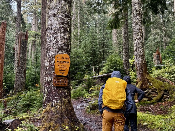
This hike begins at the main trailhead located along NF 39 just south of Glacier, Washington at the parking coordinates provided (48.802313, -121.895594) where the trail leads through an old-growth forest full of moss, ferns, and small waterfalls that tumble down Grouse Creek. Just 0.1-miles into the hike, you'll find a wooden footbridge spanning the creek with small cascades of up to 10-feet tall spilling down Mt. Bakers low-altitude slopes. Just beyond the footbridge sits the Mt. Baker Wilderness boundary, marked by the National Forest sign.Old-Growth Tree - Mile 0.5
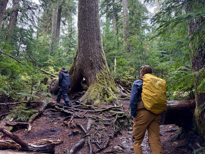
After passing the Mt. Baker Wilderness sign, the trail winds through the forest along a couple of short switchbacks, along one of the steepest elevation grades along the hike before it reaches an old-growth tree at mile 0.5. This massive tree once grew up and over a wide stump, leaving a cave-like structure below its roots where hikers can take shelter from heavy rain or hop inside for a photo-op on the way toward Coleman Glacier.60-Foot Tall Waterfall - Mile 1.35
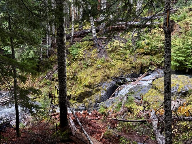
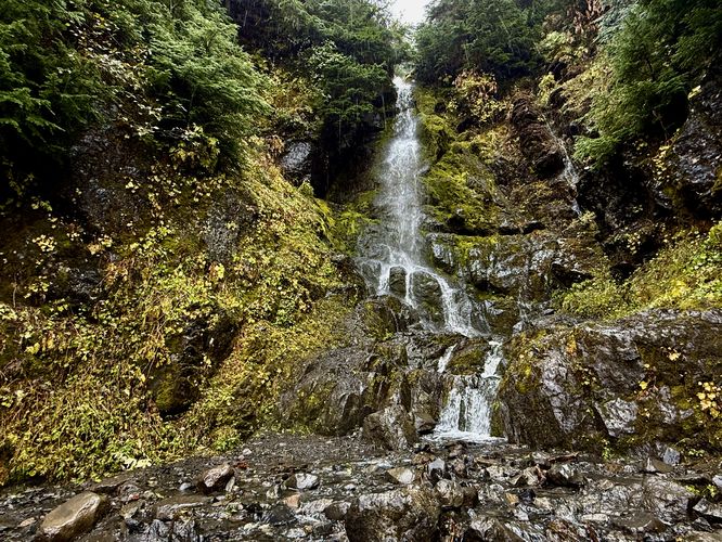
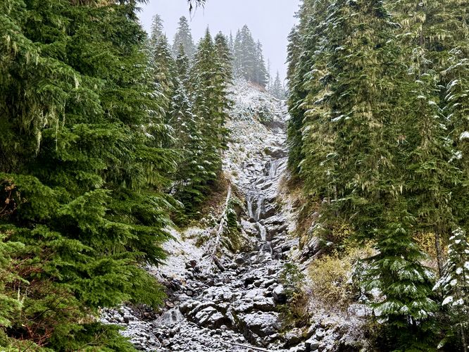
After passing the old-growth tree, the hike up becomes a bit more gradual as the trail passes through the moss-covered, fern-filled slopes of Mt. Baker until reaching a ~60-foot tall waterfall at mile 1.35. This cascade spills down several tiers of cliff sides before the stream crosses the trail and makes for a perfect short break along the hike. Just beyond the waterfall sits a nice vista of the surrounding mountains and foothills.Kulshan Creek Waterfalls - Mile 1.45 & 1.9
Just up the trail, near mile 1.45 sits a creek crossing where you'll have to rock-hop or get your feet a little wet to cross through the shallow waters of Kulshan Creek. Just below the trail's creek crossing sits the ~10-foot tall Lower Kulshan Creek Falls as it spills down the mountainside. The trail then makes a wide curve through the forest before heading back uphill, following several switchbacks, and leads to a beautiful view of the ~70-foot tall Upper Kulshan Creek Falls located near mile 1.9. This is yet another great spot to take a short break to enjoy more of the natural beauty of Mt. Baker's water features on its northwestern slopes.Foothill Views & Trail Junction - Mile 2.25 to 2.3
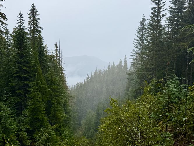
After you pass the Kulshan Creek waterfalls, the Heliotrope Ridge Trail provides hikers with a couple of vista points near mile 2.25 and 2.3. Both views feature more foothills and low-elevation mountains that sit to the north of Mt. Baker. In between sits the Hogsback Route, so simply keep left (hiking up) to stay on the Heliotrope Ridge Trail.Heliotrope Falls & Creek Crossings - Mile 2.4 to 2.55
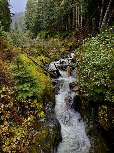
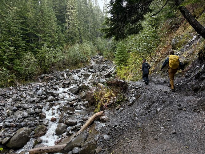
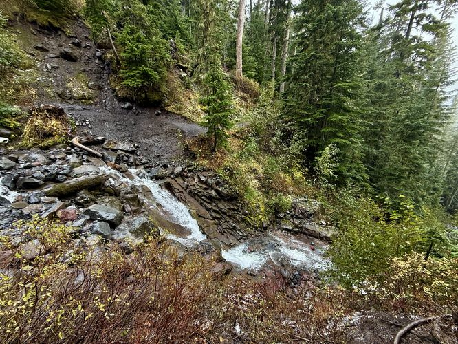
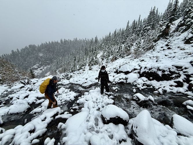
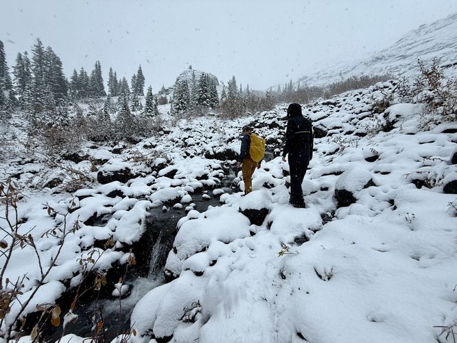
The trail eventually reaches glacier-fed creeks at mile 2.4 where you'll find the scenic, but short Heliotrope Falls (approx. 15 feet tall) along with a creek crossing. Here, the water level can vary based on the level of snow and glacier melt. During our hike in mid-October, this creek was fairly challenging to cross. Just beyond, the trail crosses one more series of creeks that fan out, making for about 2 or 3 creek crossings in total, but were somewhat easier than the creek crossing at mile 2.4.Coleman Glacier Viewpoint - Mile 2.6
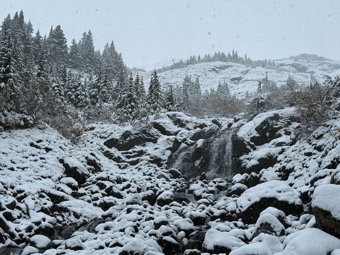
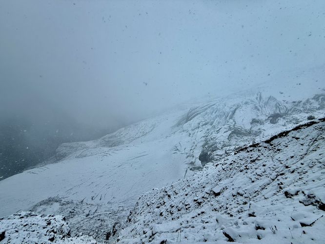
After crossing the last creek at mile 2.55, the trail leads back uphill to reach the moraine of the Coleman Glacier where you'll find a stunning view of the massive slow-moving ice field as it clings to Mt. Baker's slopes. Watch your step along the steep slopes of the moraine as you enjoy views of the glacier from ~80-feet above the ice below. Depending on the crevasses when you visit, you may even find more waterfalls. On our visit, we found two large waterfall inside of Coleman Glacier tumbling through the ice and each appeared to be well-over 50-feet tall. The water crashes through the ice and disappears back into the glacier, forming tunnels for hidden creeks to flow. Note that for hikers with no alpine gear or glacier travel experience, stay on the moraine for your own safety as the Coleman Glacier is filled with hidden crevasses and fissures.Hiking Out - Mile 2.6 to 5.2
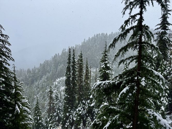
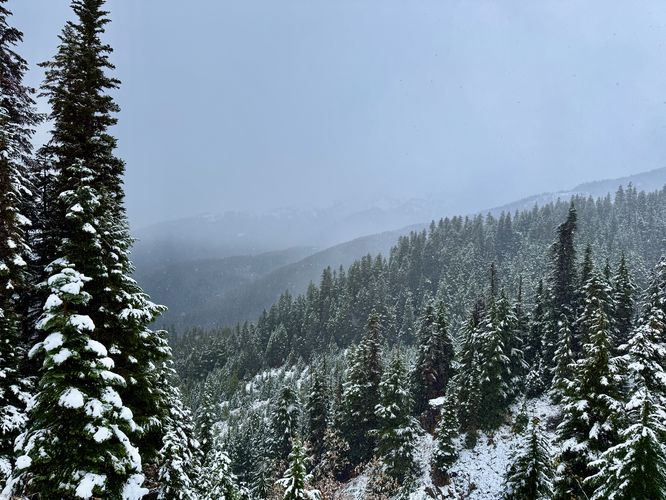
After enjoying the views of the glacier, chilling out, and having a snack, the hike back begins. The hardest part of the hike back to the trailhead from Coleman Glacier are the two immediate creek crossings - this time located at mile 2.65 and 2.8. On your way down be sure to enjoy the views and waterfalls as you make your way back down the low-elevation slopes of Mt. Baker. During our hike, we started in the rain and it gradually turned into snow as we approached the 5,000-foot altitude line and on our way out we hiked out of the snow and back into the rain. Depending on the weather and cloud cover, you might have better views than we did, but regardless the tumbling cascades and vistas along the trail make for enjoyable stops as you make your way back to the trailhead. After passing the old-growth tree, wilderness boundary sign, and the small waterfalls of Grouse Creek, you'll end the hike at mile 5.2 back at the trailhead.Parking
Hikers will find parking at the coordinates provided located (48.802313, -121.895594) on NF 39. The parking lot is large enough to fit a couple dozen vehicles as of October 2025.Pets
Dogs are allowed if leashed and must be cleaned up after.Warning
Creek crossings: The creek crossings located along this trail are relatively easy during low snow and glacier melt. During the Spring especially during warmer months when glacier melt is high, the creek crossing may be more difficult. Trekking poles and experience are recommended.Steep terrain: This hike leads to a moraine along the edge of Coleman Glacier and features sheer drop-offs that plummet over 60-feet. Keeping back from the edge of the moraine is best for your own safety as the soil there is relatively loose.
Coleman Glacier: For hikers that wish to traverse the ice of Coleman Glacier, you must have glacier travel experience and alpine climbing gear to ensure your own safety. The glacier is covered in visible and hidden crevasses that pose extreme risk for anyone attempting to walk on the glacier.