Loading...

๐ŸŽ† 50% off 4th of July sale on Supporter Accounts โ€” now through July 6! Learn More.

Hector Falls

Directions
Map
Pictures
Send to App
Distance:
0 Miles / 0 km
Type:
Out-and-Back
Difficulty:
Easy
Time to Hike:
~5 minutes
Features:
Surface Type:
Dirt
Town:
Burdett, New York
Directions:
42.417733, -76.866676
Added:
August 04, 2024
Updated:
August 08, 2024
Copy Trail Link Hiking this trail? Send a friend or family member a link to this trail guide for your own safety. Hike at your own risk (disclaimer)
Loading...

Download the Trail Route for Offline Use

Supporters get exclusive access to download trail routes to the MyHikes app for offline use. Stay prepared on your adventure, even without an internet connection! Become a Supporter today to unlock this feature and hike with confidence.

Send to App

Hector Falls

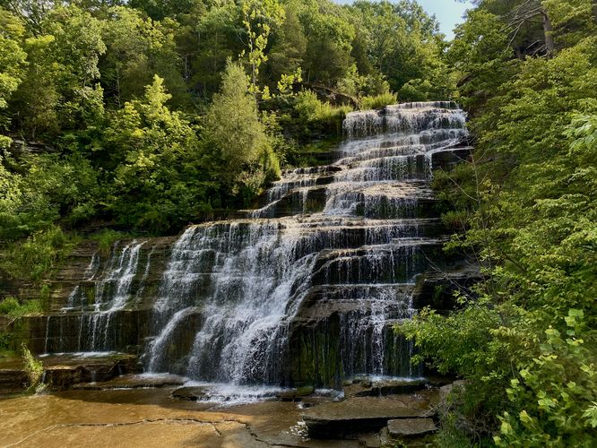
Hector Falls in Burdett, New York is an easy roadside walk to 60-foot tall multi-tiered waterfall known as Hector Falls.

This is not a hike but rather a very short walk. Visitors will find parallel parking along the road on either side of the bridge along NY-414 where they'll ditch their cars to walk along the bridge to a view of Hector Falls. Hector Falls cascades down the hillside at about 60-feet tall in total and includes about five main tiers of cascades.

Parking
Visitors will find parking along NY-414 at the coordinates provided. Parallel parking-only. Watch for traffic moving at ~55mph coming up from behind when you get out of your vehicle as this spot can be very dangerous to exit your car! Parking is legally allowed in the breakdown lane on the sides of the bridge. Do not park on the bridge!

Pets
Dogs are allowed only if leashed and should be cleaned up after.
Explore 89 trails near Burdett, NY
  1. Parking

    42.417733, -76.866676
  2. Main Trailhead

    42.417773, -76.86668
  3. Hector Falls in Burdett NY

    42.418033, -76.866653
    Hector Falls in Burdett NY
No community routes found. To add your own hike as a Community Route for this Trail guide, leave a Trip Report with an attached GPX file.

Hazards

Ticks - Lyme Disease More Info (CDC)

Seasons

All

Weather Forecast

In Burdett, NY

Explore Hiking Trails

You May Also Like

Colorado's Million Dollar Highway - Plan a day's drive adventure along the iconic Million Dollar Highway in Colorado. Explore the best short trails, roadside stops, waterfalls, vistas, ghost towns, and hot springs within a ~6 hour road trip.
Explore

Colorado's Million Dollar Highway

Plan a day's drive adventure along the iconic Million Dollar Highway in Colorado. Explore the best short trails, roadside stops, waterfalls, vistas, ghost towns, and hot springs within a ~6 hour road trip.

Read
Glacier's Going-to-the-Sun Road - Discover the breathtaking beauty of Glacier National Park along the iconic Going-to-the-Sun Road. From stunning roadside stops to picturesque waterfalls and vistas, this engineering marvel offers endless opportunities for exploration.
Explore

Glacier's Going-to-the-Sun Road

Discover the breathtaking beauty of Glacier National Park along the iconic Going-to-the-Sun Road. From stunning roadside stops to picturesque waterfalls and vistas, this engineering marvel offers endless opportunities for exploration.

Read
New York's Best Waterfalls - Whether you're planning a day hike, roadside stop, or a leisurely short walk, this guide provides hikers, travelers, and locals alike with 63 different locations to over 100 scenic waterfalls to help plan your next adventure!
Explore

New York's Best Waterfalls

Whether you're planning a day hike, roadside stop, or a leisurely short walk, this guide provides hikers, travelers, and locals alike with 63 different locations to over 100 scenic waterfalls to help plan your next adventure!

Read

Before you boogie...

Find our trail guides useful? Consider becoming a Supporter to unlock perks!

MyHikes is an indie platform that makes exploring public trails easier for everyone. The platform has no investors, no ads, and is owned and operated by one person, Dave Miller. Dave has personally mapped and written over 1,800 trail guides on MyHikes for the public to explore. MyHikes has helped millions outdoor enthusiasts plan their next adventure.

But it takes a lot of time ๐Ÿ•ฆ, money ๐Ÿ’ฐ, work, and espresso shots โ˜• to run MyHikes, including hiking , mapping , writing , and publishing new trails with high-quality (accurate) information... along with software engineering (coding) the platform like building new features, website and mobile app development (iOS and Android), site maintainance . and much much more.

Supporters unlock website and mobile app perks with an annual one-time payment of $25 (you renew) ๐Ÿ˜Ž๐Ÿ‘. Or you can simply make a Donation of your choice. Otherwise, you can support us by telling your friends about MyHikes - both quick and free ๐ŸŽ‰

Admin user profile picture

Dave Miller
MyHikes Founder