Passing through old growth forest, over the northwest ridge on Hazel Mountain, then descending to Hazel River,
this circuit hike starting on Skyline Drive has a wide diversity of
scenery. The hike also has the added bonus of being one of the less
frequented circuits in this very popular section of the Shenandoah
National Park. The highlight is the waterfall and swimming hole on the upper section of Hazel River, but even on the hottest days the mountain water will be chilly!
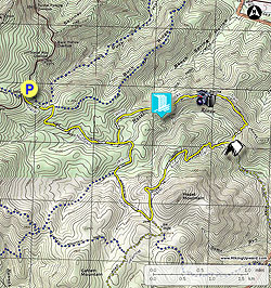
- Mile 0.0 - From the parking area take the yellow blazed Hazel Mountain Trail to the right past a chain gate as it begins its decent towards the valley. Arrive at the intersection of the blue blazed Buck Ridge Trail in 0.44 miles.
- Mile 0.44 - Turn right downhill staying on the Hazel Mountain Trail. Soon the trail will turn back to the left passing through a section of Mountain Laurel. As the trail begins to level out the upper section of Hazel River will become visible in places 200 yards on the right. Continue along the yellow blazed Hazel Mountain Trail to the junction where the White Rocks Trail comes in on the left.
- Mile 1.57 - Continue straight on the yellow blazed Hazel Mountain Trail and shortly cross upper Hazel River. Hazel River is only a small brook at this point. Pass around to the right of a small ridge, then descend to Runyon Run and the intersection of the Catlett Spur Trail.
- Mile 2.19 - Stay left on the yellow blazed Hazel Mountain Trail immediately crossing Runyon Run. The Hazel Mountain Trail will now start a gentle ascent of the southwest slope of Hazel Mountain then reach the junction of the Hazel River Trail on the left in 0.78 miles.
- Mile 2.97 - Turn left on the yellow blazed Hazel River Trail as it climbs the southwestern slope of Hazel Mountain, then pass through a small saddle. Make a sharp turn back to the right, then begin the descent to the valley. The trail will make several switchbacks and cross a feeder run before reaching Hazel River and junction of the White Rocks Trail. The White Rocks Trail turns left upstream with the Hazel River Trail continuing downstream. The only good campsite on the hike is at this intersection. If you are camping, remember that there are no open fires allowed in the Shenandoah National Park, but cooking is allowed on small self contained stoves such as a Jet Boil.
- Mile 4.85 - Turn left upstream on the yellow blazed White Rocks Trail, and soon arrive at the lower and last crossing of Hazel River. This crossing can be challenging and sometimes requires fording if the river is high. After crossing Hazel River the White Rocks Trail becomes very steep for the next 0.3 miles to the ridgeline. For the next 0.3 miles the trail passes over several knolls. Look for a break in the trees on the left, and 2 unmarked side trails on the right marking the White Rocks vista. There are views to the west of Skyline Drive in the distance. On the right/eastern side there are views of the Sperryville Valley. Continue on the White Rocks Trail for another 0.5 miles to the junction of the waterfall side trail.
- Mile 6.63 - Turn left downhill towards the Hazel River, soon the trail becomes very steep for the remaining 0.1 miles to the river. There is a large swimming hole at this point, and 50 yards upstream the main waterfall and small cave. Return back to the White Rocks Trail.
- Mile 6.83 - Turn left on the White Rocks Trail for 0.78 miles to the intersection of the Hazel River Mountain Trail you past earlier.
- Mile 7.61 - Turn right on the Hazel Mountain Trail following it back uphill to the intersection of the Buck Ridge Trail.
- Mile 8.3 - Turn left uphill staying on the Hazel Mountain Trail.
- Mile 8.7 - Arrive back at the parking area on Skyline Drive.