Loading...

Distance:
0.1 Miles / 0.2 km
Type:
Out-and-Back
Difficulty:
Moderate
Time to Hike:
~5 minutes
Features:
Surface Type:
Dirt
Park:
Hawksnest State Park
Town:
Harwich, Massachusetts
Directions:
41.716882, -70.046751
Added:
April 07, 2023
Updated:
April 07, 2023
Loading...
Loading...
27 '

Total Change
27 '

Ascent
27 '

Descent

The Hawksnest Pond Swimming Hole at Hawksnest State Park in Harwich, Massachusetts is a moderate but short 0.1-mile out-and-back trail that leads to quick pond access and during the Summer months, a spot to cool off in the water.

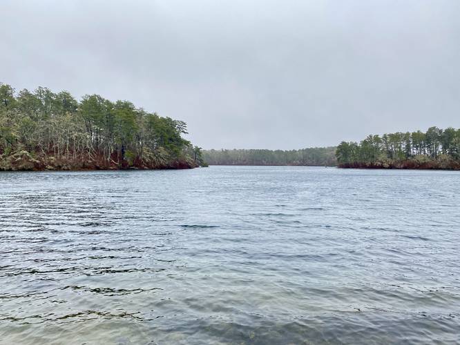
This is not a hike but rather a short hike that leads from Spruce Road down to Hawksnest Pond. The trail begins at the western end of the guardrail on the south side of the road and follows a fairly-steep sloping trail as it leads down toward the water. Not far into the path is an off-shoot trail that leads down an even steeper trail to reach the water. Once at the edge of the water, hikers get a nice view of Hawksnest Pond.

Parking
Visitors will find a large parking turnout that runs the length of Spruce Road near the parking coordinates provided. Park at your own risk; however, this is one of the most-accessible spots to park to access Hawksnest State Park.

Pets
Dogs are allowed only if leashed and must be cleaned up after.

Explore 44 trails near Harwich, MA
  1. Parking

    41.716882, -70.046751
  2. Main Trailhead

    41.716857, -70.046735
  3. View of Hawksnest Pond

    41.716708, -70.046264
    View of Hawksnest Pond
No community routes found. To add your own hike as a Community Route for this Trail guide, leave a Trip Report with an attached GPX file.

Hazards

Ticks - Lyme Disease More Info (CDC)
Poison Ivy/Oak

Seasons

All

Photo Albums

1 Trip Report

No Star-Ratings
Write-up by:
Admin user profile picture
0.1 miles / 0.2 km
Trail added
April 07, 2023
Hiked on
March 31, 2023
Updated on
April 07, 2023

Weather Forecast

In Harwich, MA

Explore Hiking Trails

New Hikes

Battery Warren Trail
1 Mile
1.6 km
Easy
Out-and-Back
Sewee Shell Ring Trail
1.1 Miles
1.8 km
Easy
Loop
Larry's Creek Trail
3.6 Miles
5.8 km
Moderate
Out-and-Back
Angel Falls Loop
2.8 Miles
4.5 km
Moderate
Loop

Before you leave...

MyHikes is an indie web platform aimed to make exploring public trails easier for everyone. The site has no investors and is owned and operated by one person, Dave Miller (Founder & Admin). As the Founder, main contributor, and doer-of-all-things for MyHikes, I share my trips with over-detailed write-ups for fun on a volunteer basis and I believe that public trail information should be available to everyone.

It takes a lot of time 🕦, money 💰, and effort (including espresso shots ☕) to run MyHikes, including hiking , mapping , writing , and publishing new trails with high-quality content... along with building new features, moderating, site maintainance, and app development for iOS and Android . I simply ask that if you find MyHikes' trail guides helpful to please consider becoming a Supporter to help keep the site, iOS, and Android apps available to everyone.

Supporters unlock website and in-app perks with a one-time payment of $25 (you renew) 😎👍. Or you can simply make a Donation of your choice without a MyHikes user account. Otherwise, telling your friends about MyHikes is the next-best thing - both quick and free 🎉

Thanks for visiting MyHikes and have a great hike!️

Admin user profile picture

Dave Miller
MyHikes Founder & Admin