Loading...

🎆 50% off 4th of July sale on Supporter Accounts — now through July 6! Learn More.

Yellow Loop

Directions
Map
Pictures
Send to App
Distance:
0.9 Miles / 1.4 km
Type:
Loop
Difficulty:
Easy
Time to Hike:
~27 minutes
Features:
Surface Type:
Dirt
Park:
Hartwood Acres Park
Town:
Hampton Township, Pennsylvania
Directions:
4100 Middle Rd Allison Park, PA 15101

40.570436, -79.927549
Added:
October 23, 2016
Updated:
April 03, 2019
Copy Trail Link Hiking this trail? Send a friend or family member a link to this trail guide for your own safety. Hike at your own risk (disclaimer)
Loading...
Loading...
69'

Total Change
166'

Ascent
168'

Descent

Download the Trail Route for Offline Use

Supporters get exclusive access to download trail routes to the MyHikes app for offline use. Stay prepared on your adventure, even without an internet connection! Become a Supporter today to unlock this feature and hike with confidence.

Send to App

Yellow Loop

The Yellow Loop Trail at Hartwood Acres Park in Hampton Township, Pennsylvania is a very short 0.9-mile loop trail along the western portion of the park.

Parking for the Hartwood Acre tails is unfortunately to the far west side of the park marked by the address on the map.

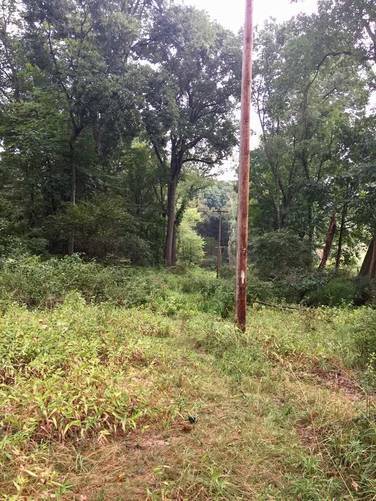
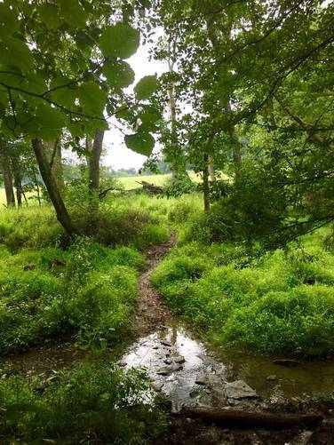
This GPS data brings you along the western portion of this loop before crossing the stream to head north on the eastern section. When heading down the western section of the loop first, make sure to take your immediate left-hand turn onto the trail where there's a large downed tree with a large pile of soil. If you do not take a left, you will not follow the yellow blazes and the blazes are not marked well on that side of the trail.

Parking: Parking at Hartwood Acres is a bit odd since there's only two main places to park. For this trail, you'll want to park at the parking lot on Middle Rd just south of Central Elementary School. This means that you'll need to walk over to the trailhead.

Dogs and biking are allowed here.
Explore 224 trails near Hampton Township, PA
  1. Parking

    40.570436, -79.927549
  2. Main Trailhead

    40.566406, -79.923927
  3. Trail follows the telephone poles

    40.563553, -79.922975
    Trail follows the telephone poles
  4. Trail runs adjacent to neighboring field

    40.563625, -79.921792
    Trail runs adjacent to neighboring field
  5. Creek crossing

    40.563881, -79.921531
    Creek crossing
No community routes found. To add your own hike as a Community Route for this Trail guide, leave a Trip Report with an attached GPX file.

Hazards

Ticks - Lyme Disease More Info (CDC)

Seasons

All

Blaze Color

Yellow

Trip Reports

Trail Guide By:
Admin user profile picture
0.9 miles / 1.4 km
0.9 miles / 1.4 km
August 21, 2020
Hiking
0.9 miles / 1.4 km
August 25, 2017
Dogs Hiking
0.9 miles / 1.4 km
August 25, 2017
Dogs Hiking
0.8 miles / 1.3 km
October 09, 2016
Hiking

Weather Forecast

In Hampton Township, PA

Explore Hiking Trails

You May Also Like

Colorado's Million Dollar Highway - Plan a day's drive adventure along the iconic Million Dollar Highway in Colorado. Explore the best short trails, roadside stops, waterfalls, vistas, ghost towns, and hot springs within a ~6 hour road trip.
Explore

Colorado's Million Dollar Highway

Plan a day's drive adventure along the iconic Million Dollar Highway in Colorado. Explore the best short trails, roadside stops, waterfalls, vistas, ghost towns, and hot springs within a ~6 hour road trip.

Read
New York's Best Waterfalls - Whether you're planning a day hike, roadside stop, or a leisurely short walk, this guide provides hikers, travelers, and locals alike with 63 different locations to over 100 scenic waterfalls to help plan your next adventure!
Explore

New York's Best Waterfalls

Whether you're planning a day hike, roadside stop, or a leisurely short walk, this guide provides hikers, travelers, and locals alike with 63 different locations to over 100 scenic waterfalls to help plan your next adventure!

Read

Before you boogie...

Find our trail guides useful? Consider becoming a Supporter to unlock perks!

MyHikes is an indie platform that makes exploring public trails easier for everyone. The platform has no investors, no ads, and is owned and operated by one person, Dave Miller. Dave has personally mapped and written over 1,800 trail guides on MyHikes for the public to explore. MyHikes has helped millions outdoor enthusiasts plan their next adventure.

But it takes a lot of time 🕦, money 💰, work, and espresso shots ☕ to run MyHikes, including hiking , mapping , writing , and publishing new trails with high-quality (accurate) information... along with software engineering (coding) the platform like building new features, website and mobile app development (iOS and Android), site maintainance . and much much more.

Supporters unlock website and mobile app perks with an annual one-time payment of $25 (you renew) 😎👍. Or you can simply make a Donation of your choice. Otherwise, you can support us by telling your friends about MyHikes - both quick and free 🎉

Admin user profile picture

Dave Miller
MyHikes Founder