Loading...

WINTER SALE! 50% OFF Supporter Accounts — now through January 31st. Learn More.

Wetlands Trail

The Wetlands Trail at Harrison Hills Park, PA, is a 2.3 mile loop hike and one of the best trails in the park.

Despite its name, this trail has more to offer than some of the shorter trails at Harrison Hills. Since the trail encompasses the central area of the park, you wind in and out of different types of forests and some open meadows as well. The trail ascends and descends hills from time to time, but for the most part it's an easy hike.
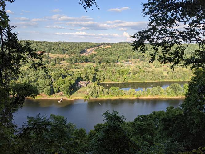
Vista Point
There's a vista point of the Allegheny River along the way that technically lies along the Scout's Trail, but hikers can walk over easily from the Wetland Trail to get a view.
Explore 203 trails near Natrona Heights, PA

Know Before You Go

  • Wetlands Trail is a 2.3-mile loop within Harrison Hills Park in Natrona Heights, PA.
  • The trail offers diverse scenery including forests and meadows, despite its "Wetlands" name.
  • An easily accessible vista point along the Scout's Trail provides views of the Allegheny River.
Interactive topographic map for Wetlands Trail located in Natrona Heights, PA. Click the "View Map" button to load GPS coordinates and trail markers.
Get directions
Distance
2.3 mi
Difficulty
Easy
Type
Loop
Est. Time
1.2 hrs
Elev. Gain
319'
Rating
0.0
Added
November 27, 2015
Updated
August 01, 2020

Weather Forecast

Loading...
Total Change
187'
Ascent
319'
Descent
367'
Loading...

Download the GPX Data for Offline Use

Supporters get exclusive access to download trail routes to the MyHikes app for offline use. Stay prepared on your adventure, even without an internet connection! Become a Supporter today to unlock this feature and hike with confidence.

Download Wetlands Trail GPX Data to the MyHikes Mobile App

Features

Vista / Lookout Point
Dogs
Biking

Points of interest

  1. Parking

    40.654858, -79.703529
  2. Main Trailhead

    40.655284, -79.703995

Safety information

For your own safety: plan ahead, let someone know where you'll be, and hike at your own risk.

Markers

Blaze Color

Green

Availability

All seasons

Surface type

Dirt

Trip Reports (Reviews)

Your opinion matters! Be the first to rate this trail.

Ready to help fellow hikers? Add a trip report to share your experience and provide valuable insights for other hikers!

2.87 miles / 4.6 km
September 10, 2020
Hiking
2.3 miles / 3.7 km
August 01, 2020
Hiking
2.3 miles / 3.7 km
November 15, 2015
Hiking
No community routes found. To add your own hike as a Community Route for this Trail guide, leave a Trip Report with an attached GPX file.

Popular categories

Scenic mountain view representing vista trails
Vista trails
Scenic gorge of cascades representing waterfall trails
Waterfall hikes
Rugged mountain terrain representing summit trails
Summit trails
Scenic mountain view representing dog-friendly trails
Dog-friendly
Scenic campsite with a view representing camping trails
Camping trails
Appalachian Trail logo representing A.T. hikes
A.T. hikes

You May Also Like

New York's Best Waterfalls - Whether you're planning a day hike, roadside stop, or a leisurely short walk, this guide provides hikers, travelers, and locals alike with 63 different locations to over 100 scenic waterfalls to help plan your next adventure!
Explore

New York's Best Waterfalls

Whether you're planning a day hike, roadside stop, or a leisurely short walk, this guide provides hikers, travelers, and locals alike with 63 different locations to over 100 scenic waterfalls to help plan your next adventure!

Read
🍪 We use cookies to learn about site usage and to serve map tiles. You may block cookies manually in the browser. By continuing you agree. Learn more