Hapa Road in Koloa, Hawaii (Kauai) which is part of the Koloa Heritage Trail is an easy 1.3-mile out-and-back trail that follows the old "Hapa Road", which dates back to the late 1800s. This section of the trail is ~1/2 of its entire length - making the whole trail's out-and-back mileage closer to 3-miles in total; however, this half of the trail gives hikers a view of the Kahili Mountain range from the inland valley in Koloa.
Hike Description
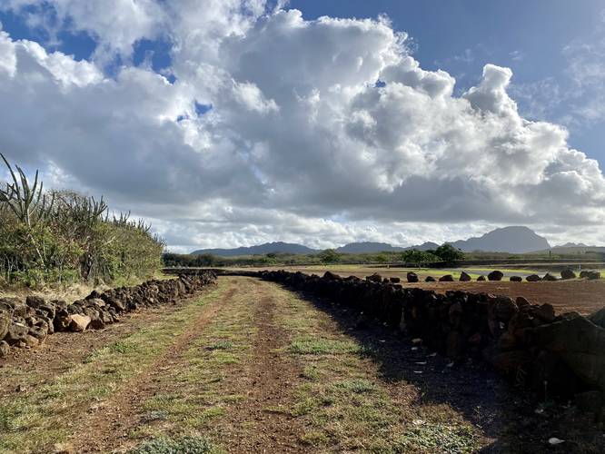
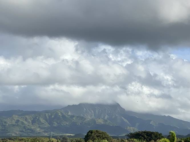
This hike begins at the southern trailhead, located right behind the Little Fish Coffee shop, as of June, 2022. The road follows lava rock walls as it meanders its way north through in inland valleys. The trail eventually begins to follow adjacent to the Kiahuna Plantation Drive, which is lined with palm trees and resort or residential buildings. Not long after, around mile 0.5, the Kahili Mountain range comes into view; however, upon this hike in June, 2022, there's a new resort build built just under these mountain's view. Enjoy the view while it lasts. At this "vista" I stopped the hike and turned back for an easy 1.3-mile out-and-back morning hike.
Parking
Hikers will find parking along the road just behind Little Fish Coffee (as of June, 2022). The parking lot is large enough for a dozen vehicles or more and appears to be used for the shop's overflow parking; however, this parking lot is likely also public parking for the trail.
Pets
Dogs are allowed if leashed. Please clean up after your dog.
History
According to the Koloa Heritage Trail signage at the trailhead, this road dates back to the late 1800s; however, lava rock walls located near Hapa Road indicate the presence of ancient Hawaiians, circa 1200 A.D. Nearby railroad tracks were once used to haul sugar cane to the Koloa Plantation for milling. Hapa Road served as an emergency evacuation road during WWII and at various times, a foot and bicycle path.
Respecting the Land
Hawaiian land is considered sacred to native Hawaiians and many locals, so please stay on-trail, take nothing but photos, and leave nothing but footprints. Respect the locals - don't stay for long and have a backup hike planned in case the parking lot is full.
Hike Description
This hike begins at the southern trailhead, located right behind the Little Fish Coffee shop, as of June, 2022. The road follows lava rock walls as it meanders its way north through in inland valleys. The trail eventually begins to follow adjacent to the Kiahuna Plantation Drive, which is lined with palm trees and resort or residential buildings. Not long after, around mile 0.5, the Kahili Mountain range comes into view; however, upon this hike in June, 2022, there's a new resort build built just under these mountain's view. Enjoy the view while it lasts. At this "vista" I stopped the hike and turned back for an easy 1.3-mile out-and-back morning hike.
Parking
Hikers will find parking along the road just behind Little Fish Coffee (as of June, 2022). The parking lot is large enough for a dozen vehicles or more and appears to be used for the shop's overflow parking; however, this parking lot is likely also public parking for the trail.
Pets
Dogs are allowed if leashed. Please clean up after your dog.
History
According to the Koloa Heritage Trail signage at the trailhead, this road dates back to the late 1800s; however, lava rock walls located near Hapa Road indicate the presence of ancient Hawaiians, circa 1200 A.D. Nearby railroad tracks were once used to haul sugar cane to the Koloa Plantation for milling. Hapa Road served as an emergency evacuation road during WWII and at various times, a foot and bicycle path.
Respecting the Land
Hawaiian land is considered sacred to native Hawaiians and many locals, so please stay on-trail, take nothing but photos, and leave nothing but footprints. Respect the locals - don't stay for long and have a backup hike planned in case the parking lot is full.