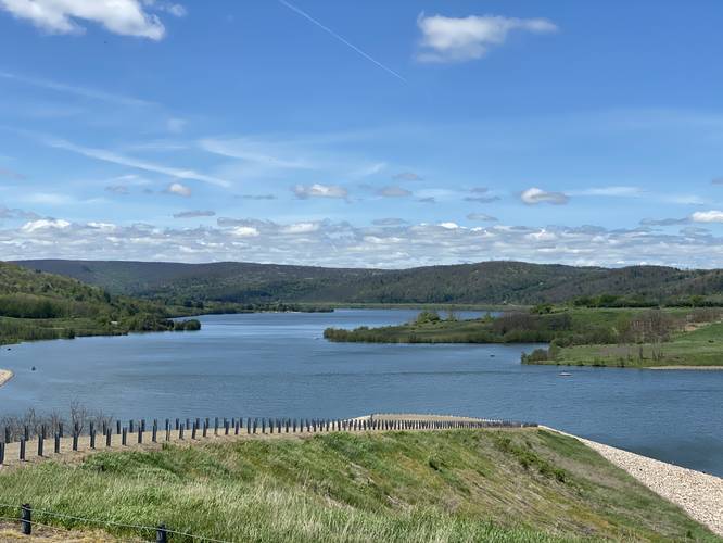
Hammond Lake Overlook
Parking
Visitors will find a large parking lot at the coordinates provided.
Accommodations
Restrooms can be found at the parking lot.
Pets
Dogs are allowed if leashed and their waste must be carried out by the hiker.
Know Before You Go
Interactive topographic map for Hammond Lake Overlook located in Tioga, PA. Click the "View Map" button to load GPS coordinates and trail markers.
View map
Get directions
- Distance
- 0.1 mi
- Difficulty
- Easy
- Type
- Out-and-Back
- Est. Time
- 5 min
- Elev. Gain
- 0'
- Rating
- 0.0
- Added
- June 02, 2020
- Updated
- June 02, 2020
Weather Forecast
Today
High
67°F
Chance Rain Showers then Chance Showers And Thunderstorms
Tonight
Low
60°F
Chance Showers And Thunderstorms
Thursday
High
72°F
Chance Rain Showers
Thursday Night
Low
58°F
Partly Cloudy
Friday
High
78°F
Mostly Sunny
Friday Night
Low
61°F
Mostly Cloudy
Saturday
High
79°F
Mostly Cloudy
Saturday Night
Low
64°F
Chance Rain Showers
Sunday
High
75°F
Showers And Thunderstorms Likely
Sunday Night
Low
63°F
Showers And Thunderstorms Likely
Monday
High
77°F
Chance Rain Showers then Chance Showers And Thunderstorms
Monday Night
Low
62°F
Chance Showers And Thunderstorms
Tuesday
High
80°F
Mostly Sunny then Chance Showers And Thunderstorms
Tuesday Night
Low
64°F
Chance Showers And Thunderstorms
Don't let Google decide who you trust.


Loading...
<strong>Trail map and elevation chart not rendering in print mode?</strong> Simply scroll to the trail map section, then try printing again!
Total Change
0 ft.
0 m
0 m
Ascent
0 ft.
0 m
0 m
Descent
0 ft.
0 m
0 m
Loading...
Features
- Vista / Lookout Point
- Dogs
-
 PA Wilds
Points of interest
-
Parking
41.897011, -77.141771 -
Main Trailhead
41.897097, -77.142218 -
Hammond Lake vista
41.897159, -77.142798
Safety information
For your own safety: plan ahead, let someone know where you'll be, and hike at your own risk.
Availability
All seasons
Surface type
Paved
Trip Reports (Reviews)
Ready to help fellow hikers? Add a trip report to share your experience!
No community routes found. To add your own hike as a Community Route for this Trail guide, leave a Trip Report with an attached GPX file.


You may also like

Explore
Pennsylvania's Grand Canyon
Explore Pennsylvania's Grand Canyon, officially named Pine Creek Gorge, including hiking trails, vistas, overlooks, waterfalls, backcountry campsites, backpacking trails.

Explore
New York's Best Waterfalls
Whether you're planning a day hike, roadside stop, or a leisurely short walk, this guide provides hikers, travelers, and locals alike with 63 different locations to over 100 scenic waterfalls to help plan your next adventure!

Explore
25 Best Day Hikes in West Virginia
Discover 25 of the best day hikes in West Virginia, from scenic overlooks to wilderness trails—perfect for every level of hiker.

Explore
Best of the Alps: Hiking, Adventure & Scenery
Plan your ultimate European Alps adventure! Discover the best hiking trails, epic scenery, and villages in the Swiss Alps, Dolomites, Chamonix, and Lake Como.
tioga-hammond lakes recreation area

