Loading...

WINTER SALE! 50% OFF Supporter Accounts — now through January 31st. Learn More.

Haipua'ena Falls

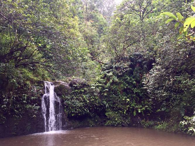
The Haipua'ena Falls Trail in Maui County, Hawaii is an easy 0.1 mile out-and-back hike to the 15 foot Haipua'ena Falls. The trail itself is often wet with larger rocks along the trail, so watch your step.

You'll pass through lush vegetation for no more than a few hundred feet before you reach the base of the falls. The pool in the falls can be used for swimming when the water is clear, but beware of flash flooding during heavier rains - do not attempt to swim or get close to the stream during heavy rains.

There's also a trail that leads up to the top of the falls, which is no more than 100 feet long one-way (not shown in GPS data).

Parking: Parking can be found on the western side of the stream/bridge.

Warning: Flash flooding is a common occurrence along streams in Hawaii. Please check the weather before hiking this trail and do not hike upstream if the water is brown and rushing. Flash floods can occur anytime upstream where heavy rains fall and you cannot always predict when a flash flood may happen. Be aware of the dangers and hike at your own risk.

Respecting the Land
Hawaiian land is considered sacred to native Hawaiians and many locals, so please stay on-trail, take nothing but photos, and leave nothing but footprints. Respect the locals - don't stay for long and have a backup hike planned in case the parking lot is full.
Explore 51 trails near Maui County, HI

Know Before You Go

  • Short, easy hike to Haipua'ena Falls (15 ft) with exotic vegetation.
  • Swimming is possible in the falls' pool when water is clear, but flash flooding is a risk.
  • Check weather conditions and avoid hiking if water is brown and rushing due to flash flood danger.
Interactive topographic map for Haipua'ena Falls located in Maui County, HI. Click the "View Map" button to load GPS coordinates and trail markers.
Get directions
Distance
0.1 mi
Difficulty
Easy
Type
Out-and-Back
Est. Time
5 min
Elev. Gain
38'
Rating
4.0
Added
August 29, 2018
Updated
August 12, 2025

Weather Forecast

Overnight
Low 69°F
Haze
Friday
High 79°F
Haze
Friday Night
Low 68°F
Chance Rain Showers
Saturday
High 77°F
Scattered Rain Showers
Saturday Night
Low 68°F
Scattered Rain Showers
Sunday
High 80°F
Haze
Sunday Night
Low 68°F
Haze
Monday
High 81°F
Sunny
Monday Night
Low 68°F
Scattered Rain Showers
Tuesday
High 77°F
Scattered Rain Showers
Tuesday Night
Low 66°F
Partly Cloudy
Wednesday
High 78°F
Mostly Sunny
Wednesday Night
Low 67°F
Partly Cloudy
Thursday
High 79°F
Mostly Sunny
Loading...
Total Change
38'
Ascent
38'
Descent
38'
Loading...

Download the GPX Data for Offline Use

Supporters get exclusive access to download trail routes to the MyHikes app for offline use. Stay prepared on your adventure, even without an internet connection! Become a Supporter today to unlock this feature and hike with confidence.

Download Haipua'ena Falls GPX Data to the MyHikes Mobile App

Features

Waterfalls
Water Source

Points of interest

  1. Parking

    20.866115, -156.176357
  2. Main Trailhead

    20.866355, -156.176002

Safety information

For your own safety: plan ahead, let someone know where you'll be, and hike at your own risk.

Availability

All seasons

Surface type

Dirt

Trip Reports (Reviews)

Rated 4.0 out of 5 based on 1 rating.

Ready to help fellow hikers? Add a trip report to share your experience and provide valuable insights for other hikers!

0.1 miles / 0.2 km
August 17, 2018
Hiking
No community routes found. To add your own hike as a Community Route for this Trail guide, leave a Trip Report with an attached GPX file.

Popular categories

Scenic mountain view representing vista trails
Vista trails
Scenic gorge of cascades representing waterfall trails
Waterfall hikes
Rugged mountain terrain representing summit trails
Summit trails
Scenic mountain view representing dog-friendly trails
Dog-friendly
Scenic campsite with a view representing camping trails
Camping trails
Appalachian Trail logo representing A.T. hikes
A.T. hikes

You May Also Like

Colorado's Million Dollar Highway - Plan a day's drive adventure along the iconic Million Dollar Highway in Colorado. Explore the best short trails, roadside stops, waterfalls, vistas, ghost towns, and hot springs within a ~6 hour road trip.
Explore

Colorado's Million Dollar Highway

Plan a day's drive adventure along the iconic Million Dollar Highway in Colorado. Explore the best short trails, roadside stops, waterfalls, vistas, ghost towns, and hot springs within a ~6 hour road trip.

Read
Glacier's Going-to-the-Sun Road - Discover the breathtaking beauty of Glacier National Park along the iconic Going-to-the-Sun Road. From stunning roadside stops to picturesque waterfalls and vistas, this engineering marvel offers endless opportunities for exploration.
Explore

Glacier's Going-to-the-Sun Road

Discover the breathtaking beauty of Glacier National Park along the iconic Going-to-the-Sun Road. From stunning roadside stops to picturesque waterfalls and vistas, this engineering marvel offers endless opportunities for exploration.

Read
🍪 We use cookies to learn about site usage and to serve map tiles. You may block cookies manually in the browser. By continuing you agree. Learn more