Loading...

WINTER SALE! 50% OFF Supporter Accounts — now through January 31st. Learn More.

H. H. Jackson Trail

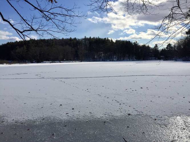
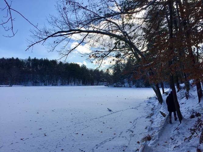
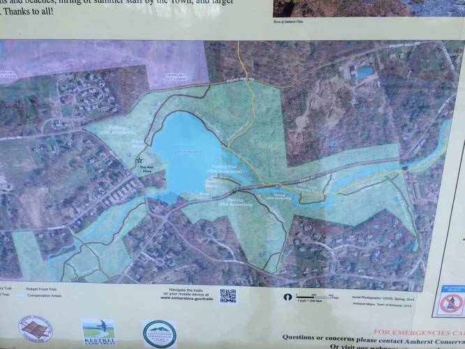
The H. H. Jackson Trail at Puffer's Pond Conservation Area in Amherst, Massachusetts is a short and easy 0.6 mile one-way hike around Puffer's Pond and up the hill to Pulpit Hill Road. This hike technically starts off along the Robert Frost Trail (orange blazes) and then quickly turns into the H. H. Jackson Trail (red blazes) just a couple hundred feet off the road. The trail winds along Puffer's Pond with a couple of different areas for fishing. The trail becomes fairly narrow with rocks and roots, so watch your step while hiking along the pond.

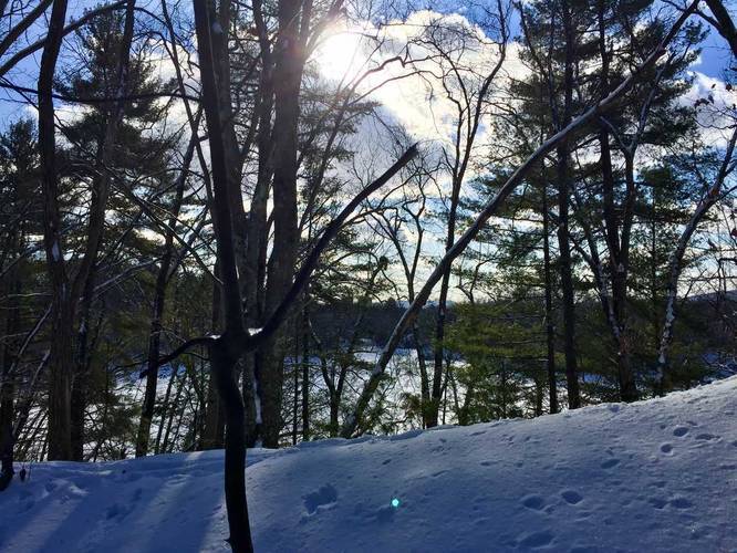
Once you reach the western side of the pond, you can turn right (just before the parking lot) to continue following the trail uphill towards Pulpit Hill Road. Just before you reach Pulpit Hill Road, there's a small spur trail that connects this one with the Robert Frost Trail again (heading back to parking) - in the winter, this trail gives you a little overlook of Puffer's Pond, UMass Amherst, and the Holyoke Range in the background. You cannot see this during months with leaves on the trees though.
Explore 209 trails near Amherst, MA

Know Before You Go

  • The H. H. Jackson Trail is a short, 0.6-mile one-way hike in Amherst, MA, beginning along the Robert Frost Trail before switching to red blazes.
  • The trail offers scenic views along Puffer's Pond, with fishing spots, but can be narrow and rocky.
  • A spur trail near Pulpit Hill Road provides winter views of Puffer's Pond, UMass Amherst, and the Holyoke Range, obscured by foliage in other seasons.
Interactive topographic map for H. H. Jackson Trail located in Amherst, MA. Click the "View Map" button to load GPS coordinates and trail markers.
Get directions
Distance
0.6 mi
Difficulty
Easy
Type
One-Way
Est. Time
18 min
Elev. Gain
87'
Rating
0.0
Added
December 31, 2017
Updated
June 12, 2018

Weather Forecast

Today
High 19°F
Heavy Snow
Tonight
Low 12°F
Heavy Snow
Monday
High 24°F
Light Snow
Monday Night
Low 5°F
Chance Light Snow then Partly Cloudy
Tuesday
High 20°F
Partly Sunny
Tuesday Night
Low -1°F
Partly Cloudy
Wednesday
High 22°F
Mostly Sunny
Wednesday Night
Low 0°F
Mostly Cloudy
Thursday
High 20°F
Partly Sunny
Thursday Night
Low -3°F
Partly Cloudy
Friday
High 19°F
Mostly Sunny
Friday Night
Low 0°F
Partly Cloudy
Saturday
High 25°F
Mostly Sunny
Saturday Night
Low 4°F
Partly Cloudy
Loading...
Total Change
86'
Ascent
87'
Descent
30'
Loading...

Download the GPX Data for Offline Use

Supporters get exclusive access to download trail routes to the MyHikes app for offline use. Stay prepared on your adventure, even without an internet connection! Become a Supporter today to unlock this feature and hike with confidence.

Download H. H. Jackson Trail GPX Data to the MyHikes Mobile App

Features

Dogs
Water Source
Biking

Points of interest

  1. Parking

    42.41608, -72.514869
  2. Main Trailhead

    42.416237, -72.515089
  3. View of Puffer's Pond

    42.418256, -72.518342
    View of Puffer's Pond
  4. View of Puffer's Pond

    42.418036, -72.518836
    View of Puffer's Pond

Safety information

For your own safety: plan ahead, let someone know where you'll be, and hike at your own risk.

Markers

Blaze Color

Red

Availability

All seasons

Surface type

Dirt

Trip Reports (Reviews)

Your opinion matters! Be the first to rate this trail.

Ready to help fellow hikers? Add a trip report to share your experience and provide valuable insights for other hikers!

0.6 miles / 1.0 km
December 28, 2017
Hiking
No community routes found. To add your own hike as a Community Route for this Trail guide, leave a Trip Report with an attached GPX file.

Popular categories

Scenic mountain view representing vista trails
Vista trails
Scenic gorge of cascades representing waterfall trails
Waterfall hikes
Rugged mountain terrain representing summit trails
Summit trails
Scenic mountain view representing dog-friendly trails
Dog-friendly
Scenic campsite with a view representing camping trails
Camping trails
Appalachian Trail logo representing A.T. hikes
A.T. hikes

You May Also Like

Colorado's Million Dollar Highway - Plan a day's drive adventure along the iconic Million Dollar Highway in Colorado. Explore the best short trails, roadside stops, waterfalls, vistas, ghost towns, and hot springs within a ~6 hour road trip.
Explore

Colorado's Million Dollar Highway

Plan a day's drive adventure along the iconic Million Dollar Highway in Colorado. Explore the best short trails, roadside stops, waterfalls, vistas, ghost towns, and hot springs within a ~6 hour road trip.

Read
Glacier's Going-to-the-Sun Road - Discover the breathtaking beauty of Glacier National Park along the iconic Going-to-the-Sun Road. From stunning roadside stops to picturesque waterfalls and vistas, this engineering marvel offers endless opportunities for exploration.
Explore

Glacier's Going-to-the-Sun Road

Discover the breathtaking beauty of Glacier National Park along the iconic Going-to-the-Sun Road. From stunning roadside stops to picturesque waterfalls and vistas, this engineering marvel offers endless opportunities for exploration.

Read
🍪 We use cookies to learn about site usage and to serve map tiles. You may block cookies manually in the browser. By continuing you agree. Learn more