Loading...

๐Ÿ‚ Prep for Fall! Unlock exclusive features to plan your perfect late-summer and autumn hikes โ€” become a Supporter today. Learn more.

Grooms Ridge and Chestnut Ridge Hike

Directions
Map
Pictures
Send to App
Distance:
9.0 Miles / 14.5 km
Type:
Loop
Difficulty:
Hard
Time to Hike:
4 hours, ~30 minutes
Features:
Surface Type:
Dirt
Park:
George Washington National Forest
Town:
Mount Solon, Virginia
Directions:
38.367014, -79.164465
Added:
January 25, 2025
Updated:
April 04, 2025
Guide by:
Copy Trail Link Hiking this trail? Send a friend or family member a link to this trail guide for your own safety. Hike at your own risk (disclaimer)
Loading...
Loading...
1,755'

Total Change
2,085'

Ascent
2,078'

Descent

Download the Trail Route for Offline Use

Supporters get exclusive access to download trail routes to the MyHikes app for offline use. Stay prepared on your adventure, even without an internet connection! Become a Supporter today to unlock this feature and hike with confidence.

Send to App

Key Takeaways

  • This 9-mile loop hike in Mount Solon, VA, offers a challenging workout with significant elevation gain and loss, primarily on the Chestnut Ridge ascent.
  • The hike features scenic viewpoints, especially from Cameron Rocks, and the area is known for its Mountain Laurel, which blooms in June.
  • Camping options are limited along the loop itself, but available at Todd Lake, North River campground, or dispersed sites along FR95.

Grooms Ridge and Chestnut Ridge Hike

The Grooms Ridge-Chestnut Ridge loop hike in the GWNF Todd's Lake Recreation Area is a great workout with almost 2800ft of elevation gain and an equal amount of loss. The initial 1.7 mile climb up Chestnut Ridge is relentless and will get your heart pumping, no switchbacks! Mountain Laurel is all over the place on this hike and will be beautiful when blooming in June. Some other great hikes in the Todd Lake area include: Trimble Mountain, Sandspring Mountain, North River Gorge, and Hardscrabble Knob.

There are a couple of nice year round viewing spots, and some more during the winter months when the leaves are down. There are not a lot of good campsites on this loop, but you could do some base camping at Todd Lake or the North River primitive campground that are close by. There are also many campsites next to North River along FR95. These are our favorite secluded spots to car camp when in the Todd Lake area.
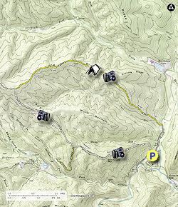
  • Mile 0.0 โ€“ The hike begins at the Wild Oak National Recreation Trail parking area, head back to FR95 and take a left back towards Tillman Road (gravel road) reaching it in 0.1 miles, bear left onto Tillman, reach Grooms Ridge Trail intersection on your left in 0.9 miles
  • Mile 1.0 โ€“ Grooms Ridge Trail (TR 424) on the left, wooden sign for trail is about 10 yards in from the road, on the opposite side of the road is room for 2 to 3 cars in the event you want to start your hike here. We wanted to get the gravel fire road walk out of the way first and not at the end of the hike.
  • Mile 2.6 โ€“ Climb 1250ft in 1.6 miles reaching a nice view point. This is a relentless climb with no switchbacks, catch your breath. Look for an unmarked path on the left to go down 100ft to Cameron Rocks for a nice view of Middle Mountain and over to Chestnut Ridge. This is a steep and small viewing area so be careful. Continue uphill on the Grooms Ridge Trail.
  • Mile 3.0 โ€“ In 0.4 miles arrive at a campsite on the left, no water source. The next section prior to reaching the pond is a little over-grown but not too bad.
  • Mile 4.9 โ€“ Small pond on the right.
  • Mile 5.2 โ€“ Intersection with Chestnut Ridge Trail , bear left. Grooms Ridge Trail goes straight and becomes part of the white-blazed 27 mile Wild Oak National Recreation Trail (WONRT). The Chestnut Ridge Trail is white-blazed as it is also part of the WONRT.
  • Mile 6.0 โ€“ Begin a steady descent on the Chestnut Ridge Trail reaching an obscured overlook in 0.8 miles. Little Bald Knob is to the northwest and Hardscrabble Knob (4282ft) almost directly to the west.
  • Mile 7.0 โ€“ V-intersection, Little Skidmore Trail (yellow blazed) goes straight. Take sharp left onto an unused fire road and then very quickly turn right, back onto the single track white-blazed Chestnut Ridge Trail.
  • Mile 7.7 โ€“ Top of Grindstone Mountain, this is the last climb of the day.
  • Mile 8.0 โ€“ Great view on the right looking down to Stokesville and east into the Shenandoah Valley.
  • Mile 8.8 โ€“ Parking area Spur Trail intersection, bear left, WONRT continues straight.
  • Mile 9.0 โ€“ Return to the parking area.
Explore 44 trails near Mount Solon, VA
  1. Parking

    38.367014, -79.164465
  2. Main Trailhead

    38.367132, -79.164391
No community routes found. To add your own hike as a Community Route for this Trail guide, leave a Trip Report with an attached GPX file.

Hazards

Ticks - Lyme Disease More Info (CDC)
Snakes
Poison Ivy/Oak

Seasons

All

Photo Albums

+ Add Photo Album

Upload your photos from the trail to help others know what to expect.

Trip Reports (Reviews)

Rated 3.8 out of 5 based on 5 ratings.
By: Patrick
9.0 miles / 14.5 km
February 09, 2019
We hiked this circuit hike this past Saturday. We had amazing winter ridge line views of the surrounding mountains and valleys. We did see all of the way into West Virginia, the Shenandoah Valley, and the very distant Blue Ridge Mountains. Please be aware that mountain bikers have made a new trail at the 7 mile mark, where the White Oak Trail leaves Chestnut Ridge. The new trail has white ribbon markings on the branches of the trees. This new trail does go straight down the hillside. THIS IS NOT THE WILD OAK TRAIL!! The Wild Oak Trail is as described in the hike description. It will be on your right hand side after you make the short descent from the road. Please be on the lookout for the trail on the right hand side after you leave the road. There are no white blazes, and you will need to be paying attention. I have notified the hiking group that does trail maintenance of this new trail that does not appear on any maps.
Legacy Review
By: Patrick
9.0 miles / 14.5 km
August 19, 2018
This hike is a very difficult and treacherous hike with a whole lot of bushwacking on the Grooms Ridge Trail from Cameron Rocks to the junction with the Wild Oak Trail. It was very difficult to find the trail at times during the hike. I only recall seeing two yellow blazes on the Grooms Ridge Trail from the Wild Oak junction to Cameron Rocks. I would only recommend this hike for those, who have good navigational skills and experienced hikers.
Legacy Review
By: Emilie
9.0 miles / 14.5 km
May 06, 2017
This is a good hike, but the directions leave out a key element: this hike is majority uphill. I'd hike it backwards -- we kept passing people going the opposite direction, which is probably a good idea. Plus you get the most beautiful views at the end. It was a nice hike, though. Some pretty vistas, and a pond on top of a ridge is just wild. But be forewarned: if you choose to go with these directions the hike is TOUGH. Lots and lots of climbing.
Legacy Review

Weather Forecast

In Mount Solon, VA

Explore Hiking Trails

You May Also Like

New York's Best Waterfalls - Whether you're planning a day hike, roadside stop, or a leisurely short walk, this guide provides hikers, travelers, and locals alike with 63 different locations to over 100 scenic waterfalls to help plan your next adventure!
Explore

New York's Best Waterfalls

Whether you're planning a day hike, roadside stop, or a leisurely short walk, this guide provides hikers, travelers, and locals alike with 63 different locations to over 100 scenic waterfalls to help plan your next adventure!

Read
25 Best Day Hikes in North Carolina - Discover the top 25 best day hikes in North Carolina, from breathtaking waterfalls to mountain peaks. Explore hidden gems, scenic views, and trails suitable for all skill levels, perfect for your next outdoor adventure.
Explore

25 Best Day Hikes in North Carolina

Discover the top 25 best day hikes in North Carolina, from breathtaking waterfalls to mountain peaks. Explore hidden gems, scenic views, and trails suitable for all skill levels, perfect for your next outdoor adventure.

Read

Before you boogie...

Find our trail guides useful? Consider becoming a Supporter to unlock perks!

MyHikes is an indie platform that makes exploring public trails easier for everyone. The platform has no investors, no ads, and is owned and operated by one person, Dave Miller. Dave has personally mapped and written over 1,800 trail guides on MyHikes for the public to explore. MyHikes has helped millions outdoor enthusiasts plan their next adventure.

But it takes a lot of time ๐Ÿ•ฆ, money ๐Ÿ’ฐ, work, and espresso shots โ˜• to run MyHikes, including hiking , mapping , writing , and publishing new trails with high-quality (accurate) information... along with software engineering (coding) the platform like building new features, website and mobile app development (iOS and Android), site maintainance . and much much more.

Supporters unlock website and mobile app perks with an annual one-time payment of $25 (you renew) ๐Ÿ˜Ž๐Ÿ‘. Or you can simply make a Donation of your choice. Otherwise, you can support us by telling your friends about MyHikes - both quick and free ๐ŸŽ‰

Admin user profile picture

Dave Miller
MyHikes Founder