The Grimsby Point Lookout Trail at Beamer Memorial Conservation Area in Grimsby, Ontario is an easy 1.6 km out-and-back hike that leads to beautiful views high above Grimsby and Lake Ontario from the cliffs of the Niagara Escarpment.
Hike
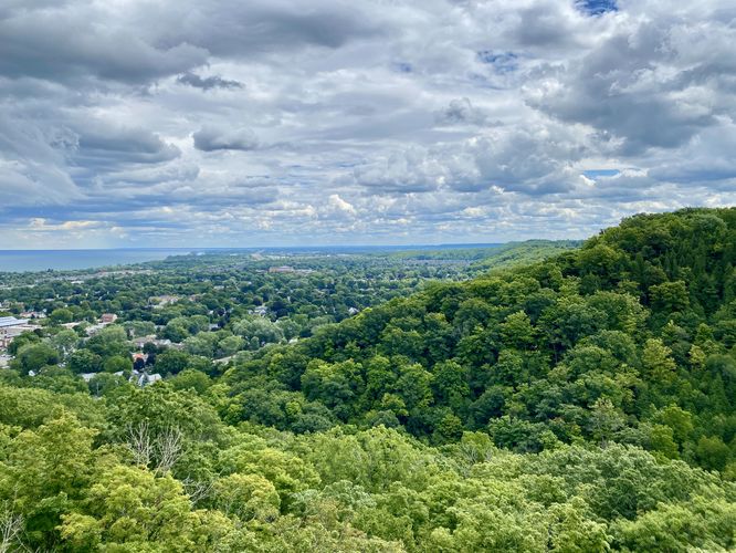
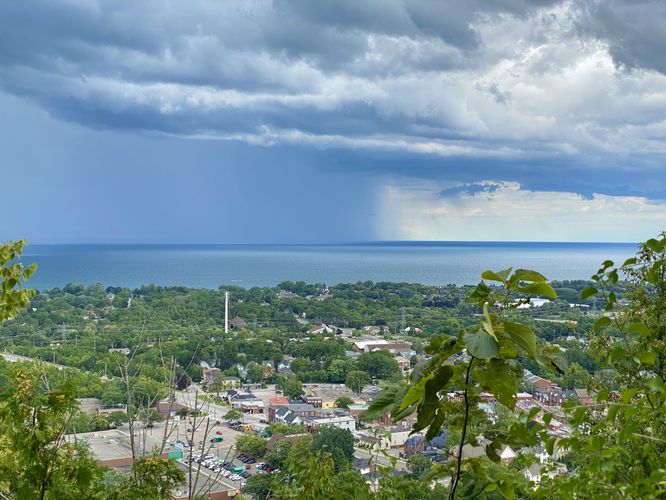
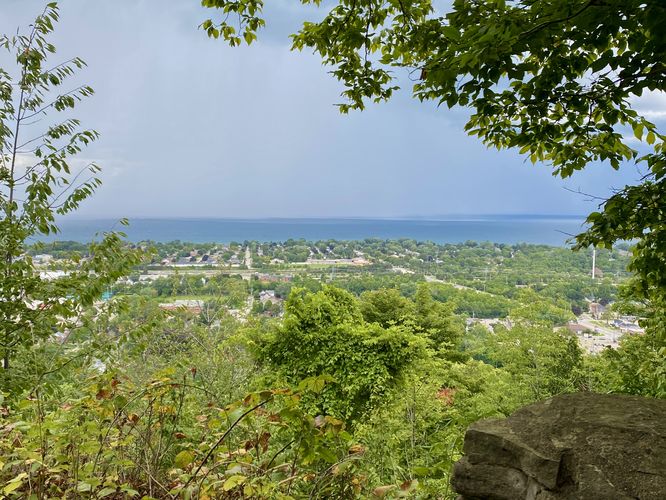
This short hike begins at the main parking lot for Beamer Memorial Conservation Area where hikers will walk down the main service road-like trail that leads further into the park. Around 0.15 km, hikers will reach an open field with a viewing tower that sits in the middle, which is likely used for bird watching as it's not tall enough to provide a view of much of anything. On the far side of this field is a sign labeled "Lookout Trail" which this route follows to reach Grimsby Point. From the sign keep-left as the trail leads through the forest along a mostly-flat path. Around 0.73 km, hikers will reach a loop where you can choose which views to visit first -- this route keeps-right at leads to the metal tower at the main cliff lookout at Grimsby Point. Hikers will find sweeping eastward views of the Niagara Escarpment from the lookout straight ahead with Lake Ontario and the town of Grimsby to the north (left). The trail continues on along the cliffs of the escarpment reaching a couple more viewpoints. The 2nd (middle) vista on the small loop provides views of Lake Ontario, Grimsby, and on clear days even Toronto in the distance. The 3rd vista on the loop provides a similar view as the middle vista, but as of August 2024, it was a bit more overgrown. After exploring the views at Grimsby Point, the trail leads back to parking for a short 1.6 km out-and-back hike.
Parking
Hikers will find a medium-sized parking lot at the coordinates provided, located on the east side of Quarry Road in Grimsby, ON. The lot is large enough to fit a dozen vehicles as of August 2024. During weekends, the lot fills up quickly and thus some people end up parking down the east side of Quarry Road.
Pets
Dogs are allowed only if leashed and must be cleaned up after.
Warning
Steep cliffs: The vistas at Grimsby Point sit along very steep cliffs with sheer drop-offs. Watch your step.
Hike
This short hike begins at the main parking lot for Beamer Memorial Conservation Area where hikers will walk down the main service road-like trail that leads further into the park. Around 0.15 km, hikers will reach an open field with a viewing tower that sits in the middle, which is likely used for bird watching as it's not tall enough to provide a view of much of anything. On the far side of this field is a sign labeled "Lookout Trail" which this route follows to reach Grimsby Point. From the sign keep-left as the trail leads through the forest along a mostly-flat path. Around 0.73 km, hikers will reach a loop where you can choose which views to visit first -- this route keeps-right at leads to the metal tower at the main cliff lookout at Grimsby Point. Hikers will find sweeping eastward views of the Niagara Escarpment from the lookout straight ahead with Lake Ontario and the town of Grimsby to the north (left). The trail continues on along the cliffs of the escarpment reaching a couple more viewpoints. The 2nd (middle) vista on the small loop provides views of Lake Ontario, Grimsby, and on clear days even Toronto in the distance. The 3rd vista on the loop provides a similar view as the middle vista, but as of August 2024, it was a bit more overgrown. After exploring the views at Grimsby Point, the trail leads back to parking for a short 1.6 km out-and-back hike.
Parking
Hikers will find a medium-sized parking lot at the coordinates provided, located on the east side of Quarry Road in Grimsby, ON. The lot is large enough to fit a dozen vehicles as of August 2024. During weekends, the lot fills up quickly and thus some people end up parking down the east side of Quarry Road.
Pets
Dogs are allowed only if leashed and must be cleaned up after.
Warning
Steep cliffs: The vistas at Grimsby Point sit along very steep cliffs with sheer drop-offs. Watch your step.