Great Falls Trail in Canaan, Connecticut is an easy 0.5-mile out-and-back hike that features views of the massive 50-foot waterfall, Great Falls of the Housatonic.
Hike Description
This hike begins at the main trailhead located at the public parking for Great Falls along the eastern side of Housatonic River Road. The trailhead is located on the southern end of the parking lot and heads into the woods as it traverses rock-covered leaves and bedrock to reach view points of Great Falls.
Great Falls Viewpoint - Mile 0.05
Within just a few-hundred feet, hikers will find an off-shoot trail that leads to the cliffs adjacent to Great Falls -- here, you can get an unobstructed view from the side of Great Falls. Just watch your step as one false move might mean that you won't be returning home from Great Falls -- as directly below are the raging waters of the cascade.
Great Falls Viewpoint #2 - Mile 0.15
The trail then continues onward to reach a 4-way junction -- take a left-hand turn around mile 0.1 to head out to the dead-end path that leads to a proper fenced-in viewpoint of Great Falls, located around mile 0.15. At this viewpoint, hikers will get more views from the side of Great Falls. This is an amazing spot to hike to and turn-around if you wish, but there's one more viewpoint you might want to checkout before you leave, a view of the entire waterfall from downstream.
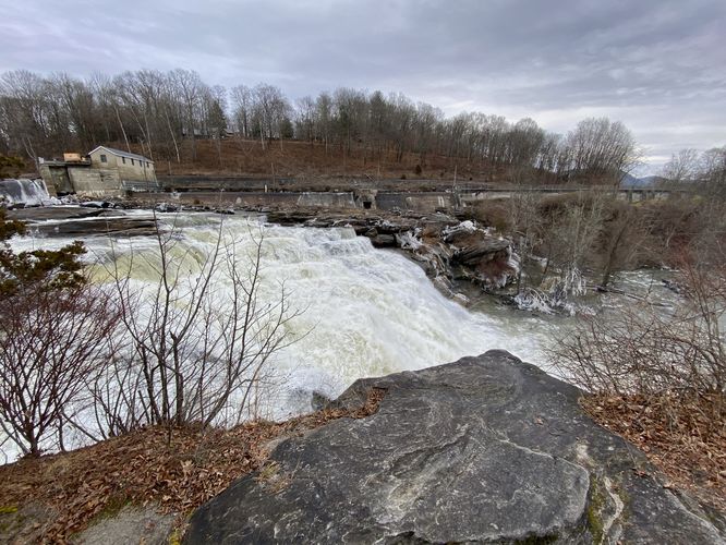
Great Falls Base Viewpoint - Mile 0.3
Hikers will hop back onto the trail and keep left at the previous 4-way junction to hike downhill slightly. The trail will curve around the hillside to eventually reach a "clearing" on the hill. From here, hikers will get a view of Great Falls from downstream -- a view of the entire 50-foot tall and several-hundred-foot long waterfall. There's also another path that leads downhill to reach the banks of the Housatonic River located just down the trail around mile 0.33, but it looked pretty sketchy on our hike in late December 2023, so we skipped that view.
After exploring the three viewpoints of Great Falls (Great Falls of the Housatonic), hikers will head out the same way they hiked-in on for a 0.5-mile out-and-back hike.
Parking
Hikers will find a large parking lot at the coordinates provided, located on the east side of Housatonic River Road in Canaan (Falls Village), CT. The lot is large enough to fit a dozen vehicles or so.
Pets
Dogs are allowed if leashed and must be cleaned up after.
Warning
Steep cliffs: This hike leads along some steep and dangerous cliffs. Watch your step and be careful if planning to hike to the cliff's edge where there's no fencing.
Hike Description
This hike begins at the main trailhead located at the public parking for Great Falls along the eastern side of Housatonic River Road. The trailhead is located on the southern end of the parking lot and heads into the woods as it traverses rock-covered leaves and bedrock to reach view points of Great Falls.
Great Falls Viewpoint - Mile 0.05
Within just a few-hundred feet, hikers will find an off-shoot trail that leads to the cliffs adjacent to Great Falls -- here, you can get an unobstructed view from the side of Great Falls. Just watch your step as one false move might mean that you won't be returning home from Great Falls -- as directly below are the raging waters of the cascade.
Great Falls Viewpoint #2 - Mile 0.15
The trail then continues onward to reach a 4-way junction -- take a left-hand turn around mile 0.1 to head out to the dead-end path that leads to a proper fenced-in viewpoint of Great Falls, located around mile 0.15. At this viewpoint, hikers will get more views from the side of Great Falls. This is an amazing spot to hike to and turn-around if you wish, but there's one more viewpoint you might want to checkout before you leave, a view of the entire waterfall from downstream.
Great Falls Base Viewpoint - Mile 0.3
Hikers will hop back onto the trail and keep left at the previous 4-way junction to hike downhill slightly. The trail will curve around the hillside to eventually reach a "clearing" on the hill. From here, hikers will get a view of Great Falls from downstream -- a view of the entire 50-foot tall and several-hundred-foot long waterfall. There's also another path that leads downhill to reach the banks of the Housatonic River located just down the trail around mile 0.33, but it looked pretty sketchy on our hike in late December 2023, so we skipped that view.
After exploring the three viewpoints of Great Falls (Great Falls of the Housatonic), hikers will head out the same way they hiked-in on for a 0.5-mile out-and-back hike.
Parking
Hikers will find a large parking lot at the coordinates provided, located on the east side of Housatonic River Road in Canaan (Falls Village), CT. The lot is large enough to fit a dozen vehicles or so.
Pets
Dogs are allowed if leashed and must be cleaned up after.
Warning
Steep cliffs: This hike leads along some steep and dangerous cliffs. Watch your step and be careful if planning to hike to the cliff's edge where there's no fencing.