Loading...

❄️ WINTER SALE! 50% OFF on Supporter Accounts — now through January 31st. Unlock a full year of exclusive website & app perks. Learn More.

Great Channels Hike

The Great Channels features a maze of slot canyons similar to what you may find in the southwestern United States. The hike is a hidden gem in southwest Virginia and you will find nothing else in Virginia quite like it. The Great Channels Natural Area Preserve is one of Virginia’s most geologically fascinating areas. This 6.6 mile out-and-back takes you down into a network of maze-like crevices formed in soft sandstone.

      For a more detailed description go to Virginia Trail Guide's site.

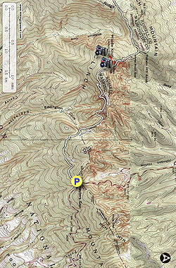
  • Mile 0.0 – From the right side of the parking area, head past the entrance gate and continue uphill on the white-blazed Brumley Mountain Trail.
  • Mile 0.6 – Reach an opening created by power lines for an obstructed view.
  • Mile .75 – Reach a junction where the fire road turns to the right uphill, but stay straight on the Brumley Mountain Trail which now becomes a dirt path.
  • Mile 1.0 – On the right you will see some privately-owned cabins, but there is no trespassing on this private property.
  • Mile 1.5 – You reach Shallow Gap, which provides some obstructed views to the right of the trail through the trees. The trail begins to become steeper.
  • Mile 2.25 – Come to a small outcrop of sandstone, similar to what you will find at the Great Channels. Shortly after this, you will begin a couple of switchbacks, which take away some of the steepness of the terrain
  • Mile 2.8 – Reach a junction with the Great Channels Trail. Take a left on this red-blazed trail to the summit. Go through a tunnel of rhododendren on your approach.
  • Mile 3.0 – Reach the summit of Middle Knob. Here you will find a rundown, abandoned shelter and see the fire tower about 50 yards ahead. Walk to the right of the fire tower and you will see a sign near the entrance of the woods noting the Great Channels is ahead. The trail is steep and down a slick grade, so be careful with your footing.
  • Mile 3.2 – Reach the entrance to the Great Channels. Explore the interesting rock formations before heading back the way you came.
  • Mile 3.5 – Return to the summit of Middle Knob and the fire tower.
  • Mile 3.7 – Reach the junction with the white-blazed Brumley Mountain Trail. Take a right to follow the trail back to your starting point.
  • Mile 4.75 – Reach the junction where the fire road takes a sharp left uphill. Stay straight.
  • Mile 5.9 – Pass through the gate and return to the parking area and the end of the hike.
By HikingUpward Contributors: Christine and Adam Anderson
Explore 14 trails near Saltville, VA

Know Before You Go

  • The Great Channels hike in Saltville, VA offers a unique experience with slot canyons reminiscent of the southwestern US.
  • The 5.9-mile hike follows the Brumley Mountain Trail (white blazes) to a junction with the Great Channels Trail (red blazes), leading to Middle Knob summit and the entrance to the Great Channels.
  • The trail includes varied terrain such as dirt paths, switchbacks, and a steep descent to the Channels, requiring careful footing, with notable points including power lines, Shallow Gap, sandstone outcrops, and a fire tower.
Interactive topographic map for Great Channels Hike located in Saltville, VA. Click the "View Map" button to load GPS coordinates and trail markers.
Get directions
Distance
5.9 mi
Difficulty
Moderate
Type
Out-and-Back
Est. Time
3 hrs
Elev. Gain
1,290'
Rating
4.5
Added
February 28, 2025
Updated
April 05, 2025

Weather Forecast

Loading...
Total Change
1,188'
Ascent
1,290'
Descent
1,290'
Loading...

Download the GPX Data for Offline Use

Supporters get exclusive access to download trail routes to the MyHikes app for offline use. Stay prepared on your adventure, even without an internet connection! Become a Supporter today to unlock this feature and hike with confidence.

Download Great Channels Hike GPX Data to the MyHikes Mobile App

Features

Vista / Lookout Point
Dogs
Mountain Summit
Camping

Points of interest

  1. Parking

    36.864451, -81.946904
  2. Main Trailhead

    36.864451, -81.946904

Safety information

For your own safety: plan ahead, let someone know where you'll be, and hike at your own risk.

Hazards

Snakes (Rattlesnakes, Copperheads, others)
Poison Ivy or Poison Oak

Markers

Blaze Color

White

Availability

All seasons

Surface type

Dirt

Trip Reports (Reviews)

Rated 4.5 out of 5 based on 2 ratings.

Ready to help fellow hikers? Add a trip report to share your experience and provide valuable insights for other hikers!

By: Medic-G
5.9 miles / 9.5 km
July 10, 2022
Since there hasn't been a trail review in several years, I thought I would write one. My wife and I did this hike on July 10th. We saw this hike on Hiking Upward and put it on our list of hikes to do. Since this hike was so far from where we lived, we decided to make a 3 day adventure out of it. We decided to stay and camp at Hungry Mother State Park which is about 32 miles from the parking area. The directions I printed off from Google Maps stated you had to turn off of Route 80 on to another road to get to the parking area. This was a little confusing/misleading because the parking area is on Route 80 right near the Washington and Russell County line. As the description states, you start by going up the gravel drive/road to the right side of the parking area. This is a drive/road which leads to Raven Ridge Lodge. This would be another option for a place to stay if you are traveling a distance to do this hike. A Google search for Raven Ridge Lodge at Hayters Gap should net you needed information if you are looking to stay there. There is a sign for the lodge posted to a tree at the end of the gravel drive/road beside the parking area. This is where you begin your hike and can also help you spot the parking area traveling up Route 80. There is also a wood kiosk/information board at the parking area however, there wasn't much information posted there.
Legacy Review
By: Smell N Roses
5.9 miles / 9.5 km
September 05, 2020
Hiking Upwards needs to stop posting trip reports to my favorite secret spots! This is an awesome hike! The trip report failed to mention that if you keep a sharp eye open, there are multiple spots where you can climb on top of the rocks for awesome views of the surrounding area. You can easily see Beartown Mountain (VA's 7th highest) and the Mount Rogers high country, as well as the spine of Clinch and Brumley Mountains, Big A Mountain, and more. The trail is part of the Brumley Mountain Trail which connects with Hidden Valley WMA (fee area). So much to do in the nearby area as well. This part of Virginia is not well known to outsiders.
Legacy Review
No community routes found. To add your own hike as a Community Route for this Trail guide, leave a Trip Report with an attached GPX file.

Popular categories

Scenic mountain view representing vista trails
Vista trails
Scenic gorge of cascades representing waterfall trails
Waterfall hikes
Rugged mountain terrain representing summit trails
Summit trails
Scenic mountain view representing dog-friendly trails
Dog-friendly
Scenic campsite with a view representing camping trails
Camping trails
Appalachian Trail logo representing A.T. hikes
A.T. hikes

You May Also Like

25 Best Day Hikes in North Carolina - Discover the top 25 best day hikes in North Carolina, from breathtaking waterfalls to mountain peaks. Explore hidden gems, scenic views, and trails suitable for all skill levels, perfect for your next outdoor adventure.
Explore

25 Best Day Hikes in North Carolina

Discover the top 25 best day hikes in North Carolina, from breathtaking waterfalls to mountain peaks. Explore hidden gems, scenic views, and trails suitable for all skill levels, perfect for your next outdoor adventure.

Read
🍪 We use cookies to learn about site usage and to serve map tiles. You may block cookies manually in the browser. By continuing you agree. Learn more