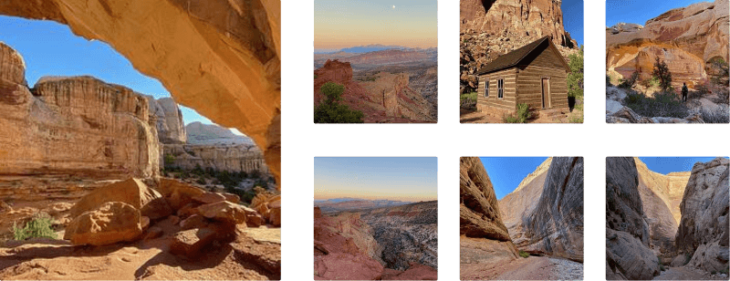
Grand Wash to The Narrows at Capitol Reef National Park near Fruita, Utah is an easy 2.4-mile out-and-back hike that leads to The Narrows - steep and narrow canyon cliffs that soar hundreds of feet into the air. The hike also includes rock carvings, optional scrambles, and interesting tunnels and rock formations that were carved out by water over millennia.
Trails
This hike follows one named trail: Grand Wash Trail.
Hike Description
This hike begins along UT-24 at the main trailhead for the Grand Wash. Hikers will head into the dry creek bed (dry wash) to begin their hike, but as of September 2023, the start is a bit confusing. Hikers will walk down the very steep, but short, embankment just beyond the trailhead sign. This embankment is full of human-placed rocks that are built-up to keep the trail from washing away during flash floods, but it's also held back with a metal grate material that's a bit broken. Watch your step and don't let the rusty metal cut you on the hike in.
Once in Grand Wash, the hike is easy and straight forward - follow the dry creek bed upstream to reach The Narrows (or further if you wish), however, there are some points-of-interest along the way that you might want to check out on your way.
Steep Canyon Cliffs - Mile 0.3
Around mile 0.3, the steep canyon cliffs of Grand Wash start to really come into view. If hiking with a partner, this starts photo opportunities where you can snap a shot with your friend, spouse, or partner for scale - as it's virtually impossible to tell how tall these massive cliff walls really are without some frame of reference.
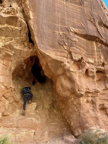
Optional Scramble - Mile 0.43
Around mile 0.43, hikers may spot a neat-looking rock scramble that leads into a dead-end cave, located on the south side of the trail. This ~10-foot rock scramble is pretty fun stop along the Grand Wash to try out your hand at some very-light rock climbing.
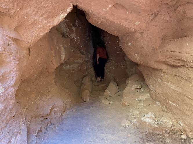
Optional Tunnel Exploration - mile 0.55
Around mile 0.55, located on the north side of the trail, is a deep tunnel that juts approximately 30-feet into the canyon's cliff side. If you're looking for another strange stop along the Grand Wash, be on the lookout for this funky dead-end tunnel.
Towering Cliffs - Mile 0.6
At mile 0.6, after the 5th large bend in the trail, Grand Wash's cliff walls will become even more steep and grand, with plenty of water markings that permeate through and stain the rock walls.
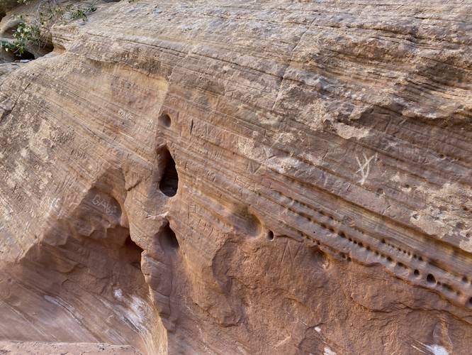
Rock Carvings - Mile 0.7
At mile 0.7, located on the eastern cliff wall, are a ton of rock carvings that hikers and visitors have left-behind over the years. Please do not add your own! Take photos or try to find the oldest carving you can for some additional fun in the Grand Wash.
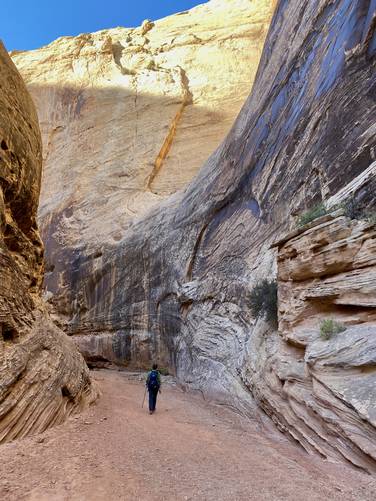
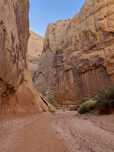
The Narrows - Mile 1
Around mile 1, hikers will reach The Narrows. The beginning of The Narrows is defined by the very-close and tight space between the massive cliff walls of Grand Wash. These cliffs go from being a several-hundred feet apart to less than 100-feet in some places. With towering cliff walls, The Narrows is a sight-to-see, but only during clear weather. This GPS track leads hikers down into The Narrows of Grand Wash for just a short while, approximately 0.2-miles before turning back at the 2nd tight curve in Grand Wash. Within The Narrows are more funky rock formations like holes carved out by water over millennia.
Hiking Out - Mile 1.2 to 2.4
Again, this guide and GPS data ends just 0.2-miles into The Narrows of Grand Wash; however, it brings hikers to one of the most spectacular parts of Grand Wash before heading out. The hike out is obviously just as easy as the hike in. If you started the hike in the morning, however, the sun will beat down on you for the last ~0.5-miles of hiking as you make your way out of Grand Wash's wide canyon.
Parking
Hikers will find a medium-sized parking turnout at the coordinates provided. There's extra parking along the road and on the north side of Grand Wash if the southern lots are full.
Pets
Dogs are not allowed on this trail.
Warnings
Flash flooding: This trail follows a dry wash (dry creek bed) and thus flash flooding is a common occurrence from July through September. Flash flooding happens after heavy rainfall but just a 1/2 inch of rainfall can cause flash floods here. Always pay attention to local weather before heading out, especially upstream from where you plan on hiking, to avoid any/all flash flooding. Check with the local ranger station or park station to understand more about current flash flood conditions before venturing into this type of terrain.
Sun exposure: This trail has very little shade during mid-day as the sun beats down directly on the trail. Bring plenty of water (1-gallon per person per day) and sun protection if planning to hike during mid-day sun, otherwise it's smart to plan to hike in the early morning or evening. If hiking this trail during the morning or evening, you'll receive plenty of shade from the massive canyon walls with some exceptions.
Rattlesnakes: Rattlesnakes call this area home and could be found out on the trail during warm/hot months. If found, please give these snakes plenty of space.
Rockfalls: This trail passes under very large cliffs that sometimes have rockfall activity. There's no warning and nothing anyone can do about rockfalls, but just be mindful.
Trails
This hike follows one named trail: Grand Wash Trail.
Hike Description
This hike begins along UT-24 at the main trailhead for the Grand Wash. Hikers will head into the dry creek bed (dry wash) to begin their hike, but as of September 2023, the start is a bit confusing. Hikers will walk down the very steep, but short, embankment just beyond the trailhead sign. This embankment is full of human-placed rocks that are built-up to keep the trail from washing away during flash floods, but it's also held back with a metal grate material that's a bit broken. Watch your step and don't let the rusty metal cut you on the hike in.
Once in Grand Wash, the hike is easy and straight forward - follow the dry creek bed upstream to reach The Narrows (or further if you wish), however, there are some points-of-interest along the way that you might want to check out on your way.
Steep Canyon Cliffs - Mile 0.3
Around mile 0.3, the steep canyon cliffs of Grand Wash start to really come into view. If hiking with a partner, this starts photo opportunities where you can snap a shot with your friend, spouse, or partner for scale - as it's virtually impossible to tell how tall these massive cliff walls really are without some frame of reference.
Optional Scramble - Mile 0.43
Around mile 0.43, hikers may spot a neat-looking rock scramble that leads into a dead-end cave, located on the south side of the trail. This ~10-foot rock scramble is pretty fun stop along the Grand Wash to try out your hand at some very-light rock climbing.
Optional Tunnel Exploration - mile 0.55
Around mile 0.55, located on the north side of the trail, is a deep tunnel that juts approximately 30-feet into the canyon's cliff side. If you're looking for another strange stop along the Grand Wash, be on the lookout for this funky dead-end tunnel.
Towering Cliffs - Mile 0.6
At mile 0.6, after the 5th large bend in the trail, Grand Wash's cliff walls will become even more steep and grand, with plenty of water markings that permeate through and stain the rock walls.
Rock Carvings - Mile 0.7
At mile 0.7, located on the eastern cliff wall, are a ton of rock carvings that hikers and visitors have left-behind over the years. Please do not add your own! Take photos or try to find the oldest carving you can for some additional fun in the Grand Wash.
The Narrows - Mile 1
Around mile 1, hikers will reach The Narrows. The beginning of The Narrows is defined by the very-close and tight space between the massive cliff walls of Grand Wash. These cliffs go from being a several-hundred feet apart to less than 100-feet in some places. With towering cliff walls, The Narrows is a sight-to-see, but only during clear weather. This GPS track leads hikers down into The Narrows of Grand Wash for just a short while, approximately 0.2-miles before turning back at the 2nd tight curve in Grand Wash. Within The Narrows are more funky rock formations like holes carved out by water over millennia.
Hiking Out - Mile 1.2 to 2.4
Again, this guide and GPS data ends just 0.2-miles into The Narrows of Grand Wash; however, it brings hikers to one of the most spectacular parts of Grand Wash before heading out. The hike out is obviously just as easy as the hike in. If you started the hike in the morning, however, the sun will beat down on you for the last ~0.5-miles of hiking as you make your way out of Grand Wash's wide canyon.
Parking
Hikers will find a medium-sized parking turnout at the coordinates provided. There's extra parking along the road and on the north side of Grand Wash if the southern lots are full.
Pets
Dogs are not allowed on this trail.
Warnings
Flash flooding: This trail follows a dry wash (dry creek bed) and thus flash flooding is a common occurrence from July through September. Flash flooding happens after heavy rainfall but just a 1/2 inch of rainfall can cause flash floods here. Always pay attention to local weather before heading out, especially upstream from where you plan on hiking, to avoid any/all flash flooding. Check with the local ranger station or park station to understand more about current flash flood conditions before venturing into this type of terrain.
Sun exposure: This trail has very little shade during mid-day as the sun beats down directly on the trail. Bring plenty of water (1-gallon per person per day) and sun protection if planning to hike during mid-day sun, otherwise it's smart to plan to hike in the early morning or evening. If hiking this trail during the morning or evening, you'll receive plenty of shade from the massive canyon walls with some exceptions.
Rattlesnakes: Rattlesnakes call this area home and could be found out on the trail during warm/hot months. If found, please give these snakes plenty of space.
Rockfalls: This trail passes under very large cliffs that sometimes have rockfall activity. There's no warning and nothing anyone can do about rockfalls, but just be mindful.