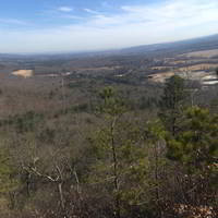
The Grace A. Robson Sanctuary Trail is located on Reservoir Rd in Westfield, Massachusetts and is a difficult 4.1-mile loop hike that features a beautiful vista atop Tekoa Mountain.
The trailhead is located roughly a half-mile from the gate on Reservoir Rd; however, this recording includes the out-and-back trail that leads from the parking area to the main loop and the main trailhead. There is a bridge leading over Moose Meadow Brook to where the official trailhead is located. By the trailhead there is a small reservoir with a dam that is under construction as of October 2019. Hikers should note that trail markings, signs, and blazes are few and far between so having a physical trail map, offline maps, or cell service to check MyHikes can be useful here.
Tekoa Mountain - Easy Ascent
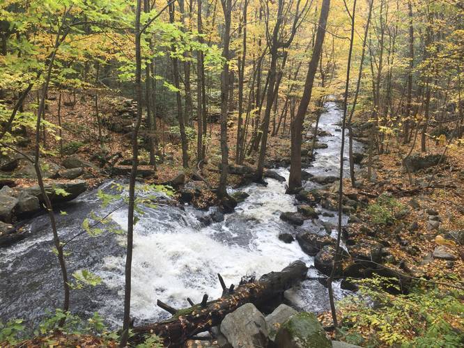
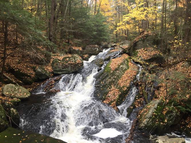
The longer, but less steep ascent, is located by taking a right-hand turn at the main loop and heads north along an access road that follows Moose Meadow Brook. This access road lasts for roughly 0.4-miles and at this point the access road continues on, but there will be a left-hand turn just before an old bridge - follow trail to the left here. This is one section that is marked with a mix of yellow and red/pink blazes. The trail keeps to the side of the brook as it starts to head up Tekoa Mountain. It also shifts from a wide access road to a small path as it cuts through the hillside. After about a half mile, there will be a waterfall on your right - there does not seem to be any access from this side of the brook, but is easily accessible by bushwhacking. After the waterfall, the trail continues on northward and heads further up the mountain for roughly 0.4-miles before reaching what looks like another access road. It should be noted that in this section, there is a marked trail (white blazes) that turns right down toward the brook again. After looking a several maps, I was unable to get any information on this trail. When ascending Tekoa Mountain from this route, the trail can be easily missed, but if you choose to come back this direction, it can be very confusing. Once on the new access road, turn left and start heading south up the mountain. The summit and lookouts are roughly 0.6 miles ahead. After visiting the lookout points, the trail continues to head southeast and then finally north, making a complete loop back to the trailhead. Hiking back to parking from here is as simple as following the Reservoir Rd trail to the gate.
Tekoa Mountain - Difficult Ascent
For those looking for a shorter hike and a challenge, the ascent from the south is what you're looking for. Beyond the bridge by the reservoir and trailhead, turn left and head south. There are no blazes during this short section and when the leaves have fallen, it may be hard to discern where the trail leads off. It seems there are 2 options: both are only about 0.25 miles long. There are 2 main turns, both on the right hand side of the trail leading towards the ridge you will take to the summit. If you head straight down the trail along the rock walls, it appears that it will eventually turn west and then heads north and up the mountain. There are also some breaks in the wall that indicate another path. While some look like game trails (deer trails), there is one that is clearly a foot path, but this recording did not pick it up right away. Once you reach the main trail to the summit it will be very clear, the elevation changes are noticeable right away and a clear path leads up to the summit.
Warnings
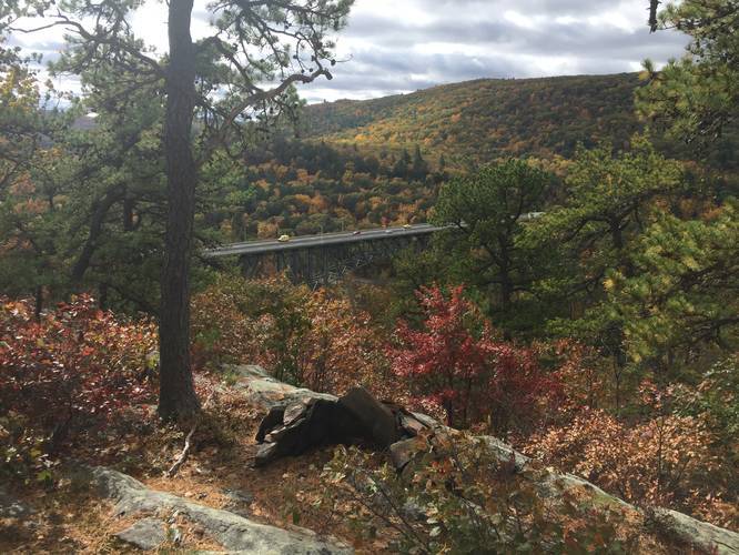
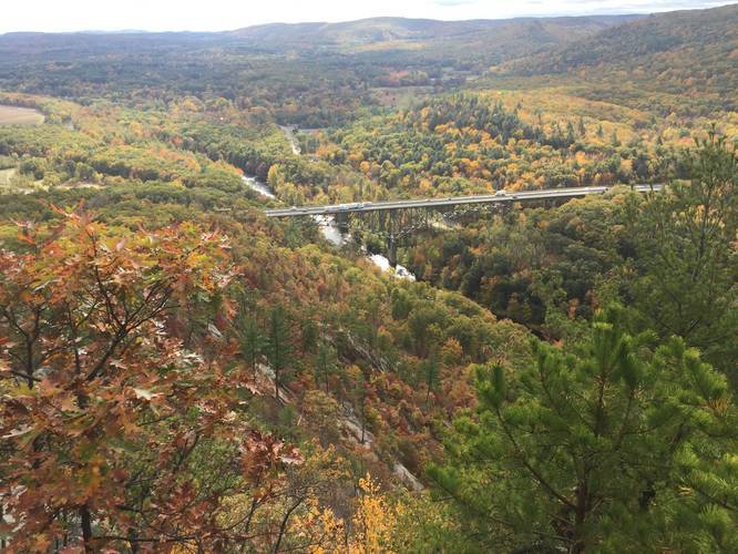
The trail to the summit, while easy to follow, should not be considered easy. It is both rocky, steep, and somewhat overgrown/narrow in many places. This mountain, much like Mt. Tom is also a native habitat for Timber Rattlesnakes that are rarely seen. There is also a short but challenging section where you must scramble a short distance up a rock face that is a drop-off on one side. There are many overlooks, ledges and cliff walks along this route and some side trails as well. This section should not be recommended to new hikers or children.
Parking
Hikers can find parking at the coordinates provided along Reservoir Rd in Westfield. Parking is located by the access gate - please do not block the gate so that state officials can enter when necessary.
Pets
Dogs are allowed if leashed and their waste must be carried out by the hiker.
Biking
Mountain biking is permitted along some of the trails here; however, it's not recommended to bike along Tekoa Mountain. Yield to hikers.
The trailhead is located roughly a half-mile from the gate on Reservoir Rd; however, this recording includes the out-and-back trail that leads from the parking area to the main loop and the main trailhead. There is a bridge leading over Moose Meadow Brook to where the official trailhead is located. By the trailhead there is a small reservoir with a dam that is under construction as of October 2019. Hikers should note that trail markings, signs, and blazes are few and far between so having a physical trail map, offline maps, or cell service to check MyHikes can be useful here.
Tekoa Mountain - Easy Ascent
The longer, but less steep ascent, is located by taking a right-hand turn at the main loop and heads north along an access road that follows Moose Meadow Brook. This access road lasts for roughly 0.4-miles and at this point the access road continues on, but there will be a left-hand turn just before an old bridge - follow trail to the left here. This is one section that is marked with a mix of yellow and red/pink blazes. The trail keeps to the side of the brook as it starts to head up Tekoa Mountain. It also shifts from a wide access road to a small path as it cuts through the hillside. After about a half mile, there will be a waterfall on your right - there does not seem to be any access from this side of the brook, but is easily accessible by bushwhacking. After the waterfall, the trail continues on northward and heads further up the mountain for roughly 0.4-miles before reaching what looks like another access road. It should be noted that in this section, there is a marked trail (white blazes) that turns right down toward the brook again. After looking a several maps, I was unable to get any information on this trail. When ascending Tekoa Mountain from this route, the trail can be easily missed, but if you choose to come back this direction, it can be very confusing. Once on the new access road, turn left and start heading south up the mountain. The summit and lookouts are roughly 0.6 miles ahead. After visiting the lookout points, the trail continues to head southeast and then finally north, making a complete loop back to the trailhead. Hiking back to parking from here is as simple as following the Reservoir Rd trail to the gate.
Tekoa Mountain - Difficult Ascent
For those looking for a shorter hike and a challenge, the ascent from the south is what you're looking for. Beyond the bridge by the reservoir and trailhead, turn left and head south. There are no blazes during this short section and when the leaves have fallen, it may be hard to discern where the trail leads off. It seems there are 2 options: both are only about 0.25 miles long. There are 2 main turns, both on the right hand side of the trail leading towards the ridge you will take to the summit. If you head straight down the trail along the rock walls, it appears that it will eventually turn west and then heads north and up the mountain. There are also some breaks in the wall that indicate another path. While some look like game trails (deer trails), there is one that is clearly a foot path, but this recording did not pick it up right away. Once you reach the main trail to the summit it will be very clear, the elevation changes are noticeable right away and a clear path leads up to the summit.
Warnings
The trail to the summit, while easy to follow, should not be considered easy. It is both rocky, steep, and somewhat overgrown/narrow in many places. This mountain, much like Mt. Tom is also a native habitat for Timber Rattlesnakes that are rarely seen. There is also a short but challenging section where you must scramble a short distance up a rock face that is a drop-off on one side. There are many overlooks, ledges and cliff walks along this route and some side trails as well. This section should not be recommended to new hikers or children.
Parking
Hikers can find parking at the coordinates provided along Reservoir Rd in Westfield. Parking is located by the access gate - please do not block the gate so that state officials can enter when necessary.
Pets
Dogs are allowed if leashed and their waste must be carried out by the hiker.
Biking
Mountain biking is permitted along some of the trails here; however, it's not recommended to bike along Tekoa Mountain. Yield to hikers.