The Gore Vista Trail at the Quehanna Wild Area near Driftwood, Pennsylvania is an easy 3.3-mile out-and-back trail that leads to a beautiful vista point at the end of the trail, Gore Vista.
This trail starts by following red blazes as it makes it way deeper into the Quehanna wilderness. Not far after the hike begins, the trail will take a left-hand turn at the first junction; however, in May 2020 there was signage at each junction leading out to the vista which makes the hike easier.
The trail will undulate slightly as it makes it way past one more trail junction before leading out to the mountain ridge. At the second and last trail junction is where the blaze color turns from red to yellow.
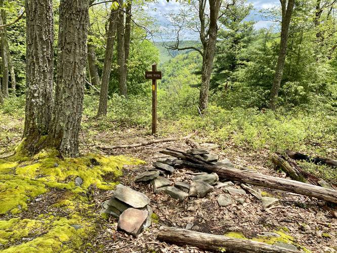
The trail finally descends slightly downhill toward the vista point at a gradual grade. At Gore Vista, hikers will find a campsite with a fire ring; however, the campsite is fairly small and can only accommodate one or two small tents.
Gore Vista
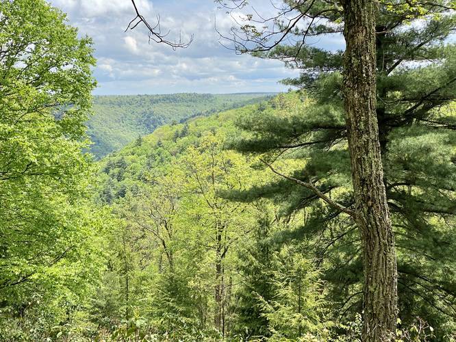
At the end of the trail is the main destination for this hike - Gore Vista. The vista point can be viewed from the sign post near the campsite; however, hikers will find a better view if they hike down along a skinny trail that leads into the open space where the state has cleared out more trees for the vista.
Backpacking and Camping
Backpackers can camp along this trail and at the vista point, but must follow all PA State Forest and Wild Area rules and regulations regarding camping and fires.
Parking
Hikers can find a small parking turnout on the right-hand side of the road near the parking coordinates provided.
Road Maintenance
Note that this road is not maintained during the winter. During the Spring and wetter months, the road can have very large potholes and ruts, so hikers should plan to bring a high-clearance vehicle.
Pets
Dogs are allowed if leashed.
Blaze Color
Hikers should note that this trail follows red blazes to begin with and then the trail switches over to yellow blazes.
This trail starts by following red blazes as it makes it way deeper into the Quehanna wilderness. Not far after the hike begins, the trail will take a left-hand turn at the first junction; however, in May 2020 there was signage at each junction leading out to the vista which makes the hike easier.
The trail will undulate slightly as it makes it way past one more trail junction before leading out to the mountain ridge. At the second and last trail junction is where the blaze color turns from red to yellow.
The trail finally descends slightly downhill toward the vista point at a gradual grade. At Gore Vista, hikers will find a campsite with a fire ring; however, the campsite is fairly small and can only accommodate one or two small tents.
Gore Vista
At the end of the trail is the main destination for this hike - Gore Vista. The vista point can be viewed from the sign post near the campsite; however, hikers will find a better view if they hike down along a skinny trail that leads into the open space where the state has cleared out more trees for the vista.
Backpacking and Camping
Backpackers can camp along this trail and at the vista point, but must follow all PA State Forest and Wild Area rules and regulations regarding camping and fires.
Parking
Hikers can find a small parking turnout on the right-hand side of the road near the parking coordinates provided.
Road Maintenance
Note that this road is not maintained during the winter. During the Spring and wetter months, the road can have very large potholes and ruts, so hikers should plan to bring a high-clearance vehicle.
Pets
Dogs are allowed if leashed.
Blaze Color
Hikers should note that this trail follows red blazes to begin with and then the trail switches over to yellow blazes.