Goldmine Brook Falls at Chester-Blandford State Forest in Chester, Massachusetts is a moderate 0.2-mile out-and-back hike that leads to the 40-foot tall two-tiered waterfall known as Goldmine Brook Falls.
Hike Description
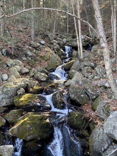
This hike begins on the south side of US-20, just west of the parking coordinates provided, and heads up a steep hill initially to head into the forest. Once on the trail, it follows an easy grade for a few-hundred feet before it reaches a viewpoint of smaller waterfalls within Goldmine Brook. Some of these waterfalls are ~7 or 8-feet tall and while small, they fill in the scenic gorge below.
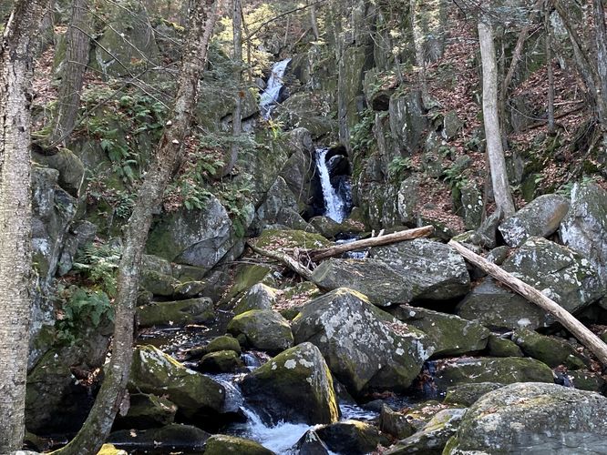
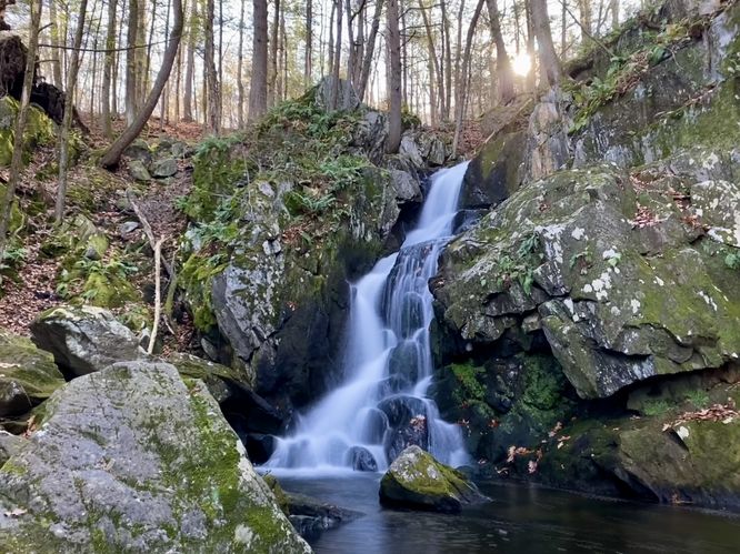
The trail becomes much steeper as it ascends the hill, following the gorge on the eastern side. Along the way are more viewpoints of the gorge, brook, and small waterfalls. Eventually the entire 40-foot Goldmine Brook Falls comes into view from downstream with its two-tiers cascading down the brook. A bit more uphill hiking is required to reach a ledge trail that leads to the base of the waterfall.
Goldmine Brook Falls View - Mile 0.06 to 0.07
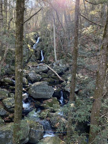
About half-way through the hike to the base of the upper portion of Goldmine Brook Falls, hikers will find a downstream viewing area of the entire cascade. Note that these viewpoints lie between miles 0.06 and 0.07 -- the entire waterfall is mostly visible during cold months when there are no leaves on the trees.
Goldmine Brook Falls - Mile 0.1
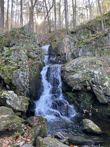
Around mile 0.1, hikers will find a skinny ledge trail that leads to off from the main path and out to the base of the upper part of Goldmine Brook Falls. Watch your step as you traverse the often wet and slick bedrock to reach a viewing area of the waterfall. From the base of Goldmine Brook Falls, hikers can snap photos of the 30-foot cascade within the gorge. Just below your feet is the lower section of Goldmine Brook Falls, as it cascades down the gorge at about ~10-feet tall in total. The combination of both cascades forms the 40-foot tall Goldmine Brook Falls. After visiting the waterfall, the hike out follows the same path that you hiked-in on. Watch your step along the trail as it's often covered in wet slippery leaves that cover the bedrock.
Parking
Hikers will find a large parking turnout at the coordinates provided, located along the north side of US-20 -- just east of the trailhead. The turnout is large enough to fit at least a dozen cars.
Pets
Dogs are allowed only if leashed and must be cleaned up after.
Warnings
Steep ledges and cliffs: This hike follows along steep ledges and cliffs that plunge into the gorge below. Watch your step and keep back to prevent injury or worse.
Slick leaves on bedrock: The trail leads up sections of bedrock that are often covered in wet, slippery leaves. Watch your step, use nearby trees to help balance, or bring trekking poles to ensure a safer hike.
Timber Rattlesnakes: Massachusetts is home to the Timber Rattlesnake. While they're very rare to find in Massachusetts, they do roam the remote forests between the end of April to early October each year. Snakes will use the brooks to hunt prey or drink water. Be on the lookout and if you find any rattlers, give them plenty of space.
Hike Description
This hike begins on the south side of US-20, just west of the parking coordinates provided, and heads up a steep hill initially to head into the forest. Once on the trail, it follows an easy grade for a few-hundred feet before it reaches a viewpoint of smaller waterfalls within Goldmine Brook. Some of these waterfalls are ~7 or 8-feet tall and while small, they fill in the scenic gorge below.
The trail becomes much steeper as it ascends the hill, following the gorge on the eastern side. Along the way are more viewpoints of the gorge, brook, and small waterfalls. Eventually the entire 40-foot Goldmine Brook Falls comes into view from downstream with its two-tiers cascading down the brook. A bit more uphill hiking is required to reach a ledge trail that leads to the base of the waterfall.
Goldmine Brook Falls View - Mile 0.06 to 0.07
About half-way through the hike to the base of the upper portion of Goldmine Brook Falls, hikers will find a downstream viewing area of the entire cascade. Note that these viewpoints lie between miles 0.06 and 0.07 -- the entire waterfall is mostly visible during cold months when there are no leaves on the trees.
Goldmine Brook Falls - Mile 0.1
Around mile 0.1, hikers will find a skinny ledge trail that leads to off from the main path and out to the base of the upper part of Goldmine Brook Falls. Watch your step as you traverse the often wet and slick bedrock to reach a viewing area of the waterfall. From the base of Goldmine Brook Falls, hikers can snap photos of the 30-foot cascade within the gorge. Just below your feet is the lower section of Goldmine Brook Falls, as it cascades down the gorge at about ~10-feet tall in total. The combination of both cascades forms the 40-foot tall Goldmine Brook Falls. After visiting the waterfall, the hike out follows the same path that you hiked-in on. Watch your step along the trail as it's often covered in wet slippery leaves that cover the bedrock.
Parking
Hikers will find a large parking turnout at the coordinates provided, located along the north side of US-20 -- just east of the trailhead. The turnout is large enough to fit at least a dozen cars.
Pets
Dogs are allowed only if leashed and must be cleaned up after.
Warnings
Steep ledges and cliffs: This hike follows along steep ledges and cliffs that plunge into the gorge below. Watch your step and keep back to prevent injury or worse.
Slick leaves on bedrock: The trail leads up sections of bedrock that are often covered in wet, slippery leaves. Watch your step, use nearby trees to help balance, or bring trekking poles to ensure a safer hike.
Timber Rattlesnakes: Massachusetts is home to the Timber Rattlesnake. While they're very rare to find in Massachusetts, they do roam the remote forests between the end of April to early October each year. Snakes will use the brooks to hunt prey or drink water. Be on the lookout and if you find any rattlers, give them plenty of space.