Loading...

๐ŸŽ‰ Enjoy a Free 7-Day Supporter Trial and Unlock Exclusive Perks โ€” No Credit Card Required. Learn more.

Gleason Falls Trail

Directions
Map
Pictures
Send to App
Distance:
0.1 Miles / 0.2 km
Type:
Out-and-Back
Difficulty:
Easy
Time to Hike:
~5 minutes
Features:
Surface Type:
Dirt
Town:
Hillsborough, New Hampshire
Directions:
43.143491, -71.95571
Added:
July 12, 2024
Updated:
July 29, 2024
Copy Trail Link Hiking this trail? Send a friend or family member a link to this trail guide for your own safety. Hike at your own risk (disclaimer)
Loading...
Loading...
20'

Total Change
22'

Ascent
22'

Descent

Download the Trail Route for Offline Use

Supporters get exclusive access to download trail routes to the MyHikes app for offline use. Stay prepared on your adventure, even without an internet connection! Become a Supporter today to unlock this feature and hike with confidence.

Send to App

Gleason Falls Trail

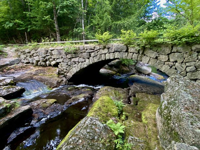
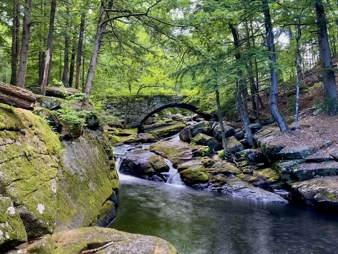
The Gleason Falls Trail in Hillsborough, New Hampshire is an easy 0.1-mile out-and-back trail that leads to a scenic stone bridge that sits above a multi-tiered waterfall known as Gleason Falls.

Walk
This is not a hike but rather a short walk to the ultra-scenic Gleason Falls. Gleason Falls was donated in 1967 by Raymond J & Rena M Hooper so everyone can enjoy it. The main trail can be found at the small parking turnout. The trail leads into the forest for ~200-feet to several viewpoints of Gleason Falls in the rocky gorge below. Gleason Falls sits below a beautiful stone bridge, which just adds to the stunning forest scenery. After exploring the waterfall, you can hike back to parking and head across the road to find a view of small cascades and the western side of the stone bridge.

Parking
Visitors will find a tiny parking turnout at the coordinates provided, located along Beard Road in Hillsborough, NH. The turnout is large enough to fit 2 vehicles as of July 2024.

Pets
Dogs are allowed only if leashed and should be cleaned up after.
Explore 81 trails near Hillsborough, NH
  1. Parking

    43.143491, -71.95571
  2. Main Trailhead

    43.143491, -71.95571
  3. North side of Gleason Falls and bridge

    43.143622, -71.955881
    North side of Gleason Falls and bridge
  4. Gleason Falls and scenic stone bridge

    43.143703, -71.955306
    Gleason Falls and scenic stone bridge
No community routes found. To add your own hike as a Community Route for this Trail guide, leave a Trip Report with an attached GPX file.

Hazards

Ticks - Lyme Disease More Info (CDC)

Seasons

All

Trip Reports

Trail Guide By:
Admin user profile picture
0.1 miles / 0.2 km
0.1 miles / 0.2 km
July 12, 2024
Super scenic waterfall and stone bridge. We showed up to find just one other person at the waterfall. They left shortly after and we had the waterfall all to ourselves.
Dogs Hiking

Weather Forecast

In Hillsborough, NH

Explore Hiking Trails

You May Also Like

Colorado's Million Dollar Highway - Plan a day's drive adventure along the iconic Million Dollar Highway in Colorado. Explore the best short trails, roadside stops, waterfalls, vistas, ghost towns, and hot springs within a ~6 hour road trip.
Explore

Colorado's Million Dollar Highway

Plan a day's drive adventure along the iconic Million Dollar Highway in Colorado. Explore the best short trails, roadside stops, waterfalls, vistas, ghost towns, and hot springs within a ~6 hour road trip.

Read
Glacier's Going-to-the-Sun Road - Discover the breathtaking beauty of Glacier National Park along the iconic Going-to-the-Sun Road. From stunning roadside stops to picturesque waterfalls and vistas, this engineering marvel offers endless opportunities for exploration.
Explore

Glacier's Going-to-the-Sun Road

Discover the breathtaking beauty of Glacier National Park along the iconic Going-to-the-Sun Road. From stunning roadside stops to picturesque waterfalls and vistas, this engineering marvel offers endless opportunities for exploration.

Read
New York's Best Waterfalls - Whether you're planning a day hike, roadside stop, or a leisurely short walk, this guide provides hikers, travelers, and locals alike with 63 different locations to over 100 scenic waterfalls to help plan your next adventure!
Explore

New York's Best Waterfalls

Whether you're planning a day hike, roadside stop, or a leisurely short walk, this guide provides hikers, travelers, and locals alike with 63 different locations to over 100 scenic waterfalls to help plan your next adventure!

Read

Before you boogie...

Find our trail guides useful? Consider becoming a Supporter to unlock perks!

MyHikes is an indie platform that makes exploring public trails easier for everyone. The platform has no investors, no ads, and is owned and operated by one person, Dave Miller. Dave has personally mapped and written over 1,800 trail guides on MyHikes for the public to explore. MyHikes has helped millions outdoor enthusiasts plan their next adventure.

But it takes a lot of time ๐Ÿ•ฆ, money ๐Ÿ’ฐ, work, and espresso shots โ˜• to run MyHikes, including hiking , mapping , writing , and publishing new trails with high-quality (accurate) information... along with software engineering (coding) the platform like building new features, website and mobile app development (iOS and Android), site maintainance . and much much more.

Supporters unlock website and mobile app perks with an annual one-time payment of $25 (you renew) ๐Ÿ˜Ž๐Ÿ‘. Or you can simply make a Donation of your choice. Otherwise, you can support us by telling your friends about MyHikes - both quick and free ๐ŸŽ‰

Admin user profile picture

Dave Miller
MyHikes Founder