Loading...

🎉 Enjoy a Free 7-Day Supporter Trial and Unlock Exclusive Perks — No Credit Card Required. Learn more.

Giant's Washbowl, Nubble, Roaring Brook Falls Hike

Directions
Map
Pictures
Send to App
Distance:
5.4 Miles / 8.7 km
Type:
Loop
Difficulty:
Hard
Time to Hike:
2 hours, ~42 minutes
Features:
Surface Type:
Dirt
Park:
Adirondack Park
Town:
Keene Valley, New York
Directions:
44.15043, -73.767512
Added:
October 17, 2024
Updated:
June 11, 2025
Copy Trail Link Hiking this trail? Send a friend or family member a link to this trail guide for your own safety. Hike at your own risk (disclaimer)
Loading...
Loading...
1,580'

Total Change
1,821'

Ascent
1,892'

Descent

Download the Trail Route for Offline Use

Supporters get exclusive access to download trail routes to the MyHikes app for offline use. Stay prepared on your adventure, even without an internet connection! Become a Supporter today to unlock this feature and hike with confidence.

Send to App

Giant's Washbowl, Nubble, Roaring Brook Falls Hike

The Giant's Washbowl, Nubble, and Roaring Brook Falls hike at Adirondack Park in Keene Valley, New York is a difficult, popular, 5.4-mile loop / out-and-back combo hike that features stunning views from Giant Mountain's southwestern slopes.

Trail names: Roaring Brook Falls Trail, Nubble Trail, Ridge Trail, Washbowl Trail, Upper Falls Lookout Spur, Lower Falls Trail

Location: Route 73,  Keene, NY

Permitted uses: Hiking, Nature Study, Camping at designated areas, camping for more than 3 consecutive nights or in a group of 10 or more requires a permit from a DEC land manager. Fishing, Trapping and hunting with a proper license. Cross country skiing, Snowshoeing.

Prohibited uses: No Bicycles, No motorized equipment,

Hours: There are no posted hours.

Fees and Parking: There is no fee to park or to use the trails. Parking is off of Route 73 and there is enough parking for at least 16 vehicles. The parking lot does fill up quickly.

Pets: Dogs are allowed on the trail as long as they are on a leash.

Accessibility: These trails are not wheelchair accessible.

Hiker amenities: There is a gender neutral portable bathroom at the parking lot. There are no trash bins and no water. There is an information kiosk with a posted map. There is also a shoe brush installed at the trailhead. The brush is installed as an attempt to prevent the unintentional introduction of invasive species to this wilderness. Hikers are encouraged to brush off their shoes before and after hiking. Hikers are encouraged to Register their visit at the start and end of their visit.

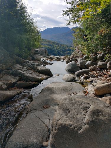
Length and Trail information: The hike was done as a loop hike and was approximately 5.36 miles long. The trail is easy to start but gets progressively harder. Along the Beede Brook the trail is wide and flat and easy to hike. Once the ascent begins, the footing becomes more challenging and hikers will need to traverse rocks, roots and Roaring Brook along the trail. The hike is well marked with red and yellow trail blazes and engraved wooden signs at most junctions. We chose to save the hike to the Top of the Falls and the Base of the Falls for the end of our hike.

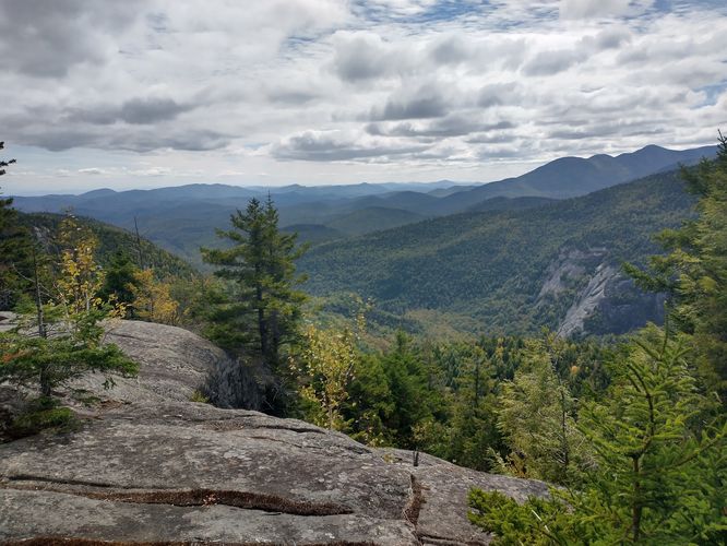
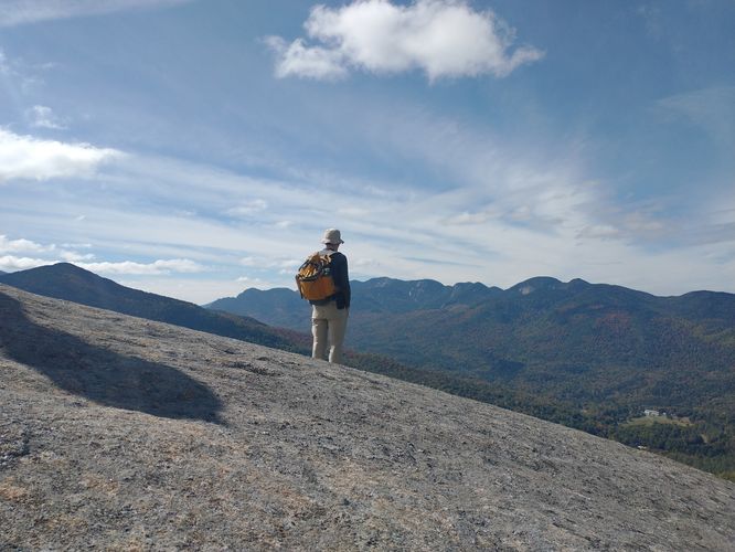
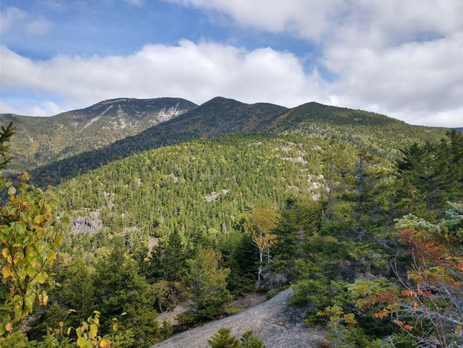
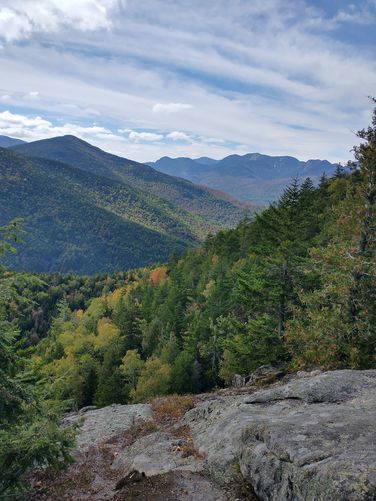
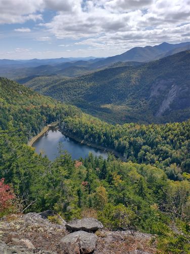
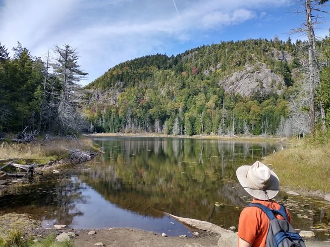
We started off by hiking the Roaring Brook Trail to the Washbowl Trail to connect to the Nubble Trail. There is steady elevation with this hike and the terrain can be tricky. There are lots of rocks to navigate and occasionally downed trees, but the views from the Giant's Nubble are spectacular. The panoramic views from this rocky summit at 2734 feet are worth all the effort needed to get there. After our stop at the Giants Nubble we continued on the Nubble Trail. The Nubble Trail offers some really nice aerial views of the Giant's Washbowl below but they are not as jaw dropping as the views from the Giant's Nubble. From the Nubble Trail we hiked down to the steep Ridge Trail and then continued down to the Washbowl Trail to check out the views of the Giant's Washbowl from its tranquil shoreline. The Giant's Washbowl is a popular fishing spot that is stocked with native brook trout. The pond is 4.2 acres in size and has a maximum depth of 23 feet. From the Giant's Washbowl Trail we hiked back down to the Roaring Brook Trail to connect to the Roaring Brook Falls Upper Lookout.

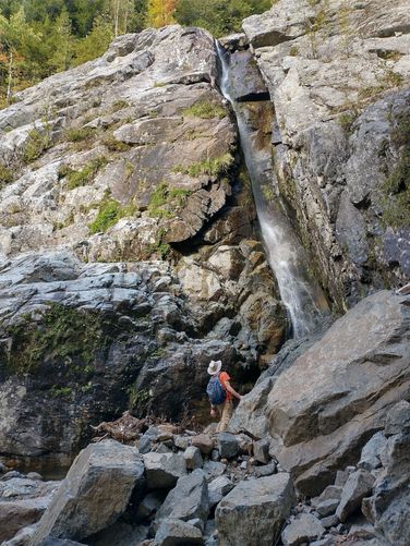
The view from the Top of the Falls is beautiful, but surprisingly, you can't actually see much of the waterfall from the top: the drop off is dangerously steep and the flowing water drops through a rocky crevasse and disappears from view. From the Fall Lookout we returned to the Roaring Brook Trail and went down to see the Falls from the base of the waterfall. The best view of the waterfall is at the base, and it's the easiest part of the hike. The hike to the base of the Roaring Brook Falls is short, easy and offers beautiful views of the 130 foot high falls. Hikers able to do a bit of rock scrambling will be rewarded with stunning views of the waterfall.

Explore 35 trails near Keene Valley, NY
  1. Parking

    44.15043, -73.767512
  2. Main Trailhead

    44.150396, -73.767212
  3. Beautiful views

    44.145964, -73.743227
    Beautiful views
  4. View from Giant's Nubble Summit

    44.146734, -73.744614
    View from Giant's Nubble Summit
  5. View of Giant Mountain from Nubble's summit

    44.146788, -73.744392
    View of Giant Mountain from Nubble's summit
  6. Beautiful views into the High Peaks Wilderness from Nubble's summit

    44.146739, -73.744998
    Beautiful views into the High Peaks Wilderness from Nubble's summit
  7. Aerial view of the Giant's Washbowl

    44.145752, -73.741222
    Aerial view of the Giant's Washbowl
  8. The Giant's Washbowl from the shore

    44.142147, -73.739083
    The Giant's Washbowl from the shore
  9. View from the Upper Falls Lookout

    44.150657, -73.76005
    View from the Upper Falls Lookout
  10. The 130 foot tall Roaring Brook Falls

    44.150387, -73.760624
    The 130 foot tall Roaring Brook Falls
No community routes found. To add your own hike as a Community Route for this Trail guide, leave a Trip Report with an attached GPX file.

Hazards

Ticks - Lyme Disease More Info (CDC)
Snakes
Poison Ivy/Oak
Rockfalls / Ledges / or Scrambles

Seasons

All

Blaze Color

Red

Blaze Dot

Yellow

Weather Forecast

In Keene Valley, NY

Explore Hiking Trails

You May Also Like

Colorado's Million Dollar Highway - Plan a day's drive adventure along the iconic Million Dollar Highway in Colorado. Explore the best short trails, roadside stops, waterfalls, vistas, ghost towns, and hot springs within a ~6 hour road trip.
Explore

Colorado's Million Dollar Highway

Plan a day's drive adventure along the iconic Million Dollar Highway in Colorado. Explore the best short trails, roadside stops, waterfalls, vistas, ghost towns, and hot springs within a ~6 hour road trip.

Read
Glacier's Going-to-the-Sun Road - Discover the breathtaking beauty of Glacier National Park along the iconic Going-to-the-Sun Road. From stunning roadside stops to picturesque waterfalls and vistas, this engineering marvel offers endless opportunities for exploration.
Explore

Glacier's Going-to-the-Sun Road

Discover the breathtaking beauty of Glacier National Park along the iconic Going-to-the-Sun Road. From stunning roadside stops to picturesque waterfalls and vistas, this engineering marvel offers endless opportunities for exploration.

Read
New York's Best Waterfalls - Whether you're planning a day hike, roadside stop, or a leisurely short walk, this guide provides hikers, travelers, and locals alike with 63 different locations to over 100 scenic waterfalls to help plan your next adventure!
Explore

New York's Best Waterfalls

Whether you're planning a day hike, roadside stop, or a leisurely short walk, this guide provides hikers, travelers, and locals alike with 63 different locations to over 100 scenic waterfalls to help plan your next adventure!

Read

Before you boogie...

Find our trail guides useful? Consider becoming a Supporter to unlock perks!

MyHikes is an indie platform that makes exploring public trails easier for everyone. The platform has no investors, no ads, and is owned and operated by one person, Dave Miller. Dave has personally mapped and written over 1,800 trail guides on MyHikes for the public to explore. MyHikes has helped millions outdoor enthusiasts plan their next adventure.

But it takes a lot of time 🕦, money 💰, work, and espresso shots ☕ to run MyHikes, including hiking , mapping , writing , and publishing new trails with high-quality (accurate) information... along with software engineering (coding) the platform like building new features, website and mobile app development (iOS and Android), site maintainance . and much much more.

Supporters unlock website and mobile app perks with an annual one-time payment of $25 (you renew) 😎👍. Or you can simply make a Donation of your choice. Otherwise, you can support us by telling your friends about MyHikes - both quick and free 🎉

Admin user profile picture

Dave Miller
MyHikes Founder