Giant Ledge at Catskill Park within the Slide Mountain Wilderness Area near Shandaken, New York is a moderate 3.4-mile out-and-back hike that leads to a stunning vista point along a massive mountain ledge which sits on Panther Mountain's south ridge.
Trails
This hike follows two trails: Phoenicia East Branch Trail (yellow blazes),
Hike Description
This hike starts out at the hairpin turn on Oliverea-Slide Mountain Road and follows yellow blazes of the Phoenicia East Branch Trail as it ascends a mountain hollow. Along the way is a wooden footbridge that crosses a brook, along with plenty of rocky terrain to keep the hiker aware of their footing. The trail's substrate leading up the mountain hollow is mostly medium-sized rocks.
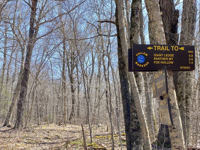
Junction to Giant Ledge - Mile 0.8
Around mile 0.8, hikers will reach a rock ledge where the trail runs up and around. Once at the top of the ledge, hikers will find a trail junction located ~100-feet east. At this trail junction, hikers will begins to follow the blue blazes of the Giant Ledge-Panther Mountain Trail. At this junction, hikers will also get a nice break from the mountain ascent as the trail begins to follow a flatter elevation grade for approximately 0.5-miles.
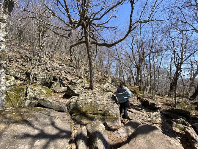
Giant Ledge Ascent - Mile 1.4
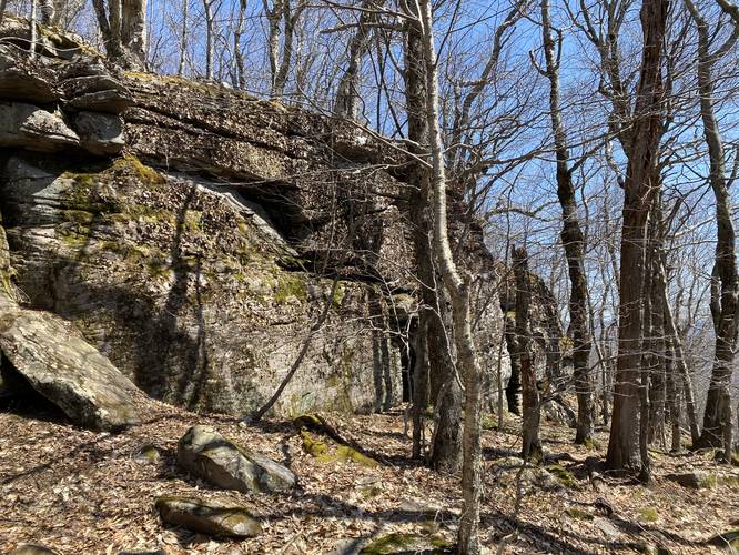
At mile 1.4, hikers will reach the beginning of the Giant Ledge; however, this requires hiking up a fairly-steep and rocky trail. This section of steep rocks ends approximately 0.2-miles later where the southern section of the mountain saddle (Giant Ledge) finally flattens out. Just before the trail flattens out, hikers will find a 15-foot tall rock ledge right off-trail, which gives an interesting view of a tiny section of the Giant Ledge.
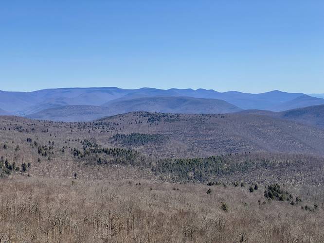
Giant Ledge Vista - Mile 1.7
After following the trail for about 0.1-mile upon ascending the southern mountain saddle of Giant Ledge, hikers will reach the first vista / overlook located along Giant Ledge at mile 1.7. This is where the GPS recording stopped (where we decided to turn around and hike back); however, there are more vistas along Giant Ledge, allowing hikers to spread out in this very-popular hiking spot.
Hiking Out
The hike out is the opposite of the hike in and is generally a bit easier and faster going downhill. Watch your steps in the steep rocky sections and take your time on the hike out.
Popularity
This is one of the more popular hikes within the Catskills, so showing up early to ensure you get a parking spot (and the potential for solitude) is a must-do on weekends. Upon our visit (after driving 3.5+ hours), we showed up in late April around 10AM to find the main parking lot full with about 10 cars. By the time we finished the hike, 2 hours later, there were ~30 cars parked, overflowing the lot and filling the road.
Parking
Hikers will find a large parking lot at the coordinates provided which is large enough to fit about 10 cars. There are several smaller turnouts just down the road that hikers can use for parking as well. In total, it seems folks can fit about 30 vehicles including the additional parking turnouts.
Pets
Dogs are allowed if leashed and their waste should be carried out by the hiker. Note that due to popularity, this is not a great trail for leash-reactive dogs.
Trails
This hike follows two trails: Phoenicia East Branch Trail (yellow blazes),
Hike Description
This hike starts out at the hairpin turn on Oliverea-Slide Mountain Road and follows yellow blazes of the Phoenicia East Branch Trail as it ascends a mountain hollow. Along the way is a wooden footbridge that crosses a brook, along with plenty of rocky terrain to keep the hiker aware of their footing. The trail's substrate leading up the mountain hollow is mostly medium-sized rocks.
Junction to Giant Ledge - Mile 0.8
Around mile 0.8, hikers will reach a rock ledge where the trail runs up and around. Once at the top of the ledge, hikers will find a trail junction located ~100-feet east. At this trail junction, hikers will begins to follow the blue blazes of the Giant Ledge-Panther Mountain Trail. At this junction, hikers will also get a nice break from the mountain ascent as the trail begins to follow a flatter elevation grade for approximately 0.5-miles.
Giant Ledge Ascent - Mile 1.4
At mile 1.4, hikers will reach the beginning of the Giant Ledge; however, this requires hiking up a fairly-steep and rocky trail. This section of steep rocks ends approximately 0.2-miles later where the southern section of the mountain saddle (Giant Ledge) finally flattens out. Just before the trail flattens out, hikers will find a 15-foot tall rock ledge right off-trail, which gives an interesting view of a tiny section of the Giant Ledge.
Giant Ledge Vista - Mile 1.7
After following the trail for about 0.1-mile upon ascending the southern mountain saddle of Giant Ledge, hikers will reach the first vista / overlook located along Giant Ledge at mile 1.7. This is where the GPS recording stopped (where we decided to turn around and hike back); however, there are more vistas along Giant Ledge, allowing hikers to spread out in this very-popular hiking spot.
Hiking Out
The hike out is the opposite of the hike in and is generally a bit easier and faster going downhill. Watch your steps in the steep rocky sections and take your time on the hike out.
Popularity
This is one of the more popular hikes within the Catskills, so showing up early to ensure you get a parking spot (and the potential for solitude) is a must-do on weekends. Upon our visit (after driving 3.5+ hours), we showed up in late April around 10AM to find the main parking lot full with about 10 cars. By the time we finished the hike, 2 hours later, there were ~30 cars parked, overflowing the lot and filling the road.
Parking
Hikers will find a large parking lot at the coordinates provided which is large enough to fit about 10 cars. There are several smaller turnouts just down the road that hikers can use for parking as well. In total, it seems folks can fit about 30 vehicles including the additional parking turnouts.
Pets
Dogs are allowed if leashed and their waste should be carried out by the hiker. Note that due to popularity, this is not a great trail for leash-reactive dogs.