Loading...

🎆 50% off 4th of July sale on Supporter Accounts — now through July 6! Learn More.

Gate WR25

Directions
Map
Pictures
Send to App
Distance:
3.7 Miles / 6.0 km
Type:
Out-and-Back
Difficulty:
Easy
Time to Hike:
1 hour, ~51 minutes
Surface Type:
Dirt
Park:
Quabbin Reservoir
Town:
Ware, Massachusetts
Directions:
42.285622, -72.335628
Added:
January 29, 2021
Updated:
January 30, 2021
Copy Trail Link Hiking this trail? Send a friend or family member a link to this trail guide for your own safety. Hike at your own risk (disclaimer)
Loading...
Loading...
158'

Total Change
165'

Ascent
165'

Descent

Download the Trail Route for Offline Use

Supporters get exclusive access to download trail routes to the MyHikes app for offline use. Stay prepared on your adventure, even without an internet connection! Become a Supporter today to unlock this feature and hike with confidence.

Send to App

Gate WR25

Gate WR25 at Quabbin Reservoir is an easy 3.7-mile out-and-back trail located on Windsor Dam Rd off Route 9 in Ware, Massachusetts. The trail is 1.8 miles one-way to Administration Rd or a 3.7-mile out and back hike in total.

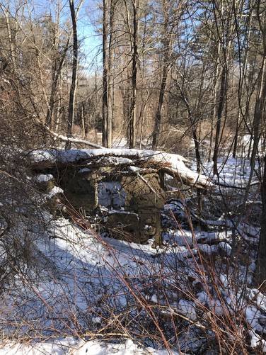
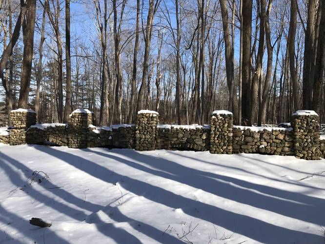
The first leg of the trail which is also called the Observation Tower Trail is a slow, winding climb by old stone walls and young pine growth for 0.6-miles until the trail meets up with Webster Rd. Along Webster Rd, hikers can enjoy old foundations and stone walls, ancient trees and Quabbin's wildlife. While there is elevation gain until you reach Administration Rd, it's so gradual that it's unnoticeable and it's a straight line of a hike with 1.2 miles to the road. From Administration Rd, you can access Hank's Meadow or turn around and head south towards the gate. There are also several side trails leading towards Quabbin Tower along Webster Rd.

Difficulty
The trail should be considered easy, it is both wide and the elevation changes are minimal.

Blazes
There are no blazes or trail signs on this route.

Parking and Trailhead Location
Hikers will find the trailhead on the eastern end of the parking lot near the coordinates provided. The main parking lot is large enough to fit about a dozen vehicles.

Pets
Dogs are not allowed on any trails at Quabbin Reservoir.
Explore 206 trails near Ware, MA
  1. Parking

    42.285622, -72.335628
  2. Main Trailhead

    42.285642, -72.335317
  3. Old stone foundation

    42.300786, -72.326736
    Old stone foundation
  4. Old stonewall

    42.305683, -72.325522
    Old stonewall
No community routes found. To add your own hike as a Community Route for this Trail guide, leave a Trip Report with an attached GPX file.

Hazards

Ticks - Lyme Disease More Info (CDC)
Poison Ivy/Oak

Seasons

All

Weather Forecast

In Ware, MA

Explore Hiking Trails

You May Also Like

Colorado's Million Dollar Highway - Plan a day's drive adventure along the iconic Million Dollar Highway in Colorado. Explore the best short trails, roadside stops, waterfalls, vistas, ghost towns, and hot springs within a ~6 hour road trip.
Explore

Colorado's Million Dollar Highway

Plan a day's drive adventure along the iconic Million Dollar Highway in Colorado. Explore the best short trails, roadside stops, waterfalls, vistas, ghost towns, and hot springs within a ~6 hour road trip.

Read
Glacier's Going-to-the-Sun Road - Discover the breathtaking beauty of Glacier National Park along the iconic Going-to-the-Sun Road. From stunning roadside stops to picturesque waterfalls and vistas, this engineering marvel offers endless opportunities for exploration.
Explore

Glacier's Going-to-the-Sun Road

Discover the breathtaking beauty of Glacier National Park along the iconic Going-to-the-Sun Road. From stunning roadside stops to picturesque waterfalls and vistas, this engineering marvel offers endless opportunities for exploration.

Read
New York's Best Waterfalls - Whether you're planning a day hike, roadside stop, or a leisurely short walk, this guide provides hikers, travelers, and locals alike with 63 different locations to over 100 scenic waterfalls to help plan your next adventure!
Explore

New York's Best Waterfalls

Whether you're planning a day hike, roadside stop, or a leisurely short walk, this guide provides hikers, travelers, and locals alike with 63 different locations to over 100 scenic waterfalls to help plan your next adventure!

Read

Before you boogie...

Find our trail guides useful? Consider becoming a Supporter to unlock perks!

MyHikes is an indie platform that makes exploring public trails easier for everyone. The platform has no investors, no ads, and is owned and operated by one person, Dave Miller. Dave has personally mapped and written over 1,800 trail guides on MyHikes for the public to explore. MyHikes has helped millions outdoor enthusiasts plan their next adventure.

But it takes a lot of time 🕦, money 💰, work, and espresso shots ☕ to run MyHikes, including hiking , mapping , writing , and publishing new trails with high-quality (accurate) information... along with software engineering (coding) the platform like building new features, website and mobile app development (iOS and Android), site maintainance . and much much more.

Supporters unlock website and mobile app perks with an annual one-time payment of $25 (you renew) 😎👍. Or you can simply make a Donation of your choice. Otherwise, you can support us by telling your friends about MyHikes - both quick and free 🎉

Admin user profile picture

Dave Miller
MyHikes Founder