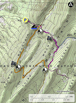
Fridley Gap in the George Washington National Forest has
a little bit of everything. From gentle mountain streams, to
ridge climbs and a great swimming hole
this hike has it all. Located at the southern end of the Massanutten
range just east of Harrisonburg Virginia the hike is secluded. Consider
taking a swim at the Fridley Gap swimming hole which is perfect on a hot
summer day a 1/2 mile from the parking area, but remember this is cold
mountain water anytime of the year!
- Mile 0.0 - From the parking area on Airey Road walk up to the trailhead of the Fridley Gap Trail where the road turns left towards private property. Follow the Fridley Gap Trail next to Mountain Run on the left bank. The trail will climb through the gap and pass a side trail on the left. This leads to the private road up from the parking area. Continue upstream on the Fridley Gap trail crossing through Mountain Run twice.
- Mile 0.46 - Arrive at the swimming hole. This large pool and table rock falls is a perfect place to take a swim on a hot summer day. From the swimming hole there is a campsite directly upstream, and the intersection with the Massanutten South Trail is in another 100 yards.
- Mile 0.5 - Arrive at the intersection with the orange blazed Massanutten South Trail. Turn right crossing the run. There will be another larger campsite just upstream from this crossing. Continue on the orange trail south as it begins to climb on the eastern side of Fourth Mountain. In 1.4 miles from the run the trail will arrive at the ridge, with an unmarked side trail to a rock outcropping and view westward towards the Harrisonburg valley. There is also a campsite at the saddle here.
- Mile 1.9 - Continue south on the orange Massanutten South Trail as it follows the ridge then makes two switchbacks and descends to Fridley Run. Across the run is a small camping area. Continue upstream for 60 yards then cross Fridley Run. The trail then turns back to the north and climbs on the western side of Third Mountain. Pass over the ridge of Third Mountain and through a small open area. The trail now follows a wider path that also serves as a forestry road, and descends for 0.3 miles to the 4-way intersection with the purple blazed Fridley Gap Trail.
- Mile 3.9 - At the 4-way intersection the Massanutten South Trail turns right, with the Fridley Gap Trail coming n from the left and continuing straight. Turn left at this intersection onto the purple blazed Fridley Gap Trail. The Fridley Gap Trail follows a gravel forestry road at this point. The trail will descend for 0.7 miles and arrive at the intersection where the Fridley Gap Trail turns off the forestry road left uphill, and the forestry road continues as the blue blazed Martin Bottom Trail.
- Mile 4.6 - Turn left off the gravel forestry road as the purple blazed Fridley Gap Trail now starts climbing Third Mountain. The trail is rocky and steep and makes several small switchbacks then arrives at the ridge in 0.35 miles. Descend the steep western side of Third Mountain for 0.3 miles where there is a large rock stack 70 yards off the left side of the trail. From the top of the stack there is an excellent view through Fridley Gap to the west. Note: There is no trail to the stack, so if you decide to bushwack to the overlook be careful to look for rattlesnakes in the warmer months. The trail continues downhill and is rocky with only a couple of switchbacks before levelling out, and arriving at the intersection with the orange blazed Massanutten South Trail.
- Mile 5.6 - Turn left on the orange blazed Massanutten Trail for 0.1 miles back to Mountain Run and the intersection with Fridley Gap Trail you hiked up earlier.
- Mile 5.7 - Turn right downstream on the Fridley Gap Trail passing the swimming hole on the left. Retrace your route back to Airey Rd. and the parking area.
- Mile 6.2 - Arrive back at the parking area on Airey Rd.