Freeland Boardwalk Trail
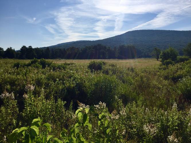
While the trail's description may not sound very appealing, this boardwalk hike is actually really nice since it passes through the open fields of Canaan Valley, which sits right below the Dolly Sods Wilderness.
Dogs are not allowed on this trail.
Know Before You Go
Interactive topographic map for Freeland Boardwalk Trail located in Davis, WV. Click the "View Map" button to load GPS coordinates and trail markers.
View map
Get directions
- Distance
- 0.5 mi
- Difficulty
- Easy
- Type
- Loop
- Est. Time
- 15 min
- Elev. Gain
- 16'
- Rating
- 0.0
- Added
- July 29, 2018
- Updated
- January 23, 2020
Weather Forecast
Tonight
Low
63°F
Mostly Cloudy then Slight Chance Rain Showers
Tuesday
High
76°F
Slight Chance Showers And Thunderstorms then Chance Showers And Thunderstorms
Tuesday Night
Low
61°F
Chance Showers And Thunderstorms then Showers And Thunderstorms
Wednesday
High
70°F
Showers And Thunderstorms Likely
Wednesday Night
Low
49°F
Chance Showers And Thunderstorms then Partly Cloudy
Thursday
High
70°F
Sunny
Thursday Night
Low
51°F
Mostly Clear
Friday
High
73°F
Mostly Sunny
Friday Night
Low
56°F
Mostly Cloudy
Saturday
High
74°F
Slight Chance Rain Showers then Slight Chance Showers And Thunderstorms
Saturday Night
Low
58°F
Slight Chance Showers And Thunderstorms
Sunday
High
77°F
Slight Chance Rain Showers then Slight Chance Showers And Thunderstorms
Sunday Night
Low
60°F
Slight Chance Showers And Thunderstorms then Chance Showers And Thunderstorms
Monday
High
77°F
Chance Rain Showers then Chance Showers And Thunderstorms
Don't let Google decide who you trust.


Loading...
<strong>Trail map and elevation chart not rendering in print mode?</strong> Simply scroll to the trail map section, then try printing again!
Total Change
29 ft.
9 m
9 m
Ascent
16 ft.
5 m
5 m
Descent
22 ft.
7 m
7 m
Loading...
Features
- Vista / Lookout Point
Points of interest
-
Parking
39.024023, -79.425039 -
Main Trailhead
39.02414, -79.42514 -
View of the Dolly Sods Wilderness atop the mountain range
39.025197, -79.425803
Safety information
For your own safety: plan ahead, let someone know where you'll be, and hike at your own risk.
Availability
All seasons
Surface type
Boardwalk
Trip Reports (Reviews)
Ready to help fellow hikers? Add a trip report to share your experience!
No community routes found. To add your own hike as a Community Route for this Trail guide, leave a Trip Report with an attached GPX file.


You may also like

Explore
25 Best Day Hikes in West Virginia
Discover 25 of the best day hikes in West Virginia, from scenic overlooks to wilderness trails—perfect for every level of hiker.

Explore
25 Best Day Hikes in Virginia
Explore the top hikes in Virginia, from iconic trails in Shenandoah National Park to hidden gems in the Blue Ridge Mountains. Find your next unforgettable outdoor adventure.

Explore
Best of the Alps: Hiking, Adventure & Scenery
Plan your ultimate European Alps adventure! Discover the best hiking trails, epic scenery, and villages in the Swiss Alps, Dolomites, Chamonix, and Lake Como.

Explore
Colorado's Million Dollar Highway
Plan a day's drive adventure along the iconic Million Dollar Highway in Colorado. Explore the best short trails, roadside stops, waterfalls, vistas, ghost towns, and hot springs within a ~6 hour road trip.
canaan valley national wildlife refuge

