The Fred Woods Trail at Elk State Forest near Driftwood, Pennsylvania is a moderate 5.2-mile loop trail that features two beautiful vista points and a unique rock formation that hikers have been visiting since the 1800's and earlier.
Trail Names
Fred Woods Trail, Rock Trail.
Trail Description
This hike description and mileage is based on the GPS track provided beginning at the parking lot and then follows the look clockwise.
Hikers will first begin at the trailhead, which includes signage and information for the hiker including a map of named points-of-interest. The entire hike follows yellow blazes. Old orange blazes can still be found along this trail, but that blaze color is outdated for this "foot traffic only" trail.
The trail first follows a single-track path that leads to the main loop. This section of the hike is easy and flat as the trail follows a substrate of mostly dirt. Hikers will find minimal undulation along this section of the hike.
At the main loop, hikers can take a left or right-hand turn; however, this track take a left-hand turn here to follow the trail clockwise. The main loop section of the trail is the "moderate" rated portion as for the next ~3.6 miles, the trail follows a super-annoying rocky path.
After turning at the main loop, the trail does not have much to see until reaching Huckleberry Vista, around mile 2; however, hikers will notice the trail meanders closer to the mountain's edge as it approaches Huckleberry Vista. Additionally, as the vista's name states, hikers will also find a plethora of huckleberry bushes at the top of the mountain, lining the side of the trail.
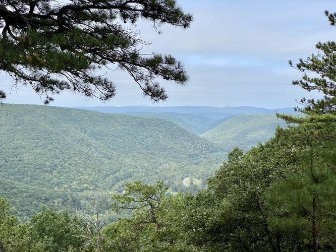
Huckleberry Vista
Around mile 2, hikers will reach the first vista point along this hike - Huckleberry Vista. The vista point boasts views of PA Route 555 and the surrounding mountains. Hikers should take a break here to enjoy the views before heading onward.
Hippo Rock
Just after Huckleberry Vista, around mile 2.1, is a rock that we found and dubbed "Hippo Rock" as this large rock looks like a large hippo with its head jutting out of the ground. The "head" of Hippo Rock can be found furthest away from the trail while the "body" of Hippo Rock is the longer portion jutting toward the trail.
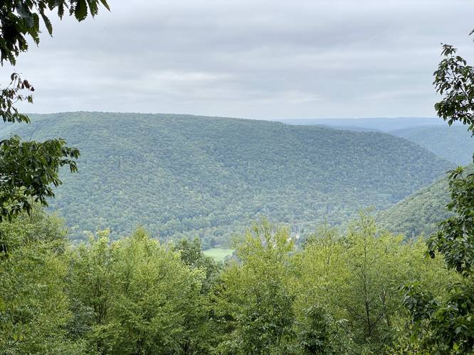
Water Plug Vista
Around mile 2.88, hikers will reach a sign labeled "Rock Trail" and "Main Loop" -- here, hikers should stay on the "Main Loop" to reach Water Plug Vista point just 0.1-miles down the trail. At Water Plug Vista hikers can take in one more view point before heading onward to reach the unique rock formation along the Rock Trail.
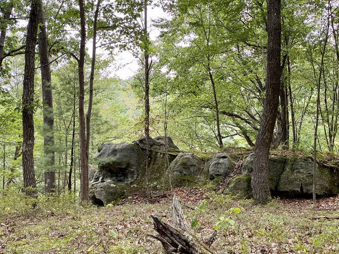
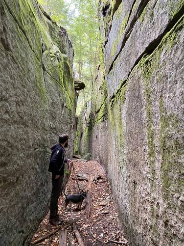
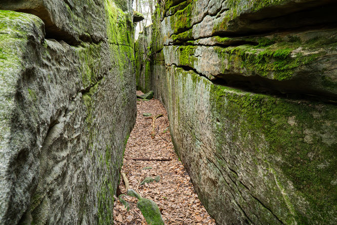
Rock Trail and Rock Formation
After visiting the Water Plug Vista, hikers will continue along the main loop of the Fred Woods Trail before reaching yet another "Rock Trail" sign around mile 3.1. Here, hikers should take a right-hand turn to check out the Rock Trail as it leads into a large 5-foot wide, 20-foot tall, and 100-foot long rock formation. Hikers will walk between these massive rocks while finding inscriptions from past explorers. We were able to find inscriptions from 1901; however, a pair of hikers we ran into mentioned they found inscriptions from the 1800's. This rock formation is unique as it's about 100-feet long as well, giving hikers the chance to take in the scenery. Like many places I've (Admin) written about, like Watkins Glen Gorge and Robert H Treman Gorge, this trail has a hint of some Lord of the Rings to it.
At the far end of the rock formation, the trail will head up and out following yellow blazes. The trail will then wrap around and meet up back at the first "Rock Trail" sign the hiker first passed. Here, hike past Water Plug Vista one more time, and beyond the 2nd "Rock Trail" sign to stay on the main loop.
Hiking Out
After hiking the Rock Trail and passing Water Plug Vista for a 2nd time, the hikers is now headed out and back to parking. The trail will meander through more large rocks before heading back into the forest. Hikers will reach the main loop trail sign before hiking down the single track path that leads to the parking lot.
Difficulty
This trail is rated "moderate" because of the extra-annoying rocky substrate that the main loop follows. Otherwise, this trail can be considered "easy" for the most part, including the elevation change and gain; however some inexperienced hikers may find it more difficult.
Parking
Hikers will find a small parking lot at the coordinates provided. The lot is large enough for about 5 vehicles. Do not block the forest road if the lot is full. Show up early on the weekends to get a good spot.
Directions to the Trailhead
Hikers should note that most GPS systems, including Google Maps, tend to send people down private driveways instead of the proper forest road that leads to this trail. Look for green street signs including one that reads "Fred Woods TRL" to find the proper forest road to drive up.
No Winter Maintenance
The road that leads up to this trail has no winter maintenance.
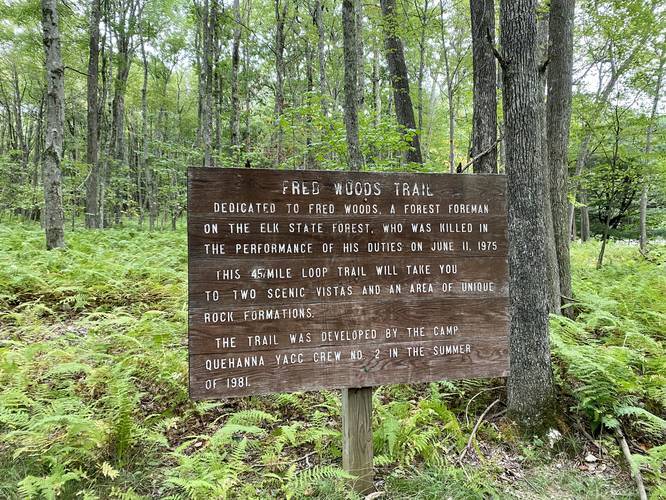
History (transcribed from the sign)
This trail is dedicated to Fred Woods, a forest foreman on the Elk State Forest who was killed in the performance of his duties on June 11, 1975. This loop trail will take you two scenic vistas and an area of unique rock formations. The trail was developed by the camp Quehanna YACC Crew Number 2 in the Summer of 1981.
Trail Names
Fred Woods Trail, Rock Trail.
Trail Description
This hike description and mileage is based on the GPS track provided beginning at the parking lot and then follows the look clockwise.
Hikers will first begin at the trailhead, which includes signage and information for the hiker including a map of named points-of-interest. The entire hike follows yellow blazes. Old orange blazes can still be found along this trail, but that blaze color is outdated for this "foot traffic only" trail.
The trail first follows a single-track path that leads to the main loop. This section of the hike is easy and flat as the trail follows a substrate of mostly dirt. Hikers will find minimal undulation along this section of the hike.
At the main loop, hikers can take a left or right-hand turn; however, this track take a left-hand turn here to follow the trail clockwise. The main loop section of the trail is the "moderate" rated portion as for the next ~3.6 miles, the trail follows a super-annoying rocky path.
After turning at the main loop, the trail does not have much to see until reaching Huckleberry Vista, around mile 2; however, hikers will notice the trail meanders closer to the mountain's edge as it approaches Huckleberry Vista. Additionally, as the vista's name states, hikers will also find a plethora of huckleberry bushes at the top of the mountain, lining the side of the trail.
Huckleberry Vista
Around mile 2, hikers will reach the first vista point along this hike - Huckleberry Vista. The vista point boasts views of PA Route 555 and the surrounding mountains. Hikers should take a break here to enjoy the views before heading onward.
Hippo Rock
Just after Huckleberry Vista, around mile 2.1, is a rock that we found and dubbed "Hippo Rock" as this large rock looks like a large hippo with its head jutting out of the ground. The "head" of Hippo Rock can be found furthest away from the trail while the "body" of Hippo Rock is the longer portion jutting toward the trail.
Water Plug Vista
Around mile 2.88, hikers will reach a sign labeled "Rock Trail" and "Main Loop" -- here, hikers should stay on the "Main Loop" to reach Water Plug Vista point just 0.1-miles down the trail. At Water Plug Vista hikers can take in one more view point before heading onward to reach the unique rock formation along the Rock Trail.
Rock Trail and Rock Formation
After visiting the Water Plug Vista, hikers will continue along the main loop of the Fred Woods Trail before reaching yet another "Rock Trail" sign around mile 3.1. Here, hikers should take a right-hand turn to check out the Rock Trail as it leads into a large 5-foot wide, 20-foot tall, and 100-foot long rock formation. Hikers will walk between these massive rocks while finding inscriptions from past explorers. We were able to find inscriptions from 1901; however, a pair of hikers we ran into mentioned they found inscriptions from the 1800's. This rock formation is unique as it's about 100-feet long as well, giving hikers the chance to take in the scenery. Like many places I've (Admin) written about, like Watkins Glen Gorge and Robert H Treman Gorge, this trail has a hint of some Lord of the Rings to it.
At the far end of the rock formation, the trail will head up and out following yellow blazes. The trail will then wrap around and meet up back at the first "Rock Trail" sign the hiker first passed. Here, hike past Water Plug Vista one more time, and beyond the 2nd "Rock Trail" sign to stay on the main loop.
Hiking Out
After hiking the Rock Trail and passing Water Plug Vista for a 2nd time, the hikers is now headed out and back to parking. The trail will meander through more large rocks before heading back into the forest. Hikers will reach the main loop trail sign before hiking down the single track path that leads to the parking lot.
Difficulty
This trail is rated "moderate" because of the extra-annoying rocky substrate that the main loop follows. Otherwise, this trail can be considered "easy" for the most part, including the elevation change and gain; however some inexperienced hikers may find it more difficult.
Parking
Hikers will find a small parking lot at the coordinates provided. The lot is large enough for about 5 vehicles. Do not block the forest road if the lot is full. Show up early on the weekends to get a good spot.
Directions to the Trailhead
Hikers should note that most GPS systems, including Google Maps, tend to send people down private driveways instead of the proper forest road that leads to this trail. Look for green street signs including one that reads "Fred Woods TRL" to find the proper forest road to drive up.
No Winter Maintenance
The road that leads up to this trail has no winter maintenance.
History (transcribed from the sign)
This trail is dedicated to Fred Woods, a forest foreman on the Elk State Forest who was killed in the performance of his duties on June 11, 1975. This loop trail will take you two scenic vistas and an area of unique rock formations. The trail was developed by the camp Quehanna YACC Crew Number 2 in the Summer of 1981.