The Francis X. Kennedy Trail at Rider Park in Trout Run, Pennsylvania is an easy 1.1-mile loop trail that features a beautiful vista point, Doe Pen Vista.
The trailhead can be found just north of the parking lot and follows green dot blazes in a loop. The trail first follows the forest edge along an open field, where hikers can often find wildflowers growing during the warmer months. There are two picnic tables along this section of the trail as well.
Just as the trail enters the woods, it'll follow a soft pine needle path, passing mountain laurel and evergreens, before reaching the Doe Pen Vista.
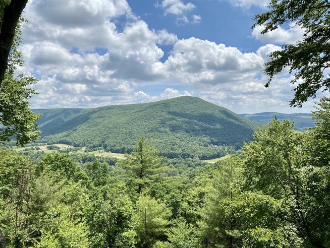
Doe Pen Vista
At the Doe Pen Vista, hikers can enjoy a view of the Loyalsock Creek Gorge to the north. Directly ahead hikers can see the Loyalsock Creek, Allegheny Ridge, and State Route 87.
Continuing onward from the Doe Pen Vista, the trail will lead back into the open field where it loops back around. This section of the hike is well marked until hikers reach an old barn foundation, once owned by the Wheeland Family. The trail is no longer marked near the barn foundation as it meanders its way through the field and back to the trailhead.
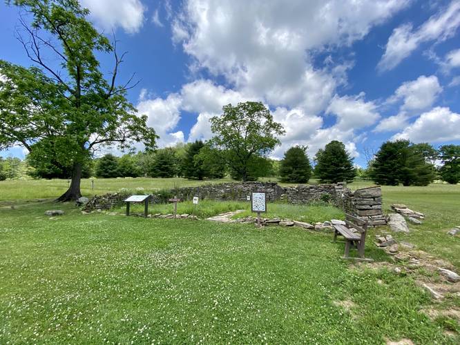
Wheeland Family Homestead
According to literature provided by Rider Park, the Wheeland family owned 24 acres here from 1906 to 1933. Today, all that's left from this homestead are the foundation stones of the Wheeland home, barn, and spring.
Parking
Hikers will find a large parking lot at the coordinates provided - large enough to fit about dozen cars. Just down the road, as you drive in, there will be an equally-sized parking lot about 100-feet away as well.
Facilities
There is a portable-toilet at the trailhead, but there are no running water restrooms available.
Pets
Dogs are allowed if leashed.
Biking
Biking is permitted along this trail and the other trails at Rider Park.
The trailhead can be found just north of the parking lot and follows green dot blazes in a loop. The trail first follows the forest edge along an open field, where hikers can often find wildflowers growing during the warmer months. There are two picnic tables along this section of the trail as well.
Just as the trail enters the woods, it'll follow a soft pine needle path, passing mountain laurel and evergreens, before reaching the Doe Pen Vista.
Doe Pen Vista
At the Doe Pen Vista, hikers can enjoy a view of the Loyalsock Creek Gorge to the north. Directly ahead hikers can see the Loyalsock Creek, Allegheny Ridge, and State Route 87.
Continuing onward from the Doe Pen Vista, the trail will lead back into the open field where it loops back around. This section of the hike is well marked until hikers reach an old barn foundation, once owned by the Wheeland Family. The trail is no longer marked near the barn foundation as it meanders its way through the field and back to the trailhead.
Wheeland Family Homestead
According to literature provided by Rider Park, the Wheeland family owned 24 acres here from 1906 to 1933. Today, all that's left from this homestead are the foundation stones of the Wheeland home, barn, and spring.
Parking
Hikers will find a large parking lot at the coordinates provided - large enough to fit about dozen cars. Just down the road, as you drive in, there will be an equally-sized parking lot about 100-feet away as well.
Facilities
There is a portable-toilet at the trailhead, but there are no running water restrooms available.
Pets
Dogs are allowed if leashed.
Biking
Biking is permitted along this trail and the other trails at Rider Park.