Fourmile Run at Colton Point State Park in Gaines, Pennsylvania is a difficult and dangerous 1.7-mile out-and-back hike that leads down the Turkey Path and up Fourmile Run creek to two large waterfalls - Log Jam Falls and Fourmile Falls (Fourmile Run Falls) - and a smaller waterfall - Rusty Horseshoe Falls. This hike is only for experienced hikers who are used to slippery creek hikes on rocky and, at times, steep terrain.
Hike Description
This hike begins at the main trailhead for Colton Point State Park's Turkey Path and heads downhill along a series of switchbacks, passing Rexford Falls along the way. Remember, inexperienced hikers should not attempt this hike.
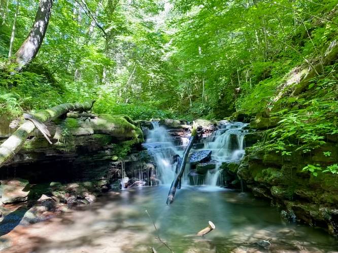
Steep Trail to Log Jam Falls (20-feet tall) - Mile 0.6 to 0.62
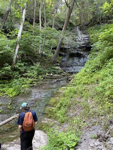
Around mile 0.6, hikers may notice a warn-out hillside with a trail that leads down to Fourmile Run - this is the turn that leads to the top of Log Jam Falls. Log Jam Falls is located around mile 0.62, but note that this waterfall is pretty dangerous in itself due to the steep terrain located adjacent to the ravine that the waterfall cascades into. Log Jam Falls is about 20-feet tall with an eroded hillside that leads down to a rock ledge, perched half-way down the waterfall. Hikers should only appreciated the waterfall from the top of the falls in this area to avoid any accidental fall injuries as the terrain leading down to that rock ledge is far too steep for people to be using safely. The name of Log Jam Falls stems from the history in the area - back in the day, loggers would have "log drives" where they would use splash dams to hold back water on purpose, in order to flood the creeks, which would then send logs floating down to Williamsport to then be milled. This waterfall has the remnants of these old log drives - massive timber can still be found today in the waterfall's ravine. These old trees are covered in moss, which indicates that these dead trees have been sitting in the waterfall for the better part of a century, after the logging industry moved out circa early 1900s.
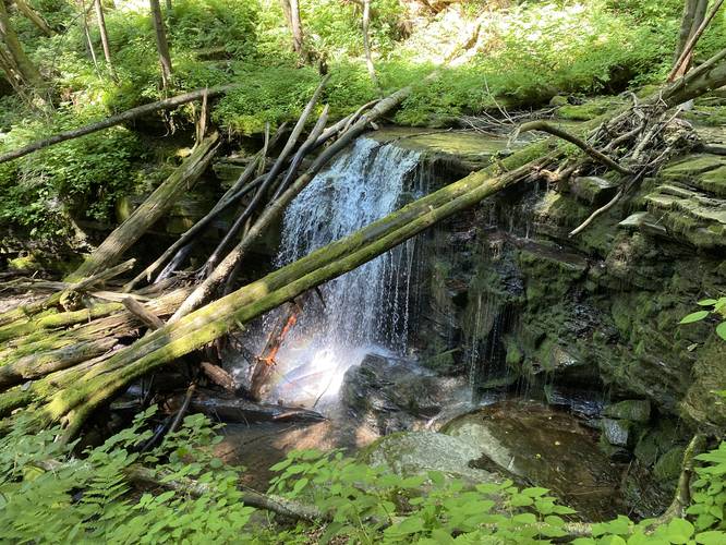
Rusty Horseshoe Falls (8-feet tall) - Mile 0.7
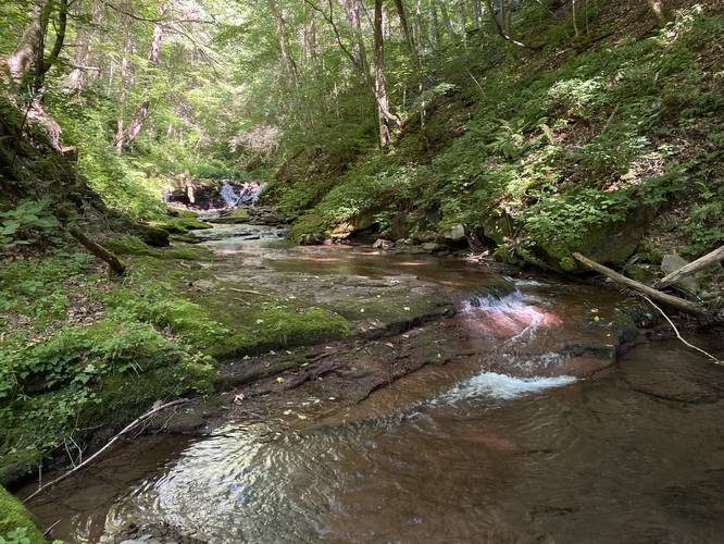
After visiting Log Jam Falls, hikers will make their way up Fourmile Run - passing slippery bedrock and small cascades - sometimes even stinging nettles. Before reaching Rusty Horseshoe Falls, hikers will pass a very small slide waterfall that spills over red bedrock. Hikers will reach Rusty Horseshoe Falls, around mile 0.7. The name of this waterfall comes from its shape and color - the water tints the bedrock a red-ish hue while its physical shape is in the form of a half-circle, hence Rusty Horseshoe Falls. Rusty Horseshoe Falls is not much taller than about 5-feet tall.
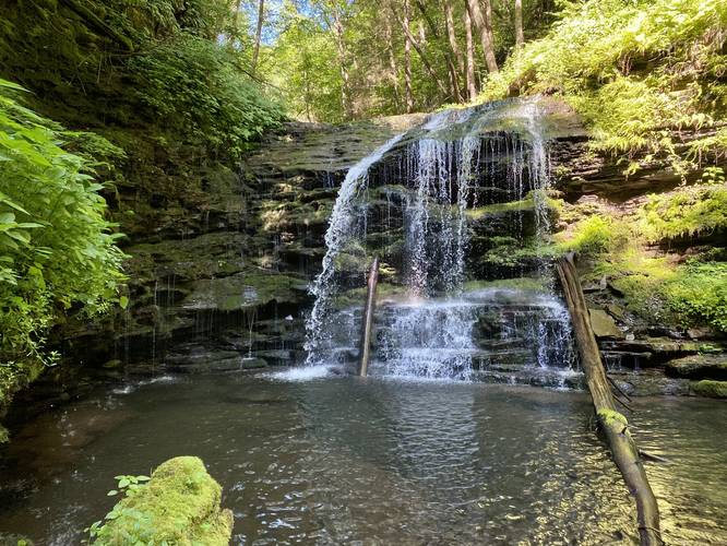
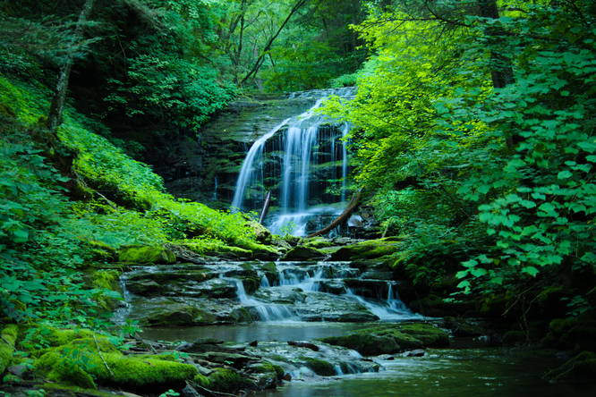
Fourmile Falls (30-feet tall) - Mile 0.85
Finally, after traversing Fourmile Run's slippery creek bed and banks, hikers will reach the ravine for Fourmile Falls. Fourmile Falls is approximately 30-feet tall and cascades into a fairly-large and deep pool. The base of the waterfall is completely inaccessible from the top, unless you're an experienced climber with gear, so this is the only 'hiker-friendly' route to reach the waterfall. Hikers can enjoy the falling water before making their return hike along the same route they took in. Note that hikers will cross into Tioga State Forest around mile 0.75, which means that Fourmile Falls is technically located within Tioga State Forest, not Colton Point State Park.
Hiking Out
While the hike out is opposite to the hike in, it's worth noting a couple of things. When hiking down Fourmile Run, using any moss on the slippery rocks can provide additional friction for your boots. Last, the worst terrain is located just above Log Jam Falls, where the hiker should use the tree roots in the ground to help climb this gnarly section of trail.
Parking
Hikers will find a parking lot at the coordinates provided. It's large enough to fit about a dozen vehicles.
Pets
Dogs should be left at home for this hike for various reasons (unless maybe hunting); however, dogs are technically allowed here.
Warnings
Steep terrain: The Turkey Path at Colton Point State Park is the main trail that hikers will follow before the hike veers off from that trail, down to Fourmile Run, and then up the creek. Turkey Path itself is an extremely-steep and, at times, skinny trail. To reach Fourmile Run, hikers will have to scale and scramble down a very steep connector "trail" that leads to the top of Log Jam Falls and ultimately Fourmile Run from the Turkey Path; however, to do so, hikers must use the roots of trees to safely descend and ascend. Also, it's suggested to not take any shortcuts along the Turkey Path to prevent erosion and any risk of injury.
Slippery creek walk: Once the hiker reaches Fourmile Run, at the top of Log Jam Falls, the hike upstream meanders in and out of the creek - often along slippery rocky creek beds or creek banks. It's best to keep a low profile, if on your butt, or hugging the rock, to avoid any serious falling injuries.
Flash floods and water levels: No one should attempt this hike during the Spring or anytime after a heavy rain. If the creek is running high, there's less room to creek walk and any strong currents in the creek could be a danger to drowning. While not extremely-common in Tioga County, flash floods have washed out roads as recently as the Spring/Summer of 2020/2021 and thus any creek in the area is vulnerable to flash flooding - watch the weather and do not hike any creek if a storm is approaching.
No cell service: With a lack of cell service on this hike, any injuries may take hours if not longer to treat. Take every step with caution and only attempt this hike if you're an experienced hiker on steep terrain and in rocky and slippery creek beds.
Hike Description
This hike begins at the main trailhead for Colton Point State Park's Turkey Path and heads downhill along a series of switchbacks, passing Rexford Falls along the way. Remember, inexperienced hikers should not attempt this hike.
Steep Trail to Log Jam Falls (20-feet tall) - Mile 0.6 to 0.62
Around mile 0.6, hikers may notice a warn-out hillside with a trail that leads down to Fourmile Run - this is the turn that leads to the top of Log Jam Falls. Log Jam Falls is located around mile 0.62, but note that this waterfall is pretty dangerous in itself due to the steep terrain located adjacent to the ravine that the waterfall cascades into. Log Jam Falls is about 20-feet tall with an eroded hillside that leads down to a rock ledge, perched half-way down the waterfall. Hikers should only appreciated the waterfall from the top of the falls in this area to avoid any accidental fall injuries as the terrain leading down to that rock ledge is far too steep for people to be using safely. The name of Log Jam Falls stems from the history in the area - back in the day, loggers would have "log drives" where they would use splash dams to hold back water on purpose, in order to flood the creeks, which would then send logs floating down to Williamsport to then be milled. This waterfall has the remnants of these old log drives - massive timber can still be found today in the waterfall's ravine. These old trees are covered in moss, which indicates that these dead trees have been sitting in the waterfall for the better part of a century, after the logging industry moved out circa early 1900s.
Rusty Horseshoe Falls (8-feet tall) - Mile 0.7
After visiting Log Jam Falls, hikers will make their way up Fourmile Run - passing slippery bedrock and small cascades - sometimes even stinging nettles. Before reaching Rusty Horseshoe Falls, hikers will pass a very small slide waterfall that spills over red bedrock. Hikers will reach Rusty Horseshoe Falls, around mile 0.7. The name of this waterfall comes from its shape and color - the water tints the bedrock a red-ish hue while its physical shape is in the form of a half-circle, hence Rusty Horseshoe Falls. Rusty Horseshoe Falls is not much taller than about 5-feet tall.
Fourmile Falls (30-feet tall) - Mile 0.85
Finally, after traversing Fourmile Run's slippery creek bed and banks, hikers will reach the ravine for Fourmile Falls. Fourmile Falls is approximately 30-feet tall and cascades into a fairly-large and deep pool. The base of the waterfall is completely inaccessible from the top, unless you're an experienced climber with gear, so this is the only 'hiker-friendly' route to reach the waterfall. Hikers can enjoy the falling water before making their return hike along the same route they took in. Note that hikers will cross into Tioga State Forest around mile 0.75, which means that Fourmile Falls is technically located within Tioga State Forest, not Colton Point State Park.
Hiking Out
While the hike out is opposite to the hike in, it's worth noting a couple of things. When hiking down Fourmile Run, using any moss on the slippery rocks can provide additional friction for your boots. Last, the worst terrain is located just above Log Jam Falls, where the hiker should use the tree roots in the ground to help climb this gnarly section of trail.
Parking
Hikers will find a parking lot at the coordinates provided. It's large enough to fit about a dozen vehicles.
Pets
Dogs should be left at home for this hike for various reasons (unless maybe hunting); however, dogs are technically allowed here.
Warnings
Steep terrain: The Turkey Path at Colton Point State Park is the main trail that hikers will follow before the hike veers off from that trail, down to Fourmile Run, and then up the creek. Turkey Path itself is an extremely-steep and, at times, skinny trail. To reach Fourmile Run, hikers will have to scale and scramble down a very steep connector "trail" that leads to the top of Log Jam Falls and ultimately Fourmile Run from the Turkey Path; however, to do so, hikers must use the roots of trees to safely descend and ascend. Also, it's suggested to not take any shortcuts along the Turkey Path to prevent erosion and any risk of injury.
Slippery creek walk: Once the hiker reaches Fourmile Run, at the top of Log Jam Falls, the hike upstream meanders in and out of the creek - often along slippery rocky creek beds or creek banks. It's best to keep a low profile, if on your butt, or hugging the rock, to avoid any serious falling injuries.
Flash floods and water levels: No one should attempt this hike during the Spring or anytime after a heavy rain. If the creek is running high, there's less room to creek walk and any strong currents in the creek could be a danger to drowning. While not extremely-common in Tioga County, flash floods have washed out roads as recently as the Spring/Summer of 2020/2021 and thus any creek in the area is vulnerable to flash flooding - watch the weather and do not hike any creek if a storm is approaching.
No cell service: With a lack of cell service on this hike, any injuries may take hours if not longer to treat. Take every step with caution and only attempt this hike if you're an experienced hiker on steep terrain and in rocky and slippery creek beds.