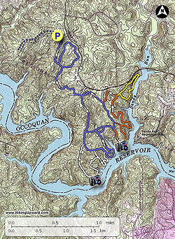
Fountainhead Regional Park, on the banks of the Occoquan Reservoir in
Fairfax County Virginia, has a labyrinth of hiking trails with
surprisingly low usage. The park is broken into 2 areas, a mountain
biking-only set of trails on its western side, and
equestrian/hiking-only trails on the eastern side. The white, orange and
portions of the blue trails near the reservoir are a true walk in the
woods. This area requires going from balze to blaze with no discernable trail in most places.
The hiking/equestrian trails are marked with horseshoe blazes, and posts at most intersections. The white and orange trails offer many panoramic views of the reservoir.
- Mile 0.0 – Start the hike from the parking area on the blue blazed trail. Pass the information box and first blue horseshoe, then follow the trail for 0.37 miles to Intersection #1 (no trail post) at the bottom of a gully.
- Mile 0.37 - Stay right on the blue trail (turning left adds an additional 1.0 mile loop to the hike). After staying right at Intersection #1 continue 100 yards to Intersection #2 (no trail post) at a small stream. Do Not cross the stream, instead turn right downstream on the blue trail. Follow the trail on the right bank of the stream for 0.2 miles where it crosses the stream over a small footbridge. The blue trail will now gradually climb through a small ravine with several switchbacks then arrive at a t-junction and Intersection #3. On this section of the hike you are most likely to see mountain bikers on the opposite side of the ravine on one of the many bike trails.
- Mile 1.05 - At Intersection #3 turn left on the blue blazed trail for 0.07 miles to the 4-way Intersection #4 with the blue blazed service road.
- Mile 1.12 - Turn right on the blue blazed service road as it first passes a clearing, then arrives at Intersection #5 where the blue blazed trail splits again.
- Mile 1.59 - Stay straight on the trail and pass a very muddy section of the road. Stay off the left side of the road, then in 0.16 miles arrive at Intersection #6 and white blazed trail junction.
-
Mile 1.75 - At Intersection #6 turn right on the white horseshoe blazed trail. The trail soon enters the forest as it leaves a service road. Pass over a burn with trees on both sides, then at the top of the rise the trail becomes narrower and heads towards the Occoquan Reservoir. As the reservoir comes into view look 70 yards through the trees to a outcrop and great spot for lunch.
Note: For the next 4 miles on the white, blue, and orange, horseshoe trails the hike is a bushwack following trail markers. For most of this section there is no visable trail. If you don't see the next marker backtrack to the last marker before proceeding.
The white trail will pass through several gullies then arrive at Intersection #7 (no trail post). Turn right on the white trail as it descends to the reservoir before heading back uphill. Pass through another small gully and ascend to Intersection #8 and blue trail where the white trail ends.
- Mile 3.25 - Cross over Intersection #8 staying straight onto the blue trail (turning right will take you on a longer loop along the banks of the reservoir). Continue to follow the blue horseshoes to Intersection #9 (no trail post) where the loop rejoins. Continue along the blue blazed trail until the trail descends to the creek just past the head of the inlet. At this point the blue trail splits at Intersection #10.
- Mile 3.65 - Turn right crossing the creek and follow the blue horseshoes uphill to an old service road and Intersection #11.
- Mile 3.75 - Turn right at Intersection #11 for 0.11 miles where the blue trail turns left, and the orange trail stays straight at Intersection #12 (there is a 1957 Ford Fairlane in 25 yards on the blue trail).
- Mile 3.86 - At Intersection #12 stay straight on the orange trail as it descends back to the reservoir. The trail will loop back towards the park and pass the the red connector trail at Intersection #13 (no post or blazes), then descend towards the reservoir again. Pass another old car, then the trail continues through multiple gullies as it climbs back towards Hampton Rd. Arrive at the Intersection #14 of the yellow blazed loop where the orange loop turns left.
- Mile 5.49 - Turn left on the orange blazed trail at Intersection #14 and follow it to the 4-way Intersection #15 with the blue blazed trail and old service road. The blue blazed trail continues straight and left, with the unblazed service road right that leads to Hampton Road.
- Mile 5.77 - Continue straight at Intersection #14 on the blue blazed trail for 0.28 mils to Intersection #4 with the service road you passed at the beginning of the loop.
- Mile 6.05 - Continue straight for 0.07 miles to Intersection #3 where the blue blazed trail turns right. Do Not be tempted to continue straight as this path leads to the bike only trails section of the park.
- Mile 6.12 - Turn at right at Intersection #3 downhill following the blue trail back to the creek, cross the footbridge, then continue back to Intersection #2 (no post), and turn left and shortly arrive back at Intersection #2
- Mile 6.8 - Stay left uphill for the remaining 0.37 miles back to the park road.
- Mile 7.17 - Arrive back at the parking area and park road