The Fossil Discovery Trail at Dinosaur National Monument near Jensen, Utah is a moderate 1.9-mile out-and-back hike that features petroglyphs and fossilized dinosaur bones.
Hike
This hike begins at the visitors center at the park, where hikers will find signage for the Fossil Discovery Trail located on the north side of the building, after walking-in from the parking lot toward the main building. The trail begins in a wide-open space with no shade and lasts like that for the duration of the hike -- so it's best to refill your water bottles at the visitor center before you head out onto the trail. The first half-mile of the trail is relatively boring to say the least, you'll up hiking through this dry desert along a tall cliff where the terrain is filled with boulders, sand, lizards, and prickly pear cacti -- some of which adorn wildflowers depending on the season.
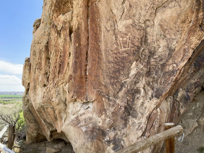
Petroglyphs - Mile 0.5
As the trail winds the corner to head into an anticline valley, hikers will pass a large rock wall with petroglyphs and some pictographs. Please refrain from touching the rock to help preserve these ancient carvings and drawings.
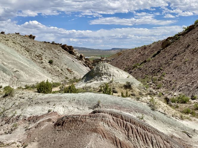
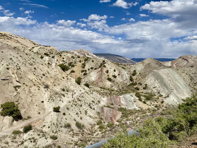
The trail then leads north through the valley where you'll be surrounded by multi-colored slopes of rock and soil that make-up millions of years of geologic changes. On the left-hand side of the trail, around mile 0.6 is an off-shoot trail that leads to the Mowry Shale formation which is easily overlooked -- we honestly skipped that short part of the trail.
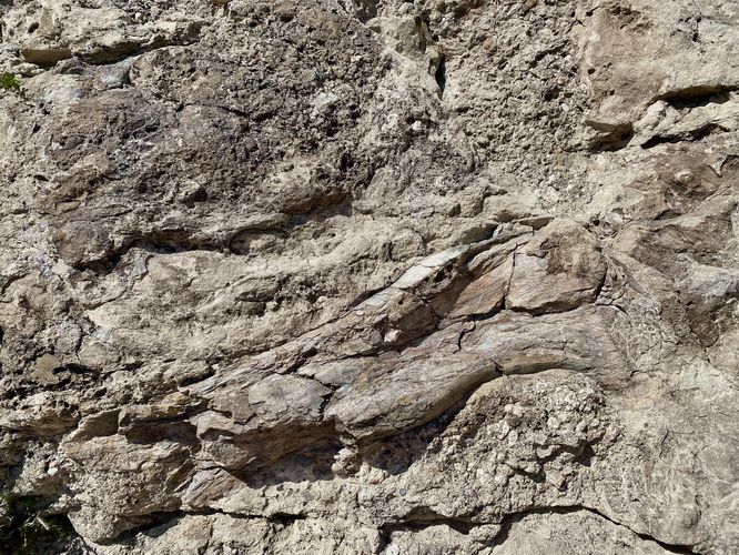
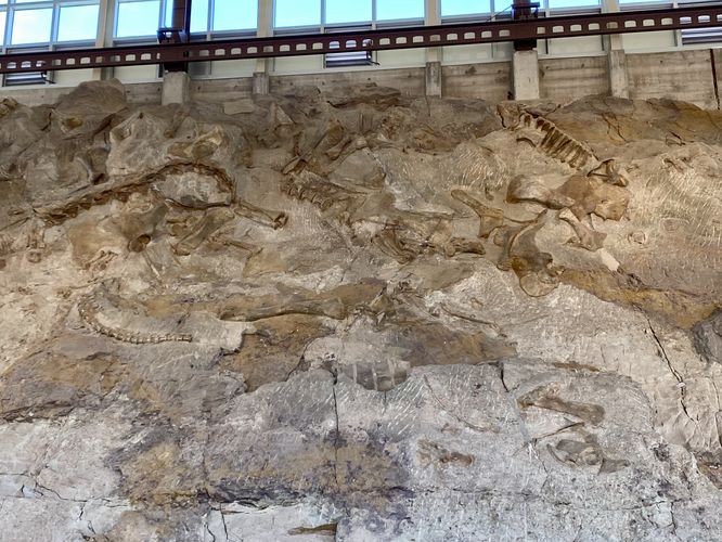
Morrison Formation & Large Dino Femur - Mile 0.75 to 0.8
Around mile 0.75, hikers will reach a short out-and-back spur trail with signage for the "Morrison Formation". This trail leads hikers up along a rocky cliff full of bones ranging from 1/2-inch to 10-inches large, embedded in the rock wall. At the end of the cliff is a very large Sauropod femur bone that's pretty obvious to identify (check the attached photos for more detail). This layer of the Morrison Formation is approximately 151 million years old and follows the same sandstone layer that the Quarry Exhibit Hall has on display; however, this cliff has not been worked on by paleontologists.
After exploring the Morrison Formation, the trail continues northward, passing another optional out-and-back spur to reach the Stump Formation, which is a large fossilized impression of ancient clams. The trail then ascends further to reach its northern terminus located along the road.
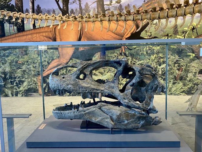
Quarry Exhibit Hall Dinosaur Fossils
The hike isn't over yet -- assuming you hiked-in on this trail, you're going to want to check out the Quarry Exhibit Hall that lies just a few-hundred feet away at the end of the road. The Quarry Exhibit Hall includes 1,500 fossilized dinosaur bones. The exhibit includes the remains of various dinosaur species like the Allosaurus, Apatosaurus, Camarasaurus, Diplodocus, and Stegosaurus. Exhibits, including an 80 foot (24 m) long mural, reveal the story of the many animals that lived in the Morrison environment during the Late Jurassic period. At the end of the exhibit is a large, mostly-intact, Allosaurus skull. The dinosaur bone beds were discovered in 1909 by Earl Douglass, a paleontologist working and collecting for the Carnegie Museum of Natural History. Dinosaur bones were then sent back to the museum and can still be seen on-display today. In 1915, the United States declared the acreage surrounding the quarry a national monument to protect its status. What remains today is the display of over 1,500 fossils that visitors can appreciate, even up close.
Hiking Back - 1.9 to 2.1 miles
If you choose to explore the Quarry Exhibit Hall, the mileage will be closer to 2.1 miles for the hike back to parking. Most of the hike is downhill as it passes back through the valley of fossils. The last 0.5-miles is the slow undulating path that runs along the steep cliffs. You'll wrap up the hike back at the visitors center for a short ~2-mile out-and-back jaunt to see some ancient fossils.
Parking
Hikers will find a very large parking lot at the coordinates provided, located at the Dinosaur National Monument's visitors center on the Utah side of the park. The lot is large enough to fit many dozens of vehicles.
Difficulty
This trail should be considered moderate due to the lack of shade and intense heat along with the uphill sections, despite the short hike length.
Restrooms & Water
The visitors center, at the trailhead has flush toilets and a water refill station for hikers.
Warning
Rattlesnakes: While rare, you may encounter rattlesnakes basking or sunbathing on or near the trail during warm months. If you find any rattlers give them plenty of space.
Hike
This hike begins at the visitors center at the park, where hikers will find signage for the Fossil Discovery Trail located on the north side of the building, after walking-in from the parking lot toward the main building. The trail begins in a wide-open space with no shade and lasts like that for the duration of the hike -- so it's best to refill your water bottles at the visitor center before you head out onto the trail. The first half-mile of the trail is relatively boring to say the least, you'll up hiking through this dry desert along a tall cliff where the terrain is filled with boulders, sand, lizards, and prickly pear cacti -- some of which adorn wildflowers depending on the season.
Petroglyphs - Mile 0.5
As the trail winds the corner to head into an anticline valley, hikers will pass a large rock wall with petroglyphs and some pictographs. Please refrain from touching the rock to help preserve these ancient carvings and drawings.
The trail then leads north through the valley where you'll be surrounded by multi-colored slopes of rock and soil that make-up millions of years of geologic changes. On the left-hand side of the trail, around mile 0.6 is an off-shoot trail that leads to the Mowry Shale formation which is easily overlooked -- we honestly skipped that short part of the trail.
Morrison Formation & Large Dino Femur - Mile 0.75 to 0.8
Around mile 0.75, hikers will reach a short out-and-back spur trail with signage for the "Morrison Formation". This trail leads hikers up along a rocky cliff full of bones ranging from 1/2-inch to 10-inches large, embedded in the rock wall. At the end of the cliff is a very large Sauropod femur bone that's pretty obvious to identify (check the attached photos for more detail). This layer of the Morrison Formation is approximately 151 million years old and follows the same sandstone layer that the Quarry Exhibit Hall has on display; however, this cliff has not been worked on by paleontologists.
After exploring the Morrison Formation, the trail continues northward, passing another optional out-and-back spur to reach the Stump Formation, which is a large fossilized impression of ancient clams. The trail then ascends further to reach its northern terminus located along the road.
Quarry Exhibit Hall Dinosaur Fossils
The hike isn't over yet -- assuming you hiked-in on this trail, you're going to want to check out the Quarry Exhibit Hall that lies just a few-hundred feet away at the end of the road. The Quarry Exhibit Hall includes 1,500 fossilized dinosaur bones. The exhibit includes the remains of various dinosaur species like the Allosaurus, Apatosaurus, Camarasaurus, Diplodocus, and Stegosaurus. Exhibits, including an 80 foot (24 m) long mural, reveal the story of the many animals that lived in the Morrison environment during the Late Jurassic period. At the end of the exhibit is a large, mostly-intact, Allosaurus skull. The dinosaur bone beds were discovered in 1909 by Earl Douglass, a paleontologist working and collecting for the Carnegie Museum of Natural History. Dinosaur bones were then sent back to the museum and can still be seen on-display today. In 1915, the United States declared the acreage surrounding the quarry a national monument to protect its status. What remains today is the display of over 1,500 fossils that visitors can appreciate, even up close.
Hiking Back - 1.9 to 2.1 miles
If you choose to explore the Quarry Exhibit Hall, the mileage will be closer to 2.1 miles for the hike back to parking. Most of the hike is downhill as it passes back through the valley of fossils. The last 0.5-miles is the slow undulating path that runs along the steep cliffs. You'll wrap up the hike back at the visitors center for a short ~2-mile out-and-back jaunt to see some ancient fossils.
Parking
Hikers will find a very large parking lot at the coordinates provided, located at the Dinosaur National Monument's visitors center on the Utah side of the park. The lot is large enough to fit many dozens of vehicles.
Difficulty
This trail should be considered moderate due to the lack of shade and intense heat along with the uphill sections, despite the short hike length.
Restrooms & Water
The visitors center, at the trailhead has flush toilets and a water refill station for hikers.
Warning
Rattlesnakes: While rare, you may encounter rattlesnakes basking or sunbathing on or near the trail during warm months. If you find any rattlers give them plenty of space.