Forty Acre Rock Trail at Forty Acre Rock Heritage Preserve near Kershaw, South Carolina is an easy 1.4-mile out-and-back hike that leads to the top of a massive granitic bedrock outcropping known as Forty Acre Rock.
Hike
This hike begins at the main parking area for the preserve, located at the end of Conservancy Road in Kershaw. Hikers will find a white service road gate at the trailhead. Follow this mostly-flat sandy trail as it passes through a pine forest and leads deeper into the preserve. Hikers won't find much of anything along the trail aside from a sandy substrate and evergreens that fill the forest around you. Eventually, you'll reach some graffiti-covered rocks around mile 0.6. After passing the graffiti rocks, you'll want to be on the lookout for the next trail junction - once you get there, take a left-hand turn. This left-hand turn will send you out onto the middle of the 14-acre large bedrock summit known as Forty Acre Rock.
Forty Acre Rock Summit - Mile 0.65
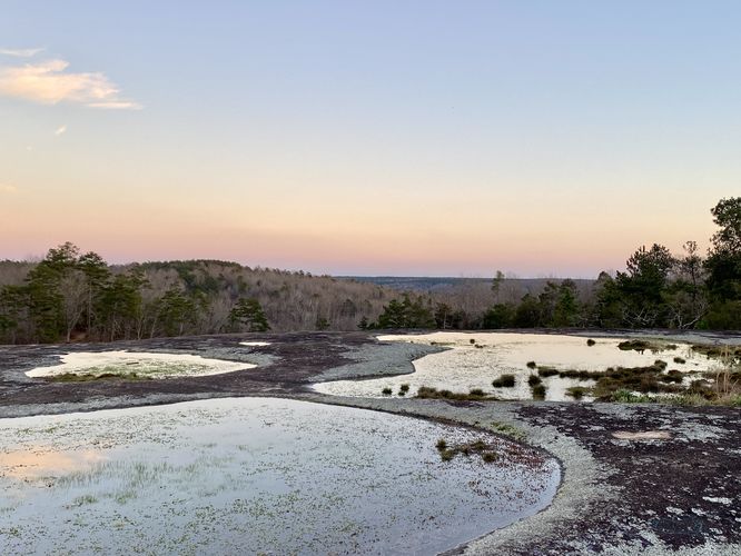
After taking a left-hand turn around mile 0.62, hikers will pass through a scattered forest that dots the massive granitic bedrock outcropping to find the wide open space atop Forty Acre Rock around mile 0.65. From the top of Forty Acre Rock, you can see for quite a while on a clear day; however, most of the views are surrounding and neighboring hills that slope down into the valley below. Forty Acre Rock provides a unique ecosystem as you'll find pools of water sitting in the divots of the bedrock, mosses, lichens, and even succulents growing on the bedrock, and nearby are some shallow root trees, like pines, that survive by clinging to thin soil that lines the edges of the outcropping. During our hike here, we managed to reach Forty Acre Rock at sunset, but were able to spot a nice waterfall in the valley below - located to the east of where we stopped hiking, so there's more to see in the preserve if you wish to hike further.
After exploring the top of Forty Acre Rock, if you do not wish to hike further into the preserve, then the hike out is fairly simple. Most of it is uphill back to parking, but the trail follows a gradual grade. Hikers will reach the parking lot for a ~1.4-mile out-and-back hike.
Parking
Hikers will find a medium-sized parking lot at the coordinates provided, located at the end of Conservancy Road in Kershaw, SC. The lot is large enough to fit just under a dozen vehicles.
Pets
Dogs are allowed only if leashed and must be cleaned up after.
Prohibited
No camping, graffiti, motorized vehicles, or fires. This area is a protected and fragile ecosystem, please keep it that way.
Hours
The preserve is open only during daylight hours.
Hike
This hike begins at the main parking area for the preserve, located at the end of Conservancy Road in Kershaw. Hikers will find a white service road gate at the trailhead. Follow this mostly-flat sandy trail as it passes through a pine forest and leads deeper into the preserve. Hikers won't find much of anything along the trail aside from a sandy substrate and evergreens that fill the forest around you. Eventually, you'll reach some graffiti-covered rocks around mile 0.6. After passing the graffiti rocks, you'll want to be on the lookout for the next trail junction - once you get there, take a left-hand turn. This left-hand turn will send you out onto the middle of the 14-acre large bedrock summit known as Forty Acre Rock.
Forty Acre Rock Summit - Mile 0.65
After taking a left-hand turn around mile 0.62, hikers will pass through a scattered forest that dots the massive granitic bedrock outcropping to find the wide open space atop Forty Acre Rock around mile 0.65. From the top of Forty Acre Rock, you can see for quite a while on a clear day; however, most of the views are surrounding and neighboring hills that slope down into the valley below. Forty Acre Rock provides a unique ecosystem as you'll find pools of water sitting in the divots of the bedrock, mosses, lichens, and even succulents growing on the bedrock, and nearby are some shallow root trees, like pines, that survive by clinging to thin soil that lines the edges of the outcropping. During our hike here, we managed to reach Forty Acre Rock at sunset, but were able to spot a nice waterfall in the valley below - located to the east of where we stopped hiking, so there's more to see in the preserve if you wish to hike further.
After exploring the top of Forty Acre Rock, if you do not wish to hike further into the preserve, then the hike out is fairly simple. Most of it is uphill back to parking, but the trail follows a gradual grade. Hikers will reach the parking lot for a ~1.4-mile out-and-back hike.
Parking
Hikers will find a medium-sized parking lot at the coordinates provided, located at the end of Conservancy Road in Kershaw, SC. The lot is large enough to fit just under a dozen vehicles.
Pets
Dogs are allowed only if leashed and must be cleaned up after.
Prohibited
No camping, graffiti, motorized vehicles, or fires. This area is a protected and fragile ecosystem, please keep it that way.
Hours
The preserve is open only during daylight hours.