Loading...

🎉 Enjoy a Free 7-Day Supporter Trial and Unlock Exclusive Perks — No Credit Card Required. Learn more.

Fort Point State Park Hike

Directions
Map
Pictures
Send to App
Distance:
0.8 Miles / 1.3 km
Type:
Loop
Difficulty:
Easy
Time to Hike:
~24 minutes
Features:
Surface Type:
Dirt
Park:
Fort Point State Park
Town:
Stockton Springs, Maine
Directions:
44.468677, -68.811739
Added:
May 15, 2025
Updated:
May 21, 2025
Copy Trail Link Hiking this trail? Send a friend or family member a link to this trail guide for your own safety. Hike at your own risk (disclaimer)
Loading...
Loading...
77'

Total Change
84'

Ascent
91'

Descent

Download the Trail Route for Offline Use

Supporters get exclusive access to download trail routes to the MyHikes app for offline use. Stay prepared on your adventure, even without an internet connection! Become a Supporter today to unlock this feature and hike with confidence.

Send to App

Fort Point State Park Hike

The Fort Point State Park Hike at Fort Point State Park in Stockton Springs, Maine is an easy 0.8-mile loop that features views of Cadillac Mountain, the Penobscot River, and leads to the scenic Fort Point Light and Bell Tower.

Exploring Fort Point State Park

If you're looking for a quiet waterfront to explore with few-very people, Fort Point State Park is a great place along Maine's coastline that features views, a historical lighthouse, and an old war fort from the 1700s. Oh, and I mention it's pretty quiet here?

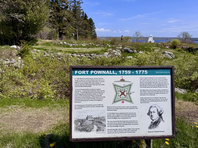
This track leads around the majority of the state park's trails and open grass pathways. Starting at the parking lot, this route heads south to reach the remnants of Fort Powell (1759 - 1779) which once stood on this site. The old fort is long-gone, but it's ramparts remain with short but steep slopes that used to define fort walls and boundaries. You can explore the old fort remnants between miles 0.05 and 0.1.

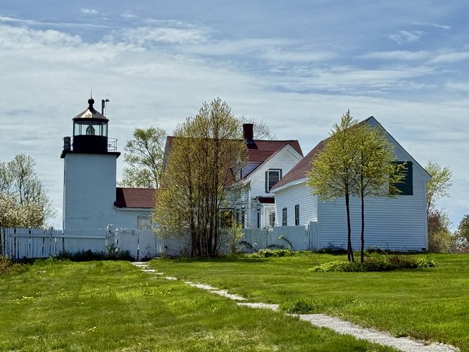
Fort Point Light - Mile 0.22

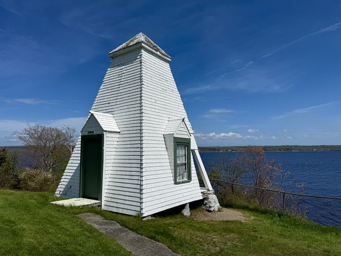
After exploring the old ramparts of Fort Powell, the route leads north toward the parking lot to connect with the main trail system. Follow the trail out toward the Penobscot River where you'll find nice views of the water and the scenic Fort Point lighthouse, known as Fort Point Light. Sitting to the side of the lighthouse is the Fog Bell Tower that was used to alert ships passing through the river to avoid the point. On the river side of the tower, you'll find the old bell and in the window of the tower you'll find historical information and a drawing of how the bell system worked.

Views of Cadillac Mountain - Mile 0.37

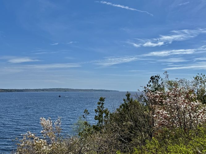
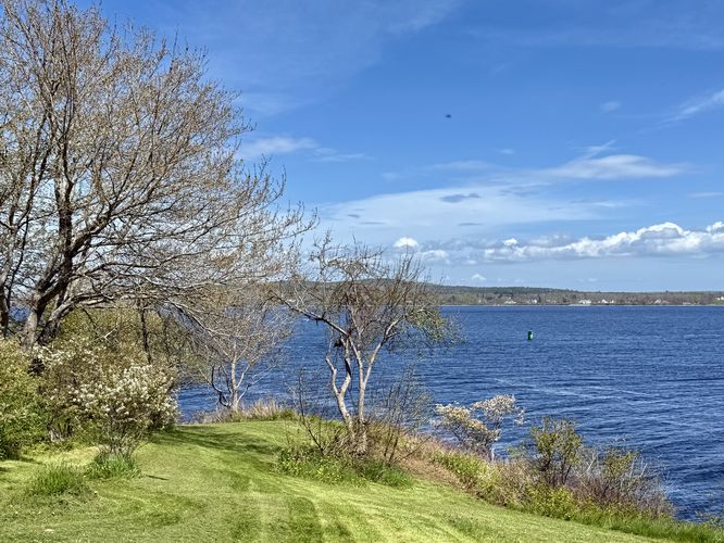
The next stop along this short hike leads from the Fog Bell Tower north to the shores of Fort Point where you'll find a rocky coastline and distant views of Cadillac Mountain. You can also opt to sit along the less-rocky beach that can be found here. No swimming is allowed, however, due to strong currents.

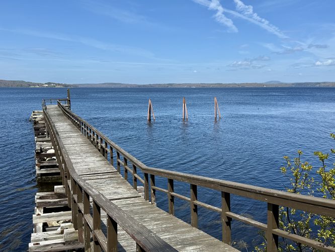
Views & Dock - Mile 0.6

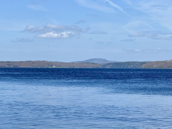
The last scenic stop along this hike leads west from the rocky beach to a dock / wharf that juts out from Fort Point into the Penobscot River. At mile 0.6, you'll find the dock, which was closed in May 2025 for repairs. At the dock, you'll find more water views and distant views of Cadillac Mountain.

Hike to Parking - Mile 0.6 to 0.8

The last leg of this short hike leads from the dock, through the official trail system, to reach the parking lot. Follow the road of the parking lot around the loop to return back to your vehicle to complete the 0.8-mile loop.

Parking & Fees

There's a small $4/vehicle out-of-state fee or $3/vehicle in-state fee for visitors which can be paid when entering the park. Visitors will find many parking spaces along the loop drive in the park near the coordinates provided. The lot is large enough to fit about 20 vehicles, max, as of May 2025.

Pets

Dogs are allowed only if leashed and cleaned up after.
Explore 14 trails near Stockton Springs, ME
  1. Parking

    44.468677, -68.811739
  2. Main Trailhead

    44.468677, -68.811739
  3. Fort Powell (1759 - 1775)

    44.468125, -68.811997
    Fort Powell (1759 - 1775)
  4. Fog Bell Tower at Fort Point

    44.467544, -68.811006
    Fog Bell Tower at Fort Point
  5. View of the Penobscot River from Fort Point State Park

    44.467342, -68.811211
    View of the Penobscot River from Fort Point State Park
  6. Fort Point Light (private)

    44.467289, -68.811408
    Fort Point Light (private)
  7. View of the Penobscot River

    44.467919, -68.810508
    View of the Penobscot River
  8. View of Cadillac Mountain in the distance

    44.468931, -68.809761
    View of Cadillac Mountain in the distance
  9. View from the dock (closed May 2025)

    44.470558, -68.813156
    View from the dock (closed May 2025)
No community routes found. To add your own hike as a Community Route for this Trail guide, leave a Trip Report with an attached GPX file.

Hazards

Ticks - Lyme Disease More Info (CDC)
Poison Ivy/Oak

Seasons

All

Weather Forecast

In Stockton Springs, ME

Explore Hiking Trails

You May Also Like

Colorado's Million Dollar Highway - Plan a day's drive adventure along the iconic Million Dollar Highway in Colorado. Explore the best short trails, roadside stops, waterfalls, vistas, ghost towns, and hot springs within a ~6 hour road trip.
Explore

Colorado's Million Dollar Highway

Plan a day's drive adventure along the iconic Million Dollar Highway in Colorado. Explore the best short trails, roadside stops, waterfalls, vistas, ghost towns, and hot springs within a ~6 hour road trip.

Read
Glacier's Going-to-the-Sun Road - Discover the breathtaking beauty of Glacier National Park along the iconic Going-to-the-Sun Road. From stunning roadside stops to picturesque waterfalls and vistas, this engineering marvel offers endless opportunities for exploration.
Explore

Glacier's Going-to-the-Sun Road

Discover the breathtaking beauty of Glacier National Park along the iconic Going-to-the-Sun Road. From stunning roadside stops to picturesque waterfalls and vistas, this engineering marvel offers endless opportunities for exploration.

Read
New York's Best Waterfalls - Whether you're planning a day hike, roadside stop, or a leisurely short walk, this guide provides hikers, travelers, and locals alike with 63 different locations to over 100 scenic waterfalls to help plan your next adventure!
Explore

New York's Best Waterfalls

Whether you're planning a day hike, roadside stop, or a leisurely short walk, this guide provides hikers, travelers, and locals alike with 63 different locations to over 100 scenic waterfalls to help plan your next adventure!

Read

Before you boogie...

Find our trail guides useful? Consider becoming a Supporter to unlock perks!

MyHikes is an indie platform that makes exploring public trails easier for everyone. The platform has no investors, no ads, and is owned and operated by one person, Dave Miller. Dave has personally mapped and written over 1,800 trail guides on MyHikes for the public to explore. MyHikes has helped millions outdoor enthusiasts plan their next adventure.

But it takes a lot of time 🕦, money 💰, work, and espresso shots ☕ to run MyHikes, including hiking , mapping , writing , and publishing new trails with high-quality (accurate) information... along with software engineering (coding) the platform like building new features, website and mobile app development (iOS and Android), site maintainance . and much much more.

Supporters unlock website and mobile app perks with an annual one-time payment of $25 (you renew) 😎👍. Or you can simply make a Donation of your choice. Otherwise, you can support us by telling your friends about MyHikes - both quick and free 🎉

Admin user profile picture

Dave Miller
MyHikes Founder