The Fort McClary Trail at Fort McClary State Historic Site in Kittery, Maine is an easy 0.3-mile loop trail that leads to the Fort McClary Blockhouse, old fort walls and ramparts, a caponier tunnel, and features scenic views of Pepperrell Cove.
Walking around Fort McClary
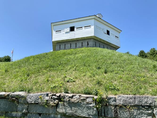
The trail at Fort McClary begins at the eastern end of the main parking lot. Visitors will find a paved path at the trailhead where this route follows the trail around the bend as it runs below Fort McClary's Blockhouse. This route then leads west to reach the caponier, which is a fortified tunnel dug into the hillside. The caponier is one of the most-interesting old military structures at the park. Visitors will walk down a series of stairs to reach a dank and creepy tunnel that lead to views of Portsmouth Harbor and Portsmouth Harbor Light located directly across the water. The route then leads north, hopping off of the paved path to reach old ramparts and walls of the fort. It then leads back south after reaching a dead end to head back toward the main trailhead. At the trailhead, the path leads uphill to reach the Fort McClary Blockhouse, a Rifleman's House, and an old Powder House (magazine) -- all built around 1808. Visitors can head into the Blockhouse to explore a couple different levels of the old military structure where you'll find more historical information, views of Pepperrell Cove, and more. Once done, the trail leads back to parking for a short 0.4-mile loop walk.
Parking
Visitors will find a large parking lot at the coordinates provided (43.08221, -70.709235) located on the south side of Pepperrell Road in Kittery, Maine. The lot is large enough to fit over a dozen vehicles as of July 2023.
Pets
Dogs are allowed only if leashed and must be cleaned up after.
Fees
As of July 2023, there's a self-serve donation station where visitors should pay the suggested fee of $4/adult for non-residents, $3/adult for Maine residents.
Walking around Fort McClary
The trail at Fort McClary begins at the eastern end of the main parking lot. Visitors will find a paved path at the trailhead where this route follows the trail around the bend as it runs below Fort McClary's Blockhouse. This route then leads west to reach the caponier, which is a fortified tunnel dug into the hillside. The caponier is one of the most-interesting old military structures at the park. Visitors will walk down a series of stairs to reach a dank and creepy tunnel that lead to views of Portsmouth Harbor and Portsmouth Harbor Light located directly across the water. The route then leads north, hopping off of the paved path to reach old ramparts and walls of the fort. It then leads back south after reaching a dead end to head back toward the main trailhead. At the trailhead, the path leads uphill to reach the Fort McClary Blockhouse, a Rifleman's House, and an old Powder House (magazine) -- all built around 1808. Visitors can head into the Blockhouse to explore a couple different levels of the old military structure where you'll find more historical information, views of Pepperrell Cove, and more. Once done, the trail leads back to parking for a short 0.4-mile loop walk.
Parking
Visitors will find a large parking lot at the coordinates provided (43.08221, -70.709235) located on the south side of Pepperrell Road in Kittery, Maine. The lot is large enough to fit over a dozen vehicles as of July 2023.
Pets
Dogs are allowed only if leashed and must be cleaned up after.
Fees
As of July 2023, there's a self-serve donation station where visitors should pay the suggested fee of $4/adult for non-residents, $3/adult for Maine residents.