Loading...

❄️ WINTER SALE! 50% OFF on Supporter Accounts — now through January 31st. Unlock a full year of exclusive website & app perks. Learn More.

Forks of Red Creek Hike

Arguably one of the most unique, and beautiful hiking areas on the East Coast. The high plateaus of Dolly Sods are made up of wind carved sand stone, stunted red spruce, grassy meadows, and sphagnum bogs. The characteristic meadows are the result of logging that took place from 1899 to 1924. During the Second World War the U.S. Army used the area for artillery and mortar training, and at the trailheads the Army Corp of Engineers still displays signs warning hikers that there may be unexploded ordinance in the area.

The name Dolly Sods derives from a combination of Dahles, a local 18th century family, and Sods, meaning an open mountain top or meadow. After WWII the area fell into neglect, and was threatened by multiple construction and mining project proposals. Then in the early 1970’s concerned environmentalists, along with The Nature Conservancy, began purchasing the land for preservation and recreational use. Today the Dolly Sods Wilderness Area comprises 17,371 acres.

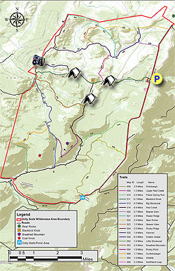
  • Mile 0.0 - From the parking area, just past the Red Creek Campground, start the hike on the wooden walkway at the beginning of the Blackbird Knob Trail TR511, and shortly enter a wooded area thick with spruce. In 0.3 miles leave the wooded area and get your first glimpse of the majestic plains in Dolly Sods. Continue down to the first creek crossing in 0.7 miles. After crossing the creek, it will be another 0.7 miles to Red Creek. Pass a side crossing to a small island, and in 50 yards arrive at the Red Creek crossing.
  • Mile 1.7 - Cross Red Creek. Note that Red Creek can run high and require fording instead of rock hopping, so make sure to bring river shoes. After crossing Red Creek there are several camping sites on the right. Climb through a small gully then enter the first of many meadows and reach the intersection of the Upper Red Creek Trail TR509.
  • Mile 1.9 - Stay straight on the Blackbird Knob Trail TR511 passing through a wooded area, then arriving at the intersection of the Red Creek Trail TR514 on the left in another 0.4 miles.
  • Mile 2.3 Continue straight on the Blackbird Knob Trail TR511 through another meadow, crossing a stream, then climb to the intersection of the Harman Trail TR525.
  • Mile 3.2 - Stay left continuing on the Blackbird Knob Trail TR511 for another 1.2 miles then veer left, and in 0.1 miles reach the terminus of the Rocky Ridge Trail TR524.
  • Mile 4.5 - Stay on the Blackbird Knob Trail TR511 continuing downward for 0.2 miles to the 4 way intersection of the Breathed Mountain Trail TR553, Big Stonecoal Trail TR513, and Forestry Road that leads down to Canaan Valley.
  • Mile 4.7 - Turn left on the Breathed Mountain Trail TR553 and pass through a wooded area before the trail becomes boggy, passes through a meadow, then descends steeply to the Red Creek Trail TR514 in 2.6 miles.
  • Mile 7.3 - Turn left on the Red Creek Trail TR514 and arrive at the Forks of Red Creek in 0.1 miles. There are numerous campsites at ‘The Forks’ but note that this area is an extremely popular camping area, especially with the college set. Explore many small waterfalls and swimming holes.
  • Mile 7.4 - Cross the Left Fork of Red Creek and stay to your left as the Red Creek Trail TR514 passes through a camping area then re-enters the woods on the left. From this point the Red Creek Trail TR514 becomes steeper until it enters the first of two large meadows. After passing through the second meadow the trail re-enters the woods and ends at the intersection of the Blackbird Knob Trail TR511.
  • Mile 8.3 - Turn right on the Blackbird Knob Trail TR511 retracing your route, passing the Upper Red Creek Trail TR509, re-crossing Red Creek, then hiking the back to FR75 and the parking area.
  • Mile 10.0 - Arrive back at FR75 and the parking area.
Explore 46 trails near Dolly Sods Wilderness, WV

Know Before You Go

  • The Forks of Red Creek Hike in Dolly Sods Wilderness is a 10-mile loop offering unique landscapes, including meadows, bogs, and historical remnants of logging and military training.
  • Hikers should be prepared for potential high water levels at Red Creek, requiring fording, and be aware of possible unexploded ordinance in the area.
  • The area's preservation is due to conservation efforts in the 1970s, and the Forks of Red Creek is a popular camping destination with waterfalls and swimming holes.
Interactive topographic map for Forks of Red Creek Hike located in Dolly Sods Wilderness, WV. Click the "View Map" button to load GPS coordinates and trail markers.
Get directions
Distance
10.0 mi
Difficulty
Moderate
Type
Loop
Est. Time
5 hrs
Elev. Gain
1,397'
Rating
4.0
Added
March 16, 2025
Updated
April 05, 2025

Weather Forecast

Today
High 43°F
Partly Sunny
Tonight
Low 35°F
Partly Cloudy
Wednesday
High 37°F
Chance Rain And Snow
Wednesday Night
Low 10°F
Light Snow
Thursday
High 13°F
Chance Light Snow then Scattered Snow Showers
Thursday Night
Low 7°F
Isolated Snow Showers then Mostly Clear
Friday
High 26°F
Chance Light Snow
Friday Night
Low 21°F
Chance Light Snow
Saturday
High 28°F
Light Snow Likely
Saturday Night
Low 12°F
Chance Light Snow
Sunday
High 19°F
Chance Light Snow
Sunday Night
Low 7°F
Slight Chance Light Snow
M.L. King Jr. Day
High 19°F
Slight Chance Light Snow
Monday Night
Low 7°F
Partly Cloudy
Loading...
Total Change
581'
Ascent
1,397'
Descent
1,397'
Loading...

Download the GPX Data for Offline Use

Supporters get exclusive access to download trail routes to the MyHikes app for offline use. Stay prepared on your adventure, even without an internet connection! Become a Supporter today to unlock this feature and hike with confidence.

Download Forks of Red Creek Hike GPX Data to the MyHikes Mobile App

Features

Vista / Lookout Point
Dogs
Waterfalls
Camping
Water Source

Points of interest

  1. Parking

    39.03348, -79.31424
  2. Main Trailhead

    39.03348, -79.31424

Safety information

For your own safety: plan ahead, let someone know where you'll be, and hike at your own risk.

Hazards

Snakes (Rattlesnakes, Copperheads, others)
Poison Ivy or Poison Oak

Availability

All seasons

Surface type

Dirt

Trip Reports (Reviews)

Rated 4.0 out of 5 based on 9 ratings.

Ready to help fellow hikers? Add a trip report to share your experience and provide valuable insights for other hikers!

By: Rich
10.0 miles / 16.1 km
September 23, 2016
A really tough experience for me. The trail is not marked at all and is very very difficult to follow. I lost the trail 4 times in the first 2 miles. Finally as I started to run out of daylight, I made the miserable decision to turn around and head for the car. The trail is extremely narrow but quite clear for the first .5 miles. Then, as it nears the spruce stands, there is no undergrowth to border the trail which makes things very difficult without markings or blazes. Even when the trail is well defined, its unpleasantly narrow. I would suggest pants, a companion, and a really good GPS device which I did not have with me. My apologies to aldikuma. I read their prior review and assumed they did not have much experience. I am no the most experienced but have definitely logged a couple hundred miles each year for the last few years. Generally I can keep to a trail but this one was unpleasantly challenging and eventually won out over me! Big bummer.
Legacy Review
By: Adam and Grace
10.0 miles / 16.1 km
June 13, 2015
This hike provided some of the most unique scenery we have seen while hiking on the East Coast. We caught the Mountain Laurel in full bloom, so the hillsides were covered in pink. Red creek is dynamic and beautiful. Camping spots are plentiful and if you search you can find some that are isolated. We hiked through some showers and the trails were full of muddy, boggy areas, which kept hiking in those spots to a pace of about 2 miles per hour. In other spots the trail is a streambed, which also makes finding a footpath a slower process. Foot traffic was moderate- we crossed many other hikers during our trip and there were about 10 other tents set up by Red Creek. The parking area was full so we parked along the road (they ask you not to park in the adjacent campsite). Overall, a worthwhile experience and we plan on returning soon to hike other trails in the area.
Legacy Review
By: Hans ( und Heidi )
10.0 miles / 16.1 km
October 03, 2014
We hiked the Dolly Sods North the day before. The timing for fall colors was almost perfect, but late by a week. See the review for that hike. This Hike is our least favorite in the Dolly Sods. The hike up the Red Creek from the Laneville Hamlet is of different character , with the steep valleys of rhododendron forest and Maine like mossy - ness. do that instead of the central Sods,( as a day hike) After 6 trips here, this is what we think of this unique place . Camp sites are plentiful, and very nice ones . These are found everywhere . Best Place ever for campsites ! In the Spring, Either the rhododendrons or the Mountain Laurel will be in bloom. Rhodos are in the South Sods, Laurels in the North. Laurels bloom earlier than the Rhodos. The abundance is beyond belief. In the Fall, if you time it right, the North is a sight unlike anywhere in the world. Earlier is better. We think last of September, but watch the weather there on the internets, Be prepared for wind, Colder than you expect, like the steppes. The trees grow sideway here , like Patagonia ! H und H
Legacy Review
No community routes found. To add your own hike as a Community Route for this Trail guide, leave a Trip Report with an attached GPX file.

Popular categories

Scenic mountain view representing vista trails
Vista trails
Scenic gorge of cascades representing waterfall trails
Waterfall hikes
Rugged mountain terrain representing summit trails
Summit trails
Scenic mountain view representing dog-friendly trails
Dog-friendly
Scenic campsite with a view representing camping trails
Camping trails
Appalachian Trail logo representing A.T. hikes
A.T. hikes

You May Also Like

Colorado's Million Dollar Highway - Plan a day's drive adventure along the iconic Million Dollar Highway in Colorado. Explore the best short trails, roadside stops, waterfalls, vistas, ghost towns, and hot springs within a ~6 hour road trip.
Explore

Colorado's Million Dollar Highway

Plan a day's drive adventure along the iconic Million Dollar Highway in Colorado. Explore the best short trails, roadside stops, waterfalls, vistas, ghost towns, and hot springs within a ~6 hour road trip.

Read
🍪 We use cookies to learn about site usage and to serve map tiles. You may block cookies manually in the browser. By continuing you agree. Learn more