The Flaming Geyser and Bubbling Geyser hike at Flaming Geyser State Park near Black Diamond, Washington is an easy 0.6-mile hike that leads to two natural oddities caused by coal drilling in the early 1900's.
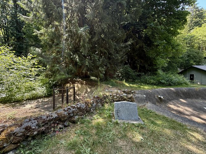
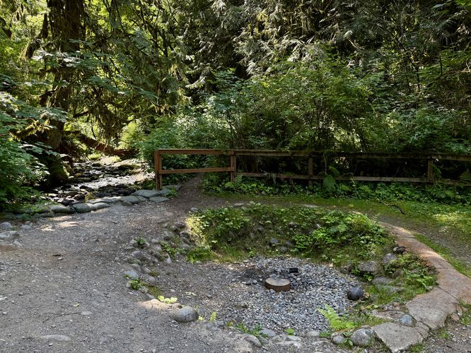
After passing the trailhead entrance, the first stop along the hike are the Salmon Ponds, located near mile 0.05. During our visit here, the ponds were completely void of water and thus void of Salmon. Just further up the trail sits the Flaming Geyser, around mile 0.08, located just off of the south side of the main trail. Follow the signs to locate it. When you arrive, you may be curious why it's called the Flaming Geyser as the geyser is likely not flaming, lit, or on fire. Visitors will find a circular fire pit with what appears to be a pipe sticking out of the ground. This is the Flaming Geyser. The Flaming Geyser is an old bore hole that was drilled in 1911 by a coal mining company. During the drilling, around 900-feet deep, the hole started spewing methane gas and bubbling saltwater. After revisiting the site 1-week later, the coal miners lit the bore hole on fire and watched the flames dance between 5-inches and 3-feet tall, sometimes reaching 15-feet in height. Over time, the bore hole has expelled most of the methane gas. It's unclear how often the Flaming Geyser is relit, or if it's still legal to do so.
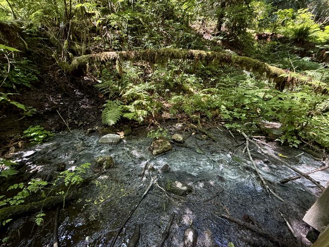
If you're disappointed by the lack of flames at the Flaming Geyser, you might want to check out one more natural oddity along the hike, the Bubbling Geyser. Be warned, the Bubbling Geyser is not what you think it is, but if you plan to explore further, you certainly can! Hike eastward and cross the footbridge that spans Cristy Creek. Take a right-hand turn at the sign for the Bubbling Geyser. This trail leads through a lush forest full of moss-covered trees and some old-growth. Following the trail all the way to the end leads to a small platform above Cristy Creek where you'll find historical and natural information about the Bubbling Geyser. On the south side of the platform sits the Bubbline Geyser with its methane bubbles and calcium spewing from underground. The waters here are full of ghost-like white strands of vegetation. These white strands of vegetation are caused by the increased levels of calcium in the water.
After exploring the Bubbling Geyser, the hike back to parking is quick and easy as it's mostly all downhill. Take the trail back to parking for a short and easy 0.6-mile walk.
This Calcium Carbonate settles out of the water and creates the grey residue you see in front of you. This process is very similar to what you might see at Yellowstone National Park, the only dirterence being that water coming out of the Bubbling Geyser is not heated to high temperatures by geothermal heat, meaning there are less algae and bacteria to create the vibrant colors that are associated with Yellowstone National Park geysers."
Explore the Flaming & Bubbling Geysers
This short hike begins at the very end of SE Flaming Geyser Road at the state park where visitors will find a small parking turnout at the coordinates provided. The trailhead starts at the service road gate, located just east of the parking area.After passing the trailhead entrance, the first stop along the hike are the Salmon Ponds, located near mile 0.05. During our visit here, the ponds were completely void of water and thus void of Salmon. Just further up the trail sits the Flaming Geyser, around mile 0.08, located just off of the south side of the main trail. Follow the signs to locate it. When you arrive, you may be curious why it's called the Flaming Geyser as the geyser is likely not flaming, lit, or on fire. Visitors will find a circular fire pit with what appears to be a pipe sticking out of the ground. This is the Flaming Geyser. The Flaming Geyser is an old bore hole that was drilled in 1911 by a coal mining company. During the drilling, around 900-feet deep, the hole started spewing methane gas and bubbling saltwater. After revisiting the site 1-week later, the coal miners lit the bore hole on fire and watched the flames dance between 5-inches and 3-feet tall, sometimes reaching 15-feet in height. Over time, the bore hole has expelled most of the methane gas. It's unclear how often the Flaming Geyser is relit, or if it's still legal to do so.
If you're disappointed by the lack of flames at the Flaming Geyser, you might want to check out one more natural oddity along the hike, the Bubbling Geyser. Be warned, the Bubbling Geyser is not what you think it is, but if you plan to explore further, you certainly can! Hike eastward and cross the footbridge that spans Cristy Creek. Take a right-hand turn at the sign for the Bubbling Geyser. This trail leads through a lush forest full of moss-covered trees and some old-growth. Following the trail all the way to the end leads to a small platform above Cristy Creek where you'll find historical and natural information about the Bubbling Geyser. On the south side of the platform sits the Bubbline Geyser with its methane bubbles and calcium spewing from underground. The waters here are full of ghost-like white strands of vegetation. These white strands of vegetation are caused by the increased levels of calcium in the water.
After exploring the Bubbling Geyser, the hike back to parking is quick and easy as it's mostly all downhill. Take the trail back to parking for a short and easy 0.6-mile walk.
History of the Flaming Geyser
From the Flaming Geyser State Park website: "On October 4, 1911, coal miner Eugene Lawson drilled a test bore in today’s park area, attempting to locate a coal seam. At 390 feet deep, he found a seam 6.5 feet thick. Methane gas began releasing out of the hole as the drill depth passed 900 feet, on its way to a final depth of 1,403 feet. Returning to the drilled hole a week later, Lawson observed gas and saltwater “bubbling furiously” out of the hole. He ignited the gas and it burned, with a flame from 5 inches to three feet in height, occasionally leaping up to fifteen feet. The methane seep has depleted over time, and the flame sometimes blows out. It is usually easily relit, though, and serves as a reminder of the park’s past."History of the Bubbling Geyser
From the state park's signage: "The Bubbling Geyser, similar in origin to the Flaming Geyser, is the remnant of an exploratory coal well drilled in the early 1900's. The Bubbling Geyser's main product is Methane. This Methane is broken down by microbes in the surrounding environment which then reacts with Calcium found in the water to produce a substance called Calcium Carbonate.This Calcium Carbonate settles out of the water and creates the grey residue you see in front of you. This process is very similar to what you might see at Yellowstone National Park, the only dirterence being that water coming out of the Bubbling Geyser is not heated to high temperatures by geothermal heat, meaning there are less algae and bacteria to create the vibrant colors that are associated with Yellowstone National Park geysers."