Loading...

📌 Love our trails? Set MyHikes as your preferred Google source. Add Now ⛰️

Fitzgerald Falls via Appalachian Trail

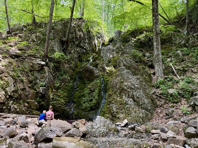
Located in Monroe, New York and nestled within the Hudson Valley sits the ~30-foot tall Fitzgerald Falls along the white blazed Appalachian Trail.

This easy, family-friendly 0.6-mile out-and-back hike leads visitors out to the scenic moss-covered bedrock and flow of the 30-foot tall Fitzgerald Falls.

Hiking to Fitzgerald Falls

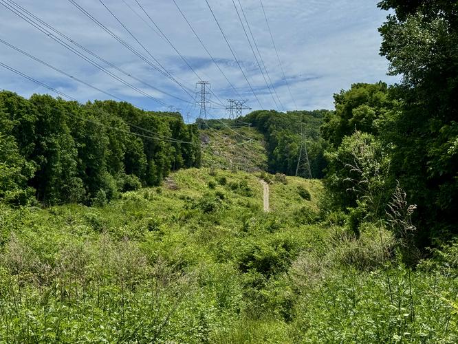
Starting along the south side of Dutch Hollow Road in Monroe, NY, hikers will find the white blazes of the Appalachian Trail leading down into the forest. The AT quickly exits the forest and passes through low-growing shrubs below powerlines before crossing a creek via a wooden footbridge.

On the far side of the footbridge, the Appalachian Trail runs back into the forest where you'll find a forest dominated by eastern hemlocks with a mostly-open floor. The AT undulates its way through the forest before spitting you out at the base of Fitzgerald Falls near mile 0.3.

From the base of Fitzgerald Falls, you'll find a mostly-seasonal (Spring) waterfall that spills down moss-covered bedrock at approximately 30-feet tall. On the south side of the waterfall, the Appalachian Trail ascends along rock steps that sit below a towering rock ledge. With the juxtaposition of Fitzgerald Falls alongside this short, but majestic section of the AT, it makes for a scenic family-friendly walk worth exploring.

To return to parking, simply follow the AT back out the same way you hiked in. Enjoy the trickle and clear water of the creek under the powerlines before reaching Dutch Hollow Road.

Parking

Hikers will find two small parking turnouts at the trailhead, located along Dutch Hollow Road at the parking coordinates: 41.273631, -74.2542. The parking turnouts are large enough to fit less than 5 vehicles each and are located on both sides of the road as of June 2026.

Pets

Dogs are allowed only if leashed and must be cleaned up after.

Warning

Poison ivy: This hike passes patches of poison ivy located just off-trail with some growing along the sides of the trail. Watch your step and be aware of what poison ivy looks like to avoid contact.
Explore 15 trails near Monroe, NY

Know Before You Go

  • This easy, 0.6-mile out-and-back trail along the iconic Appalachian Trail is perfect for families and leads directly to the scenic 30-foot waterfall.
  • Parking is highly limited to two small turnouts on Dutch Hollow Road that accommodate fewer than 5 vehicles each.
  • The waterfall is mostly seasonal, flowing best in the spring, and hikers should keep a sharp eye out for poison ivy patches growing just off-trail.
Interactive topographic map for Fitzgerald Falls via Appalachian Trail located in Monroe, NY. Click the "View Map" button to load GPS coordinates and trail markers.
Get directions
Distance
0.6 mi
Difficulty
Easy
Type
Out-and-Back
Est. Time
25 min
Elev. Gain
69'
Rating
0.0
Added
June 14, 2026
Updated
July 03, 2026

Weather Forecast

Don't let Google decide who you trust.

Loading...
Total Change
74 ft.
23 m
Ascent
69 ft.
21 m
Descent
84 ft.
26 m
Loading...

Download the GPX Data for Offline Use

Supporters get exclusive access to download trail routes to the MyHikes app for offline use. Stay prepared on your adventure, even without an internet connection! Become a Supporter today to unlock this feature and hike with confidence.

Download Fitzgerald Falls via Appalachian Trail GPX Data to the MyHikes Mobile App

Features

Dogs
Waterfalls
Water Source
Appalachian Trail logo Appalachian Trail hike

Points of interest

  1. Parking

    41.273631, -74.2542
  2. Main Trailhead

    41.273631, -74.2542
  3. Powerline viewpoint

    41.27335, -74.253761
    Powerline viewpoint
  4. Fitzgerald Falls, approx. 30-feet tall

    41.270931, -74.251189
    Fitzgerald Falls, approx. 30-feet tall

Safety information

For your own safety: plan ahead, let someone know where you'll be, and hike at your own risk.

Hazards

Poison Ivy or Poison Oak

Markers

Blaze Color

White

Availability

All seasons

Surface type

Dirt

Trip Reports (Reviews)

Your opinion matters! Be the first to rate this trail.

Ready to help fellow hikers? Add a trip report to share your experience!

No community routes found. To add your own hike as a Community Route for this Trail guide, leave a Trip Report with an attached GPX file.

You may also like

Colorado's Million Dollar Highway - Plan a day's drive adventure along the iconic Million Dollar Highway in Colorado. Explore the best short trails, roadside stops, waterfalls, vistas, ghost towns, and hot springs within a ~6 hour road trip.
Explore

Colorado's Million Dollar Highway

Plan a day's drive adventure along the iconic Million Dollar Highway in Colorado. Explore the best short trails, roadside stops, waterfalls, vistas, ghost towns, and hot springs within a ~6 hour road trip.

Read
Glacier's Going-to-the-Sun Road - Discover the breathtaking beauty of Glacier National Park along the iconic Going-to-the-Sun Road. From stunning roadside stops to picturesque waterfalls and vistas, this engineering marvel offers endless opportunities for exploration.
Explore

Glacier's Going-to-the-Sun Road

Discover the breathtaking beauty of Glacier National Park along the iconic Going-to-the-Sun Road. From stunning roadside stops to picturesque waterfalls and vistas, this engineering marvel offers endless opportunities for exploration.

Read
🍪 We use cookies to learn about site usage and to serve map tiles. You may block cookies manually in the browser. By continuing you agree. Learn more