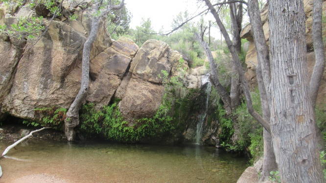
The First Creek Canyon Trail at Red Rock Canyon National Conservation Area in Las Vegas, Nevada is a moderate 3-mile out-and-back trail that features a waterfall along with stunning views of the neighboring mountains.
Trail Name: First Creek Canyon Trail.
Trailhead Location: Red Rock Canyon National Conservation Area, Las Vegas, NV.
Allowed activities: Hiking, biking, birding, geocaching, horseback riding.
Forbidden activities: No camping, no overnight parking, no target shooting.
Hours: There are no posted closing times at this trailhead.
Warning: Carry plenty of water when hiking in the desert. Temperatures change quickly, winds can be gusting. Thunderstorms with lightening and flash flooding are possible in summer. Wear a hat, dress in layers, wear sunscreen.
Parking: The parking is limited along the roadside.
Fees: There is no fee to park or to use the trail here. This area is not part of the Scenic drive loop and is directly off of Route 159.
Pets: Dogs on a leash are allowed on the trails. Please carry out animal waste with you.
Accessibility: For the most part the trail is free of any major foot hazards. There is some gravely areas with rocks peeking out along the substrate. To get to the hidden waterfall, a hiker will need to be able to walk on very uneven terrain and do some rock scrambling as well. Some of the sections steep.
Sanitation: There are no restrooms or trash bins at this trailhead.
Trail information: There is a kiosk with trail information at the Trailhead. A copy of the trails can be downloaded or printed by following the link below:
https://www.redrockcanyonlv.org/first-creek-canyon/
Length and features: This is an easy to moderate 3 mile trail done as an out and back hike. The trail substrate starts out as a gravely crushed stone. This part of the trail is wide and flat. There are several posts along part of the trail that look like telephone poles. There are no trail blaze markers along this trail but the poles and the foot traffic make the path easy to follow. The trail has quite a few small rocky outcroppings, so care needs to be taken with foot placement to avoid tripping or twisting an ankle. When descending the wash to see the waterfall, care should be taken when placing hands in rock holds. Desert dwellers may be sleeping in the crevices. At the end of the wash is a beautiful oasis and if a hiker is lucky, enough water to create a small waterfall and pool below.
There are no blaze trail markers and very few trail signs so the trail can be a bit confusing toward the end. This is a very popular trail, with many hikers and dog walkers using the trail. The views along the trail are incredible, and because of the abundant rain, the desert was ablaze in blooms all along the way. The sandstone rocks are interesting in shape, color and texture.