The Fire Tower Loop at Rothrock State Forest in Boalsburg, Pennsylvania is a moderate 4.1-mile loop hike that features a mountain climb and leads to an old fire tower called Little Flat Fire Tower.
Trails
This hike follows several named trails and roads including: the Galbraith Gap Trail, Lonberger Path, Spruce Gap Trail, Little Flat Tower Rd, Old Laurel Run Trail, and Laurel Run Rd.
Hike Description
This is a great loop from the Galbraith Gap parking area behind Tussey Mountain in Rothrock State Forest. The hike runs along Galbraith Gap Run before beginning the climb. Lonberger Path begins the climb, and then things really kick up a notch once you hit Spruce Gap Trail. Spruce Gap Trail climbs approx 800' over about a mile. The trail is rocky and gets very steep in places.
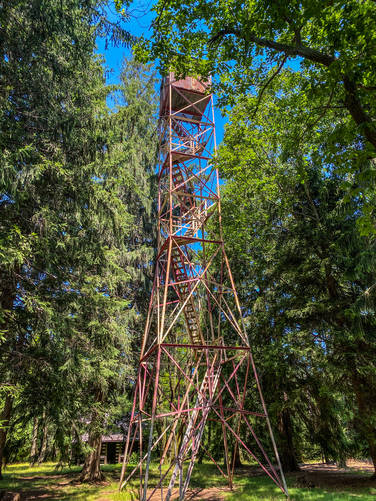
The fire tower at Little Flat is a very cool POI on this hike, located around mile 1.6. Unfortunately, the fire tower is no longer in use, so you can't climb to the top anymore.
On this hike we descended using Old Laurel Run Trail. This is a much easier way down than Spruce Gap. We used the gravel road (Laurel Run Rd) to link Old Laurel Run back to Galbraith Gap Trail back to the parking lot. Another option is to follow Three Bridges back to Lonberger and then follow that back the way you started.
Difficulty
I've kept the difficulty as 'moderate' simply because I did this hike with my 13 year-old and 7 year-old, and they didn't have any issues.
Pets
Dogs are allowed if leashed.
Trails
This hike follows several named trails and roads including: the Galbraith Gap Trail, Lonberger Path, Spruce Gap Trail, Little Flat Tower Rd, Old Laurel Run Trail, and Laurel Run Rd.
Hike Description
This is a great loop from the Galbraith Gap parking area behind Tussey Mountain in Rothrock State Forest. The hike runs along Galbraith Gap Run before beginning the climb. Lonberger Path begins the climb, and then things really kick up a notch once you hit Spruce Gap Trail. Spruce Gap Trail climbs approx 800' over about a mile. The trail is rocky and gets very steep in places.
The fire tower at Little Flat is a very cool POI on this hike, located around mile 1.6. Unfortunately, the fire tower is no longer in use, so you can't climb to the top anymore.
On this hike we descended using Old Laurel Run Trail. This is a much easier way down than Spruce Gap. We used the gravel road (Laurel Run Rd) to link Old Laurel Run back to Galbraith Gap Trail back to the parking lot. Another option is to follow Three Bridges back to Lonberger and then follow that back the way you started.
Difficulty
I've kept the difficulty as 'moderate' simply because I did this hike with my 13 year-old and 7 year-old, and they didn't have any issues.
Pets
Dogs are allowed if leashed.