Loading...

WINTER SALE! 50% OFF Supporter Accounts — now through January 31st. Learn More.

Ferry Way Trail

The Ferry Way Trail at the Great Bay National Wildlife Refuge in Newington, New Hampshire is an easy 2.1-mile loop and out-and-back hike. This is a solid hike close to Portsmouth, NH and is an easy walk - great for families.

The trail starts off at the refuge parking lot and follows an out-and-back section of the trail for just over a half-mile before you reach the loop portion. The loop itself is about 1.1-miles long before returning to the out-and-back section. Follow the loop to reach the edge of the Piscataqua River Bay / Great Bay and then follow the trail back to parking.

The trail was quite muddy in places, so I would suggest waterproof shoes if you want to do the whole thing during Spring or wetter months.

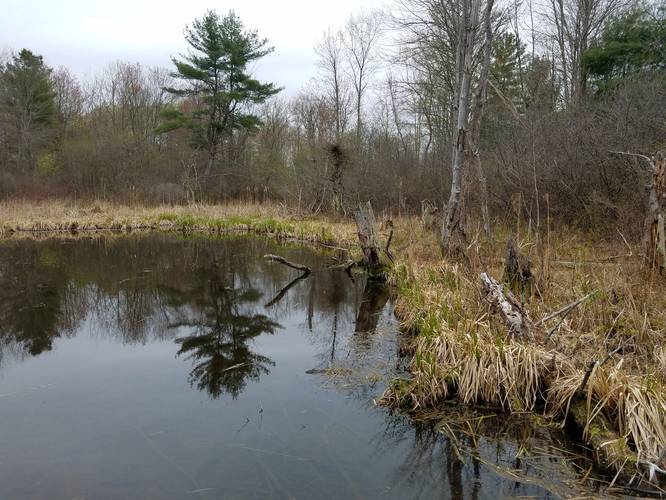
Wildlife Viewing: I saw turtles, beavers and birds off the side of the trail and picked some fiddleheads to cook later.

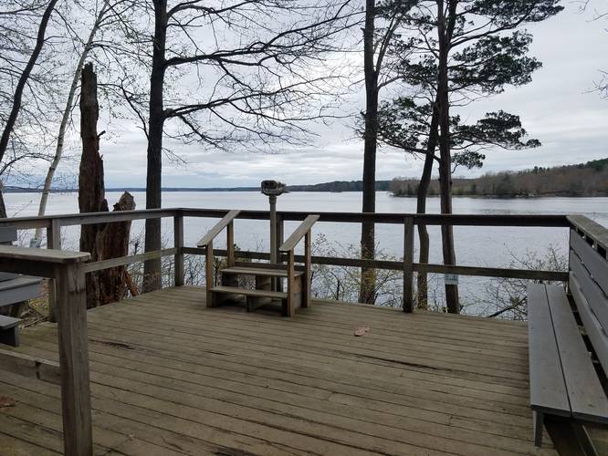
Lookout: At the far end of this loop you'll find scenic river views with some stationary binoculars to get a closer look at the river and the other side of the bank.

Parking: Parking can be found at the main lot for the Great Bay National Wildlife Refuge. The parking lot had plenty of space, and a nice building with bathrooms.
Explore 39 trails near Newington, NH

Know Before You Go

  • Ferry Way Trail is an easy, family-friendly 2.1-mile loop and out-and-back hike in Newington, NH, within the Great Bay National Wildlife Refuge.
  • The trail offers scenic river views with binoculars, opportunities for wildlife viewing (turtles, beavers, birds), and potential fiddlehead picking.
  • The trail can be muddy, especially in Spring or wetter months, so waterproof shoes are recommended, and there's ample parking with bathroom facilities at the refuge's main lot.
Interactive topographic map for Ferry Way Trail located in Newington, NH. Click the "View Map" button to load GPS coordinates and trail markers.
Get directions
Distance
2.1 mi
Difficulty
Easy
Type
Loop
Est. Time
1.1 hrs
Elev. Gain
318'
Rating
0.0
Added
May 05, 2019
Updated
May 05, 2019

Weather Forecast

Loading...
Total Change
135'
Ascent
318'
Descent
328'
Loading...

Download the GPX Data for Offline Use

Supporters get exclusive access to download trail routes to the MyHikes app for offline use. Stay prepared on your adventure, even without an internet connection! Become a Supporter today to unlock this feature and hike with confidence.

Download Ferry Way Trail GPX Data to the MyHikes Mobile App

Features

Vista / Lookout Point

Points of interest

  1. Parking

    43.089351, -70.843707
  2. Main Trailhead

    43.089082, -70.843318
  3. Vista point

    43.090565, -70.859876
    Vista point
  4. Pond

    43.089946, -70.850516
    Pond

Safety information

For your own safety: plan ahead, let someone know where you'll be, and hike at your own risk.

Availability

All seasons

Surface type

Dirt

Trip Reports (Reviews)

Your opinion matters! Be the first to rate this trail.

Ready to help fellow hikers? Add a trip report to share your experience and provide valuable insights for other hikers!

No community routes found. To add your own hike as a Community Route for this Trail guide, leave a Trip Report with an attached GPX file.

Popular categories

Scenic mountain view representing vista trails
Vista trails
Scenic gorge of cascades representing waterfall trails
Waterfall hikes
Rugged mountain terrain representing summit trails
Summit trails
Scenic mountain view representing dog-friendly trails
Dog-friendly
Scenic campsite with a view representing camping trails
Camping trails
Appalachian Trail logo representing A.T. hikes
A.T. hikes

You May Also Like

Colorado's Million Dollar Highway - Plan a day's drive adventure along the iconic Million Dollar Highway in Colorado. Explore the best short trails, roadside stops, waterfalls, vistas, ghost towns, and hot springs within a ~6 hour road trip.
Explore

Colorado's Million Dollar Highway

Plan a day's drive adventure along the iconic Million Dollar Highway in Colorado. Explore the best short trails, roadside stops, waterfalls, vistas, ghost towns, and hot springs within a ~6 hour road trip.

Read
Glacier's Going-to-the-Sun Road - Discover the breathtaking beauty of Glacier National Park along the iconic Going-to-the-Sun Road. From stunning roadside stops to picturesque waterfalls and vistas, this engineering marvel offers endless opportunities for exploration.
Explore

Glacier's Going-to-the-Sun Road

Discover the breathtaking beauty of Glacier National Park along the iconic Going-to-the-Sun Road. From stunning roadside stops to picturesque waterfalls and vistas, this engineering marvel offers endless opportunities for exploration.

Read
🍪 We use cookies to learn about site usage and to serve map tiles. You may block cookies manually in the browser. By continuing you agree. Learn more