Loading...

Distance:
7.3 Miles / 11.7 km
Type:
Loop
Difficulty:
Moderate
Time to Hike:
3 hours, ~39 minutes
Features:
Surface Type:
Dirt
Park:
Plumas National Forest
Town:
Oroville, California
Directions:
39.614214, -121.266489
Added:
February 17, 2017
Updated:
February 11, 2020
Loading...
Loading...
1,048 '

Total Change
1,425 '

Ascent
1,420 '

Descent

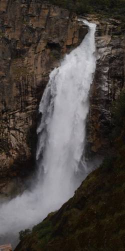
The Feather Falls Trail in Plumas National Forest near Oroville, California is a moderate 7.3-mile loop trail that features beautiful views of Feather Falls - a 400+ foot waterfall.

Feather Falls is one of California's best waterfalls, outside of Yosemite. In the Spring, the waterfall roars approximately 410-feet downstream toward Lake Oroville. The waterfall can be visited year-round, but the hike to reach the waterfall is not short. The hike is just over 7-miles if you complete the loop. If you hike this out-and-back, you can make a similar distance without having to hike the entire loop as well.

Views
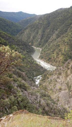
The trail also includes beautiful vistas from the mountainside looking down stream.

For more details check out the Feather Falls Norcalhiker blog post.

  1. Parking

    39.614214, -121.266489
  2. Main Trailhead

    39.614383, -121.266639
  3. Feather Falls

    39.641776, -121.275146
    Feather Falls
  4. Vista

    39.64174, -121.27495
    Vista
No community routes found. To add your own hike as a Community Route for this Trail guide, leave a Trip Report with an attached GPX file.

Hazards

Ticks - Lyme Disease More Info (CDC)

Seasons

All

Photo Albums

1 Trip Report

No Star-Ratings
Trail Guide By:
Norcalhiker user profile picture
7.3 miles / 11.7 km
Trail added
February 17, 2017
Hiked on
February 17, 2017
Updated on
February 11, 2020

Weather Forecast

In Oroville, CA

Explore Hiking Trails

New Hikes

State Camp CCC Trail
0.7 Miles
1.1 km
Easy
Loop
Gorge Trail (Stony Brook)
0.8 Miles
1.3 km
Moderate
One-Way
Lake Estes Trail
0.9 Miles
1.4 km
Easy
Out-and-Back
Mary's Lake Trail
0.6 Miles
1 km
Easy
Out-and-Back

Before you boogie...

Find our trail guides useful? Consider becoming a Supporter to unlock perks!

MyHikes is an indie platform that makes exploring public trails easier for everyone. The platform has no investors, runs no ads, and is owned and operated by one person, Dave Miller. Dave has personally mapped and written over 1,600 trail guides on MyHikes for the public to explore. As of 2024, MyHikes has helped over 1,300,000 outdoor enthusiasts plan their next adventure.

But it takes a lot of time 🕦, money 💰, and work, and espresso shots ☕ to run MyHikes, including hiking , mapping , writing , and publishing new trails with high-quality (accurate) information... along with software engineering (coding) the platform like building new features, site and mobile app development for iOS and Android, site maintainance . and much much more.

Supporters unlock website and mobile app perks with an annual one-time payment of $25 (you renew) 😎👍. Or you can simply make a Donation of your choice. Otherwise, you can support us by telling your friends about MyHikes - both quick and free 🎉

Admin user profile picture

Dave Miller
MyHikes Founder