The Fay Canyon Trail at Coconino National Forest in Sedona, Arizona is a moderate 2.7-mile out-and-back hike that leads to the Fay Canyon Arch and features spectacular views of the Fay Canyon.
Trail names: Fay Canyon Trail, Fay Canyon Arch Trail
Location: Boynton Pass Road, Red Rock Secret Mountain Wilderness, Coconino National Forest, Sedona Arizona
Permitted uses: Hiking, Running, Walking, Nature Study, Horseback riding, Birding.
Prohibited uses: Closed to motor vehicles and motorized equipment. No hang gliders or bicycles allowed. Do not disturb ruins or remove artifacts. No marking or defacing rocks. No Camping. No Drone usage.
Fees and Parking: There is conflicting information online about paying a fee to hike here. Some sites report that a $5.00 Red Rock pass is needed, and others say there is No fee. When we visited there was no fee to park or use the trails. There is ample parking at the trailhead.
Pets: Dogs MUST be on a leash and owners must remove dog waste.
Accessibility: The trail is not wheelchair accessible.
Sanitation: There is a gender-neutral vault restroom with a trash receptacle available at trailhead parking area.
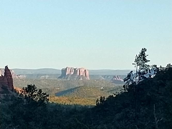
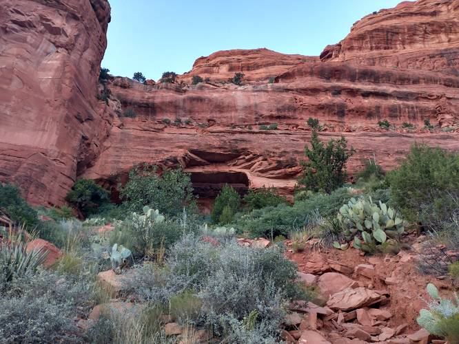
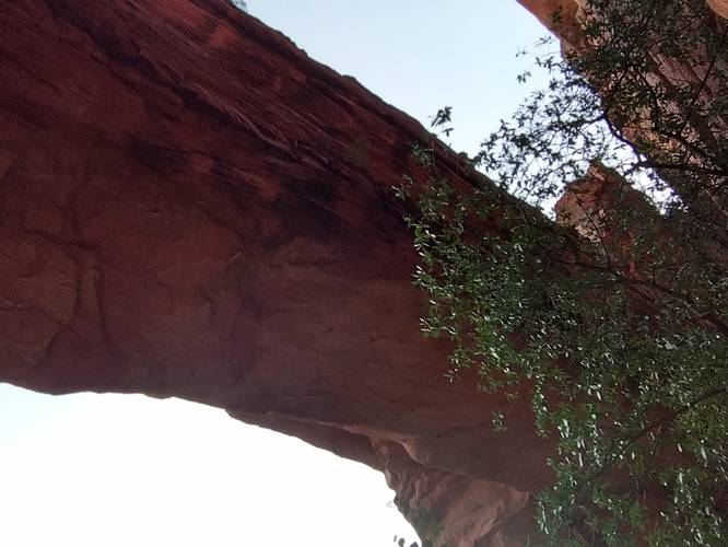
Length and Trail information: This is a 2.7-mile trail done as an out and back hike, considered to be an easy hike for all skill levels. The Trailhead parking area has an information Kiosk with an excellent map and also a bike repair station. The trail starts across the street from the parking area. The trail substrate is wide and flat in many sections. On our visit, during September 2023, the trail was surrounded by so many blooming wildflowers that we felt as if we were walking through a botanical garden. We chose to hike in late afternoon to escape the dangerously high temperatures and by doing so, we were able to hike in complete shade. There is a lot of tree canopy, so even if a hiker chooses to go during the day, there most likely will be some shade while hiking. By hiking later in the day, we also avoided the crowds. This lovely hike tends to attract a lot of visitors, but during our hike we only saw 4 other hikers. There are no trail blazes to mark either of the trails, but the Fay Canyon trail is fairly obvious. Most of the substrate on Fay Canyon Trail was without major trip hazards with only an occasional rock section or wash to cross. There is some rock scramble at the end of the trail if you choose to do so. A short climb up the rocks past the end of the trail, affords lovely views of the valley. If you want to include hiking to see the Fay Canyon Arch trail, make sure you know where that trail begins before you head out. The trail to the Arch begins roughly 0.6 miles from the trails start. There is no signage to alert hikers that the trail is there. On our hike out, we missed the trail. However, we were able to find it on the way back. The Fay Canyon Arch trail is very different from the Canyon trail. The Arch trail is steep, rocky and easy to get sidetracked if you are not paying attention. The arch is roughly 200 feet up the north side of the Canyon and offers hikers a spectacular view of the Sandstone Arch and the Canyon below.
Trail names: Fay Canyon Trail, Fay Canyon Arch Trail
Location: Boynton Pass Road, Red Rock Secret Mountain Wilderness, Coconino National Forest, Sedona Arizona
Permitted uses: Hiking, Running, Walking, Nature Study, Horseback riding, Birding.
Prohibited uses: Closed to motor vehicles and motorized equipment. No hang gliders or bicycles allowed. Do not disturb ruins or remove artifacts. No marking or defacing rocks. No Camping. No Drone usage.
Fees and Parking: There is conflicting information online about paying a fee to hike here. Some sites report that a $5.00 Red Rock pass is needed, and others say there is No fee. When we visited there was no fee to park or use the trails. There is ample parking at the trailhead.
Pets: Dogs MUST be on a leash and owners must remove dog waste.
Accessibility: The trail is not wheelchair accessible.
Sanitation: There is a gender-neutral vault restroom with a trash receptacle available at trailhead parking area.
Length and Trail information: This is a 2.7-mile trail done as an out and back hike, considered to be an easy hike for all skill levels. The Trailhead parking area has an information Kiosk with an excellent map and also a bike repair station. The trail starts across the street from the parking area. The trail substrate is wide and flat in many sections. On our visit, during September 2023, the trail was surrounded by so many blooming wildflowers that we felt as if we were walking through a botanical garden. We chose to hike in late afternoon to escape the dangerously high temperatures and by doing so, we were able to hike in complete shade. There is a lot of tree canopy, so even if a hiker chooses to go during the day, there most likely will be some shade while hiking. By hiking later in the day, we also avoided the crowds. This lovely hike tends to attract a lot of visitors, but during our hike we only saw 4 other hikers. There are no trail blazes to mark either of the trails, but the Fay Canyon trail is fairly obvious. Most of the substrate on Fay Canyon Trail was without major trip hazards with only an occasional rock section or wash to cross. There is some rock scramble at the end of the trail if you choose to do so. A short climb up the rocks past the end of the trail, affords lovely views of the valley. If you want to include hiking to see the Fay Canyon Arch trail, make sure you know where that trail begins before you head out. The trail to the Arch begins roughly 0.6 miles from the trails start. There is no signage to alert hikers that the trail is there. On our hike out, we missed the trail. However, we were able to find it on the way back. The Fay Canyon Arch trail is very different from the Canyon trail. The Arch trail is steep, rocky and easy to get sidetracked if you are not paying attention. The arch is roughly 200 feet up the north side of the Canyon and offers hikers a spectacular view of the Sandstone Arch and the Canyon below.