Located in north Connecticut sits Tunxis State Forest near Hartland, CT where the forest holds a secret series of waterfalls that tumble down Falls Brook.
This moderate 1.3-mile out-and-back hike leads visitors to two large waterfalls and leads directly to the base of Falls Brook Falls. Both large waterfalls along the hike are approximately 20 to 30-feet tall and can be appreciated from just off-trail.
Ledges: The trail that leads to the top of Upper Falls Brook Falls leads out to a series of ledges that sit alongside the waterfall. Be careful and watch your step near the edge. Only scramble down if you have experience.
This moderate 1.3-mile out-and-back hike leads visitors to two large waterfalls and leads directly to the base of Falls Brook Falls. Both large waterfalls along the hike are approximately 20 to 30-feet tall and can be appreciated from just off-trail.
Hiking to Falls Brook Falls
This hike begins on the southwest side of Morrison Hill Road (CT-20) at a discrete trailhead. The trail leads into the forest and quickly descends toward Falls Brook. The hike through the forest is fairly uneventful, but be on the lookout for plenty of roots and rocks that fill the trail to watch your step. Keep left at any trail junction that presents itself, following signs for Falls Brook Falls.Small Waterfall - Mile 0.5
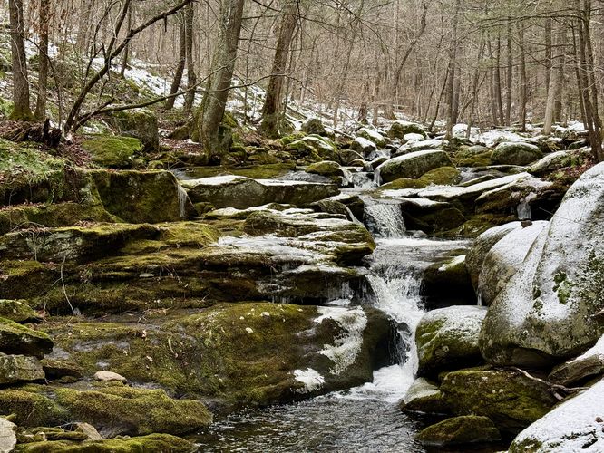
Located just upstream from the two large waterfalls in Falls Brook is a short, ~5-foot tall tumbling cascade that swoops down the brook. This short waterfall is a great spot to take a little break and to prepare for some fun off-trail exploration to reach the larger Falls Brook waterfalls!Upper Falls Brook Falls - Mile 0.6
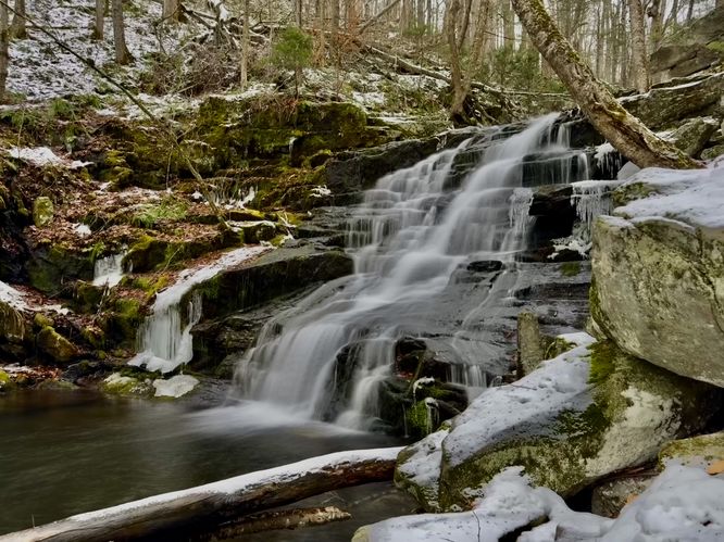
Just a few-hundred feet south of the 5-foot cascade sits Upper Falls Brook Falls, a ~20-foot tall waterfall that spills down the exposed bedrock in Falls Brook. This waterfall can be viewed by following a short trail that skirts away from the main path and out to the top of the cascade. If you're experienced with rock scrambles, you can scramble your way down the large boulders and exposed rock to reach the base of Upper Falls Brook Falls to appreciate its beauty from the bottom of the plummeting waterfall.Falls Brook Falls - Mile 0.7
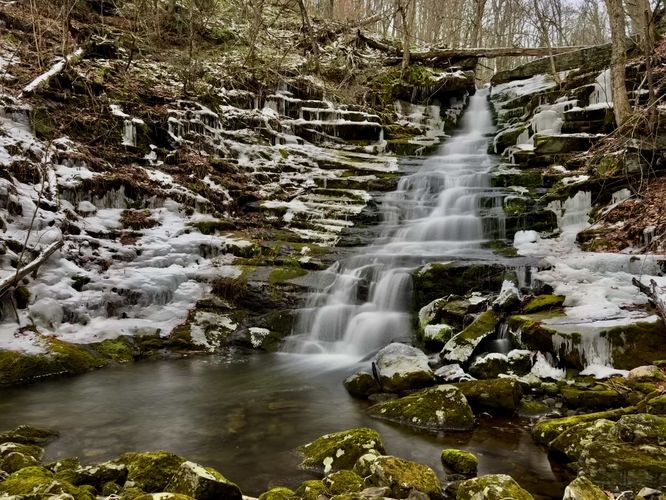
One last waterfall to explore is the true and proper Falls Brook Falls, located downstream from Upper Falls Brook Falls. This route leads hikers back to the main path before it follows an unmaintained trail that leads further down the creek. Once you get far enough, you'll notice Falls Brook Falls plummeting down the creek. To reach the base of Falls Brook Falls, you'll have to commit to a very-steep loose soil scramble that leads down to the creek. Be careful, if you plan to reach the base of Falls Brook Falls as the loose soil can be dangerous. From the base of the ~30-foot tall Falls Brook Falls, hikers can appreciate the tranquil, quiet forest setting while watching the waterfall cascade down the hillside. Remember, the hike back up to the trail is a heart pumper, so be prepared for a bit more effort to get back.Hiking Out - Mile 0.7 to 1.3
The last leg of this hike is the walk back to parking. The hike back is straight forward - simply head back up the trail and keep right at each trail junction. Reach the parking area at mile 1.3 to wrap up the hike.Parking
Hikers will find a small parking turnout with roadside parking at the coordinates provided: . The turnout is large enough to fit just a few vehicles as of December 2025.Pets
Dogs are allowed only if leashed and must be cleaned up after.Warning
Off-trail scramble: This hike leads down an off-trail loose soil scramble that leads to the base of Falls Brook Falls. If you wish to visit a waterfall without this annoying, somewhat dangerous scramble, you can do so at Upper Falls Brook Falls, simply skipping the lower-most waterfall.Ledges: The trail that leads to the top of Upper Falls Brook Falls leads out to a series of ledges that sit alongside the waterfall. Be careful and watch your step near the edge. Only scramble down if you have experience.